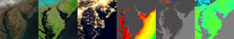
The Global Imagery Browse Services (GIBS) vision is to provide visual access to NASA’s Earth observations through standardized web services. These services are designed to facilitate visual discovery of scientific phenomena, support timely decision making for natural hazards, educate the next generation of scientists, and make imagery of the planet more accessible to the media and public. Browse all of this imagery through our Worldview interface.
Access Imagery
- GIBS Visualization Product Catalog
- GIBS API for Developers to connect to imagery
- Accessing via Map Libraries and Scripts
- Accessing via GIS Applications
- Accessing via Python
- View and interact with the imagery in Worldview and Worldview Snapshots
Stay Informed
- Overview of GIBS
- GIBS Blog: Stay up-to-date with GIBS developments
- GIBS Mailing List: Get occasional emails about the newest capabilities and imagery; send an email to eosdis-gibs-announce-join@lists.nasa.gov to join (no subject or text in the body is needed)
- Send us feedback or ask for help!
Open Source Code: GIBS on GitHub
- OnEarth: High-performance web services for tiled raster imagery and vector tiles
- MRF Tiled Imagery Storage Format: GDAL-compatible file format driver designed for fast access to imagery
- Mapping Examples: Examples of using GIBS with various web mapping libraries
- Worldview: Interactive interface for browsing daily, global, full-resolution satellite imagery
Blog Posts
-
Worldview's "Embed Mode" is BACK! ...with a caveat
created by
Sep 13, 2023
-
Reveal previously hidden classifications to get more out of visualizations in Worldview
created by
Sep 12, 2023
-
Use Python to access the GIBS API (and we've updated our web examples)
created by
Apr 25, 2023
-
Tips for Using Worldview on Mobile Devices
created by
Jan 17, 2023
-
Viewing Multiple Natural Event Tracks Now Available!
created by
Nov 07, 2022
Information about working with this wiki
Overview
Content Tools