Worldview is now providing users with the ability to toggle on/off classifications that were previously hidden to the user as transparent pixel values.
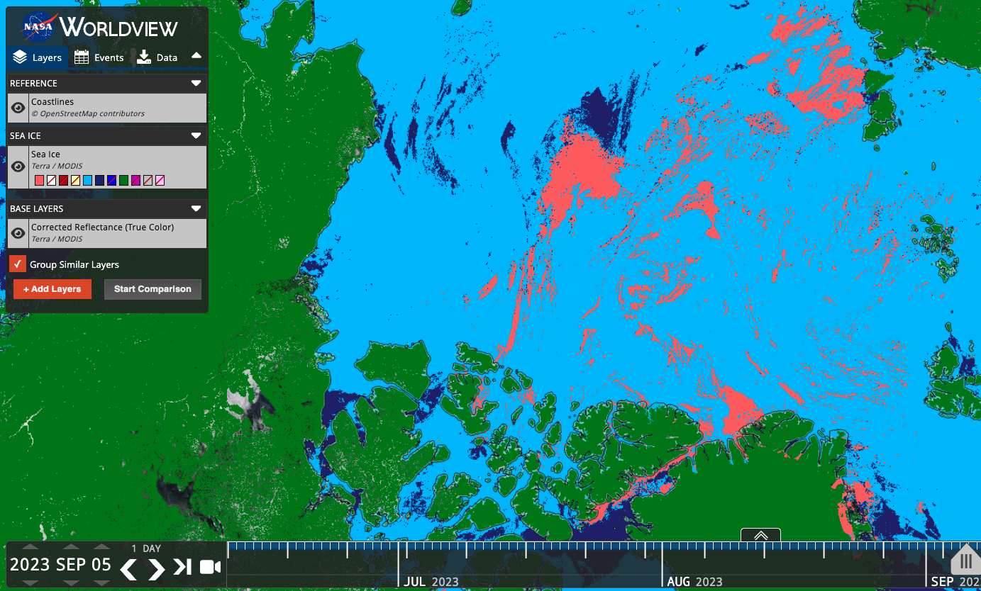
In the example below, the Sea Ice Extent layer previously showed only the sea ice values (Figure 1), but the colormap included other potentially interesting and useful classifications, such as Cloud, Land, Missing Data, etc. Users can now toggle on/off these other classifications (Figure 2) to show relevant information like the location of clouds that may obscure sea ice. Now users have more contextual information to assess these visualizations.
Below is a list of the layers that now show previously hidden pixel classifications.
Figure 1: Sea Ice classification layer from the MODIS instrument aboard the Terra satellite. Sea ice is shown in dark pink, overlaid on a corrected reflectance image from the same satellite and sensor.

Figure 2. Sea Ice classification layer from the MODIS instrument aboard the Terra satellite. Sea ice is shown in dark pink, cloud in light blue, ocean in dark blue, and land in green. With these other classifications displayed, we now have a better idea of what areas that may have had sea ice were actually obscured by cloud, and the areas that are land masses.
Layers that now show previously hidden pixel classifications
| Satellite/Sensor | Layer Name and link to Worldview | Layer ID |
|---|---|---|
| Terra/MODIS | Cloud Phase Infrared (Day) | MODIS_Terra_Cloud_Phase_Infrared_Day |
| Terra/MODIS | Cloud Phase Infrared (Night) | MODIS_Terra_Cloud_Phase_Infrared_Night |
| Aqua/MODIS | Cloud Phase Infrared (Day) | MODIS_Aqua_Cloud_Phase_Infrared_Day |
| Aqua/MODIS | Cloud Phase Infrared (Night) | MODIS_Aqua_Cloud_Phase_Infrared_Night |
| Terra/MODIS | Cloud Phase Optical Properties | MODIS_Terra_Cloud_Phase_Optical_Properties |
| Aqua/MODIS | Cloud Phase Optical Properties | MODIS_Aqua_Cloud_Phase_Optical_Properties |
| Terra/MODIS | Cloud Multi Layer Flag | MODIS_Terra_Cloud_Multi_Layer_Flag |
| Aqua/MODIS | Cloud Multi Layer Flag | MODIS_Aqua_Cloud_Multi_Layer_Flag |
| Terra/MODIS | Areas of No Data (mask) | MODIS_Terra_Data_No_Data |
| Aqua/MODIS | Areas of No Data (mask) | MODIS_Aqua_Data_No_Data |
| Terra and Aqua/MODIS | Flood (2-Day Window) | MODIS_Combined_Flood_2-Day |
| Terra and Aqua/MODIS | Flood (3-Day Window) | MODIS_Combined_Flood_3-Day |
| Terra/MODIS | Sea Ice | MODIS_Terra_Sea_Ice |
| Aqua/MODIS | Sea Ice | MODIS_Aqua_Sea_Ice |
| Terra/MODIS | Sea Ice Extent (L3, Daily) | MODIS_Terra_L3_Sea_Ice_Daily |
| Aqua/MODIS | Sea Ice Extent (L3, Daily) | MODIS_Aqua_L3_Sea_Ice_Daily |
| Terra/MODIS | Land/Water Mask (L3, Annual) | MODIS_Terra_L3_Land_Water_Mask |
| DSWx-HLS | OPERA Dynamic Surface Water Extent Provisional | OPERA_Dynamic_Surface_Water_Extent |
| SMAP/Radiometer | Freeze/Thaw 9 km (L3, Passive, Day) | SMAP_L3_Passive_Enhanced_Day_Freeze_Thaw |
| SMAP/Radiometer | Freeze/Thaw 9 km (L3, Passive, Night) | SMAP_L3_Passive_Enhanced_Night_Freeze_Thaw |
| SMAP/Radiometer | Freeze/Thaw 36 km (L3, Passive, Day) | SMAP_L3_Passive_Day_Freeze_Thaw |
| SMAP/Radiometer | Freeze/Thaw 36 km (L3, Passive, Night) | SMAP_L3_Passive_Night_Freeze_Thaw |
| Aqua/AMSR-E | Freeze/Thaw (Daily Landscape) | MEaSUREs_Daily_Landscape_Freeze_Thaw_AMSRE |
| DMSP/SSMI | Freeze/Thaw (Daily Landscape) | MEaSUREs_Daily_Landscape_Freeze_Thaw_SSMI |
Overview
Content Tools