Earlier this year, we highlighted the availability of Landsat 8 and Landsat 9 Operational Land Imager (OLI) imagery in the FIRMS map viewers. This imagery, provided by NASA's IMPACT project, enables a relatively high spatial resolution perspective of fire activity and post-fire effects. Similar to MODIS and VIIRS, we are now providing active fire data in FIRMS, generated from Landsat observations.
This new near real-time (NRT) Landsat operational active fire product is the result of an ongoing collaboration by NASA LANCE/FIRMS, University of Maryland, USDA Forest Service and USGS EROS Data Center. Daily Landsat 8 and Landsat 9 OLI imagery for CONUS and most of Canada and Mexico are collected via direct readout by USGS EROS Data Center in Sioux Falls, South Dakota. At the request of NASA and the USDA Forest Service, USGS developed a near real-time data processing framework that provides Level 1 terrain corrected Landsat OLI imagery. This imagery is subsequently processed using NASA science data processing algorithms to generate Level 2 30 meter resolution active fire data. The total elapsed time from satellite overpass to the availability of Landsat active fire detection data in FIRMS is 30 minutes or less. Users should note that these Landsat active fire detection data are provided much sooner than the Harmonized Landsat-Sentinel (HLS) imagery products, that are dynamically generated, and currently available in FIRMS approximately 2 days after acquisition.
How does Landsat active fire data compare with MODIS and VIIRS active fire data?
Landsat active fire data is more than 1,000 times more resolute than MODIS and more than 150 times more resolute than MODIS and VIIRS, respectively. The algorithm routinely detects fires as small as a few square meters, or smaller, providing spatially explicit detail of location and extent of fire activity at the time of satellite overpass. Active fire fronts, as well as scattered smaller fires within the fire perimeter are routinely detected. However, these relatively high spatial resolution data have a lower temporal resolution compared to the daily observation frequency afforded by MODIS and VIIRS. Between both Landsat OLI instruments, areas in the lower to mid latitudes are imaged every 8 days (please see the related NASA FIRMS blog entry that describes the characteristics of different satellite sensors and their effects on the spatial extent of daily active fire data). The temporal resolution of Landsat data can be increased though collection of nighttime Landsat 8 and Landsat 9 imagery for targeted areas.
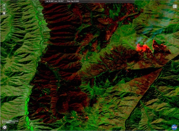
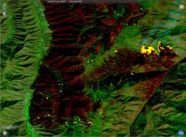
A September 10, 2022 HLS Landsat 9 OLI false color composite image for the southern portion of the Double Creek Fire in northeast Oregon. In the top image, burned areas appear in dark red hues while both isolated and broadly burning areas appear bright orange-red. The bottom image highlights the 30-meter active fire detections (yellow) that correspond to actively burning areas. Users should note that Landsat active fire detection data is available in FIRMS in near real-time approximately 30 minutes after acquisition while corresponding Landsat imagery is generated dynamically and available in FIRMS 2-3 days after acquisition.
Overview
Content Tools