Earlier this year, FIRMS integrated the Harmonized Landsat/Sentinel-2 (HLS) Imagery product. This data stream has recently been enhanced with the integration of Landsat 9 data. Users can now integrate HLS True Color and False Color Composite Imagery from Landsat 9 in addition to Landsat 8. Both Landsat instruments image every location on the Earth's surface at least every 16 days and their respective orbits are 8 days out of phase. As a result, they provide 8 day repeat coverage of any area on the globe. With the two Landsat instruments and two Sentinel-2 instruments, the HLS data stream allows for 30 meter land surface observations every 2-3 days.
HLS data services are made available by the NASA Interagency Implementation and Advanced Concepts Team (IMPACT) and can be visualized in FIRMS map viewers approximately 2-4 days after acquisition. Please see the April 2022 FIRMS blog post for additional information on the HLS data product and how to access it in FIRMS.
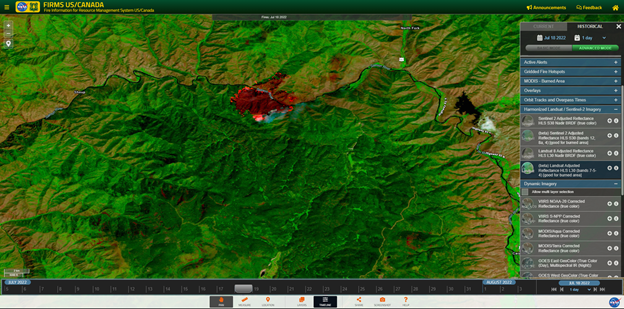
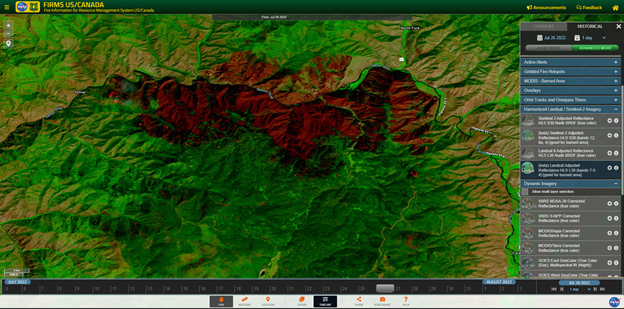
HLS false color composite image for the Moose Fire in northeast Idaho acquired by Landsat 8 on July 18, 2022 (top). The HLS false color image acquired on July 26, 2022 by Landsat 9 (bottom) illustrates the growth of the fire over that 8 day period. Note active fire areas in these images appear as glowing orange.
Overview
Content Tools