Page History
FIRMS delivers global MODIS hotspots / fire locations in easy to use formats
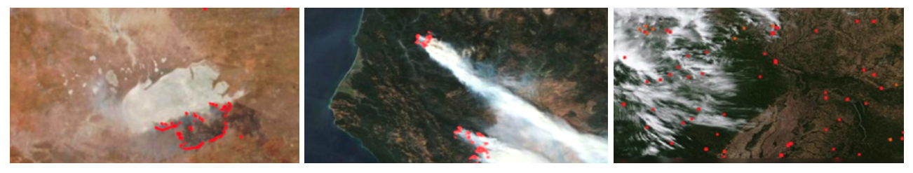
The near real-time (NRT) active fire locations are processed by LANCE using the standard MODIS MOD14/MYD14 and VIIRS 375m Fire and Thermal Anomalies algorithms. For more information and active fire data go to: http://earthdata.nasa.gov/firms
New: FIRMS US/Canada - a joint effort by NASA and the USDA Forest Service
FIRMS Blog: Stay up to date with FIRMS developments
Background
FIRMS was developed by the University of Maryland, with funds from NASA’s Applied Sciences Program and the UN Food and Agriculture Organization, to provide near real-time active fire locations to natural resource managers that faced challenges obtaining timely satellite-derived fire information.
An operational version of FIRMS, known as the Global Fire Information Management System (GFIMS) was running at the United Nations Food and Agriculture Organization (UN FAO) where it complemented the FAO’s existing suite of projects that deliver near-real time information to ongoing monitoring and emergency projects, to other UN organizations as well as providing information to the general public. This is no longer supported.
For more information on the MODIS fire products, visit the UMD MODIS Active Fire and Burned Area products website.
Product User Manual
Fire Radiative Power Products: GOES-R and Himawari Satellites - Provided by Martin Wooster Feb 2002
FIRMS Blog Posts
- New Near Real-Time Product in FIRMS – Landsat Active Fire Data – October 2022
- Characteristics of VIIRS, MODIS and OLI Sensors and Their Effects on the Spatial Extent of Daily Active Fire Data – September 2022
- New Enhancements Make Generating Imagery Subsets in Worldview Snapshots Even Easier – October 2022
- Landsat 9 Now Included in Harmonized Landsat/Sentinel-2 Imagery – August 2023
- How to customize the fires displayed in FIRMS – July 2022
- Wildfire detection in the US and Canada within a minute of satellite observation – July 2022
- New - GeoTIFF from FIRMS Screenshot – July 2022
- New - Harmonized Landsat/Sentinel-2 Imagery (beta version) – April 2022
- New FIRMS Feature / Location Tool – January 2022
- Basic and Advanced Modes for FIRMS Users – August 2021
- Where’s the smoke coming from? – July 2021
- Additional information about wildland fires in US and Canada – July 2021
- New FIRMS Feature/Capability Highlight – June 2021
- New Web Services added to FIRMS US/Canada and FIRMS Global – June 2021
- FIRMS US/Canada Prototype Released – January 2021
Communication Material
FIRMS Flyers (Nov 2022):
FIRMS Postcard (March 2023):
Presentations and Posters
- FIRMS Poster for IWFC, Porto
- LANCE FIRMS for NOAA VIIRS User meeting
- LANCE FIRMS AMS Annual Conference, Jan 2023
- LANCE FIRMS AGU Annual Meeting, Dec 2022
- LANCE FIRMS 610 Directors Seminar Oct 2022
- FIRMS GOFC-Fire June 2022
- LANCE FIRMS - USFS_final.pptx
- FIRMS EARSel 2019
| Hide comments |
|---|
| Hide child pages |
|---|
Overview
Content Tools