Blog from September, 2023
search
attachments
weblink
advanced
Overview
Content Tools
Back in July 2021, we released the capability for others to embed Worldview into their own sites in response to a desire by science and news organizations to provide a mechanism for their readers to interactively explore NASA data as part of their storytelling process. This "embed mode" provided a streamlined interface to focus on specific interactions such as comparing how a forest looks before and after a wildfire.
We unfortunately needed to take this mode offline in December 2022, but we've been working hard with multiple teams to bring it back online since then. The good news: it's back! The caveat is that Worldview embedding on non-NASA sites is disabled by default; you'll need to contact us to enable embedding Worldview on your site by writing to us at support@earthdata.nasa.gov or clicking on the "i" icon in Worldview's upper right corner and selecting "Send Feedback".
We're excited to have this capability again - please get in touch whenever you're ready to use it!
Background information on Embed mode:
- Worldview’s New Embed Feature Makes Telling Data-Driven Stories Easier than Ever
- Examples of Embedded Worldview
- Technical documentation on embedding Worldview
Sample of an embedded Worldview instance from the Worldview Image of the Week: High Aerosol Index from Smoky Canadian Fires. Click the Play button in the lower left corner (or the bottom center of the page depending on the width of your browser window) to view an animation spanning August 1 to September 6, 2023, showing high Aerosol Index values due to continued wildfires in Canada.
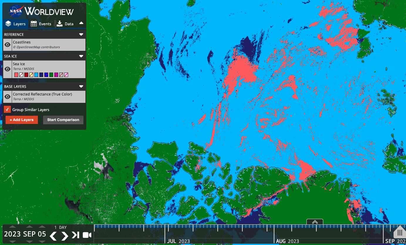
Worldview is now providing users with the ability to toggle on/off classifications that were previously hidden to the user as transparent pixel values.
In the example below, the Sea Ice Extent layer previously showed only the sea ice values (Figure 1), but the colormap included other potentially interesting and useful classifications, such as Cloud, Land, Missing Data, etc. Users can now toggle on/off these other classifications (Figure 2) to show relevant information like the location of clouds that may obscure sea ice. Now users have more contextual information to assess these visualizations.
Below is a list of the layers that now show previously hidden pixel classifications.
Figure 1: Sea Ice classification layer from the MODIS instrument aboard the Terra satellite. Sea ice is shown in dark pink, overlaid on a corrected reflectance image from the same satellite and sensor.

Figure 2. Sea Ice classification layer from the MODIS instrument aboard the Terra satellite. Sea ice is shown in dark pink, cloud in light blue, ocean in dark blue, and land in green. With these other classifications displayed, we now have a better idea of what areas that may have had sea ice were actually obscured by cloud, and the areas that are land masses.
Layers that now show previously hidden pixel classifications
| Satellite/Sensor | Layer Name and link to Worldview | Layer ID |
|---|---|---|
| Terra/MODIS | Cloud Phase Infrared (Day) | MODIS_Terra_Cloud_Phase_Infrared_Day |
| Terra/MODIS | Cloud Phase Infrared (Night) | MODIS_Terra_Cloud_Phase_Infrared_Night |
| Aqua/MODIS | Cloud Phase Infrared (Day) | MODIS_Aqua_Cloud_Phase_Infrared_Day |
| Aqua/MODIS | Cloud Phase Infrared (Night) | MODIS_Aqua_Cloud_Phase_Infrared_Night |
| Terra/MODIS | Cloud Phase Optical Properties | MODIS_Terra_Cloud_Phase_Optical_Properties |
| Aqua/MODIS | Cloud Phase Optical Properties | MODIS_Aqua_Cloud_Phase_Optical_Properties |
| Terra/MODIS | Cloud Multi Layer Flag | MODIS_Terra_Cloud_Multi_Layer_Flag |
| Aqua/MODIS | Cloud Multi Layer Flag | MODIS_Aqua_Cloud_Multi_Layer_Flag |
| Terra/MODIS | Areas of No Data (mask) | MODIS_Terra_Data_No_Data |
| Aqua/MODIS | Areas of No Data (mask) | MODIS_Aqua_Data_No_Data |
| Terra and Aqua/MODIS | Flood (2-Day Window) | MODIS_Combined_Flood_2-Day |
| Terra and Aqua/MODIS | Flood (3-Day Window) | MODIS_Combined_Flood_3-Day |
| Terra/MODIS | Sea Ice | MODIS_Terra_Sea_Ice |
| Aqua/MODIS | Sea Ice | MODIS_Aqua_Sea_Ice |
| Terra/MODIS | Sea Ice Extent (L3, Daily) | MODIS_Terra_L3_Sea_Ice_Daily |
| Aqua/MODIS | Sea Ice Extent (L3, Daily) | MODIS_Aqua_L3_Sea_Ice_Daily |
| Terra/MODIS | Land/Water Mask (L3, Annual) | MODIS_Terra_L3_Land_Water_Mask |
| DSWx-HLS | OPERA Dynamic Surface Water Extent Provisional | OPERA_Dynamic_Surface_Water_Extent |
| SMAP/Radiometer | Freeze/Thaw 9 km (L3, Passive, Day) | SMAP_L3_Passive_Enhanced_Day_Freeze_Thaw |
| SMAP/Radiometer | Freeze/Thaw 9 km (L3, Passive, Night) | SMAP_L3_Passive_Enhanced_Night_Freeze_Thaw |
| SMAP/Radiometer | Freeze/Thaw 36 km (L3, Passive, Day) | SMAP_L3_Passive_Day_Freeze_Thaw |
| SMAP/Radiometer | Freeze/Thaw 36 km (L3, Passive, Night) | SMAP_L3_Passive_Night_Freeze_Thaw |
| Aqua/AMSR-E | Freeze/Thaw (Daily Landscape) | MEaSUREs_Daily_Landscape_Freeze_Thaw_AMSRE |
| DMSP/SSMI | Freeze/Thaw (Daily Landscape) | MEaSUREs_Daily_Landscape_Freeze_Thaw_SSMI |