We are pleased to announce that two new sets of imagery products are now available in GIBS:
- Aqua / AMSR-E (Advanced Microwave Scanning Radiometer-EOS) Brightness Temperature consisting of
- MEaSUREs (Making Earth System Data Records for Use in Research Environments) Global Record of Daily Landscape Freeze/Thaw consisting of
These products mark two milestones for the GIBS project:
- Imagery has been visualized and is available for every day throughout the entire MEaSUREs Freeze/Thaw and AMSR-E Brightness Temperature mission. Most of the other products in GIBS do not yet contain imagery from the entire mission duration.
- The Freeze/Thaw product is the first of many MEaSUREs datasets to be visualized and made available through GIBS.
More details regarding these products are found below:
Aqua / AMSR-E Brightness Temperature
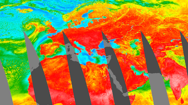
AMSR-E Brightness Temperature (89H GHz B Scan, Day), 2003-05-07
The (AMSR-E) instrument on the NASA Earth Observing System (EOS) Aqua satellite provides global passive microwave measurements of terrestrial, oceanic, and atmospheric variables for the investigation of global water and energy cycles. The AMSR-E Level-2A product (AE_L2A) contains horizontally and vertically polarized brightness temperature measurements at 6.9 GHz, 10.7 GHz, 18.7 GHz, 23.8 GHz, 36.5 GHz, and 89.0 GHz. The GIBS and AMSR-E team have selected the 89.0 GHz horizontal and vertical parameters for visualization. These measurements provide the highest level of data resolution from the available scan channels. More information can be found here.
MEaSUREs Freeze/Thaw

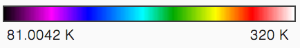
Key: Blue = Frozen. Red = Thawed, Olive = Transitional, Bright Green = Inverse Transitional
MEaSUREs Daily Landscape Freeze/Thaw, SSM/I-SSMR, 2004-02-24
MEaSUREs (Making Earth System Data Records for Use in Research Environments) products are generally created by linking together multiple satellites into a constellation, creating a longer-running, consistent data record. The MEaSUREs Freeze/Thaw product is a Global Record of Daily Landscape Freeze/Thaw created from a Scanning Multichannel Microwave Radiometer (SMMR) and Special Sensor Microwave/Imager (SSM/I) record for the years 1979 to 2010; and an Advanced Microwave Scanning Radiometer - Earth Observing System (AMSR-E) record for the years 2002 to 2011. The goal of the product is to quantify global vegetated land surface freeze/thaw state dynamics over a long-term data record of more than 25 years. More information can be found here and here.
Overview
Content Tools