Blog from April, 2014
search
attachments
weblink
advanced
Overview
Content Tools
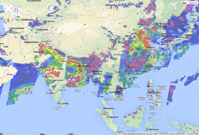
MODIS Aerosol Optical Depth mashed with Google Maps
The GIBS team is pleased to announce the availability of imagery in the Web Mercator / Google Maps / EPSG:3857 / EPSG:900913 map projection in addition to the already-supported Geographic (EPSG:4326), Arctic Polar Stereographic (EPSG:3413), and Antarctic Polar Stereographic (EPSG:3031) projections. This now enables integration of GIBS imagery with widely-used maps such as Google Maps, Bing Maps, and OpenStreetMap up to zoom level 9.
We've updated our API documentation, GIBS Web Examples on GitHub, and live demos such as Leaflet, Google Maps, and Bing Maps. We look forward to seeing what you build!
Please note that currently the "leading edge" of new Web Mercator imagery is available 2-4 hours after the Geographic imagery is produced for a total latency of 5-9 hours from the time the satellites capture the imagery until it is available in GIBS. Please also note that zoom level 0 (the top tile) is not currently supported.
Questions or comments? Write us at support@earthdata.nasa.gov.
We are pleased to announce that two new sets of imagery products are now available in GIBS:
- Aqua / AMSR-E (Advanced Microwave Scanning Radiometer-EOS) Brightness Temperature consisting of
- MEaSUREs (Making Earth System Data Records for Use in Research Environments) Global Record of Daily Landscape Freeze/Thaw consisting of
These products mark two milestones for the GIBS project:
- Imagery has been visualized and is available for every day throughout the entire MEaSUREs Freeze/Thaw and AMSR-E Brightness Temperature mission. Most of the other products in GIBS do not yet contain imagery from the entire mission duration.
- The Freeze/Thaw product is the first of many MEaSUREs datasets to be visualized and made available through GIBS.
More details regarding these products are found below:
Aqua / AMSR-E Brightness Temperature
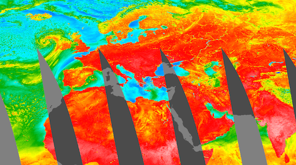
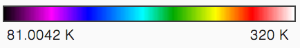
AMSR-E Brightness Temperature (89H GHz B Scan, Day), 2003-05-07
The (AMSR-E) instrument on the NASA Earth Observing System (EOS) Aqua satellite provides global passive microwave measurements of terrestrial, oceanic, and atmospheric variables for the investigation of global water and energy cycles. The AMSR-E Level-2A product (AE_L2A) contains horizontally and vertically polarized brightness temperature measurements at 6.9 GHz, 10.7 GHz, 18.7 GHz, 23.8 GHz, 36.5 GHz, and 89.0 GHz. The GIBS and AMSR-E team have selected the 89.0 GHz horizontal and vertical parameters for visualization. These measurements provide the highest level of data resolution from the available scan channels. More information can be found here.
MEaSUREs Freeze/Thaw

Key: Blue = Frozen. Red = Thawed, Olive = Transitional, Bright Green = Inverse Transitional
MEaSUREs Daily Landscape Freeze/Thaw, SSM/I-SSMR, 2004-02-24
MEaSUREs (Making Earth System Data Records for Use in Research Environments) products are generally created by linking together multiple satellites into a constellation, creating a longer-running, consistent data record. The MEaSUREs Freeze/Thaw product is a Global Record of Daily Landscape Freeze/Thaw created from a Scanning Multichannel Microwave Radiometer (SMMR) and Special Sensor Microwave/Imager (SSM/I) record for the years 1979 to 2010; and an Advanced Microwave Scanning Radiometer - Earth Observing System (AMSR-E) record for the years 2002 to 2011. The goal of the product is to quantify global vegetated land surface freeze/thaw state dynamics over a long-term data record of more than 25 years. More information can be found here and here.
The GIBS team is pleased to announce the operational deployment of the latest version of the OnEarth imagery access software, version 0.2.5. Source code and installation RPMs are available through the OnEarth GitHub repository The GIBS team has performed both functional and performance tests against this release in preparation for this deployment. The highlighted enhancements included in this release are listed below:
- WMTS and TWMS key-value pair URL parameters may now be supplied in any order and the keys are case insensitive.
- The WMTS and TWMS 'format' parameter may contain either an escaped ('%2F') or non-escaped ('/') backslash when specifying the image format (e.g. 'image/png').
- Enhanced error handling has been added for invalid requests to better assist GIBS client developers and image consumers in identify invalid image request URLs. More details are available on OnEarth GitHub wiki.
For questions regarding this release or other GIBS-related topics, please contact the GIBS team at support@earthdata.nasa.gov.
Stay tuned for more announcements in the coming week for new products and imagery projections.
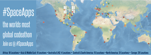
NASA's Global Imagery Browse Services (GIBS) will be participating in the 2014 International Space Apps Challenge, a global hack-a-thon to build open source solutions to space- and Earth-related needs over the weekend of April 11-13. NASA is organizing the event in collaboration with other government agencies and local organizations. Over the course of 48 hours, teams collaborating in cities and virtually will compete to build the best solutions to one of 40 challenges. Winners from each location will be judged locally; those winners will then be evaluated against each other globally in five categories: Best Use of Hardware, Best Use of Data, Most Inspiring, Galactic Impact, Best Mission Concept.
GIBS is providing three of the challenges for participants to address:
- A Picture is Worth a Thousand Words: build a mashup which integrates NASA imagery with data sets of your choice to tell a compelling story and allow others to interactively explore it.
- Animate Your World: build a cloud-free animation, share a satellite story, or knock our socks off! Using the GIBS API, build a web or mobile app which uses NASA imagery to show our planet in motion.
- Image-ine Earth Yesterday and Today: dream big! Considering the imagery that's available now and in the future, sketch out a prototype which uses GIBS to do something new.
We'll be online to answer questions to the above challenges along with participating in person at the Washington, DC / Baltimore location. We hope to see you there or online!