![]()
What is Zarr:
Zarr is one of these relatively newly adopted data formats specifically for N-Dimensional arrays. It is an effective way to store large N-dimensional data in the cloud and access chunks. Zarr can be viewed as the cloud based version of NetCDF files. Zarr does not come in a single file as NetCDF or HDF5 does but as a directory with chunks of data in compressed files and metadata in JSON files.
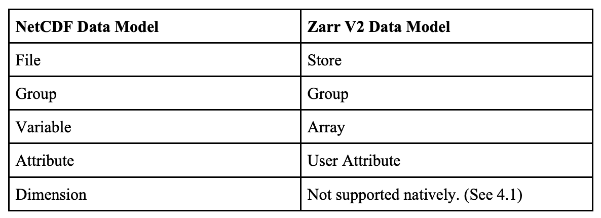
The semantic mapping from the NetCDF Data Model to Zarr Data Model is as follows:
A Zarr array can be stored in any storage system that provides a key/value interface, where a key is an ASCII string and a value is an arbitrary sequence of bytes, and the supported operations are read (get the sequence of bytes associated with a given key), write (set the sequence of bytes associated with a given key) and delete (remove a key/value pair).
Zarr V2 is the current stable version, Zarr V3 is considered experimental.
How does GeoZarr differ:
Zarr is a generic data format for Scientific Array Data. There is a GeoZarr Specification to provide a geospatial extension to the Zarr data format. GeoZarr can store multidimensional georeferenced earth observation data.
What is a Zarr (or GeoZarr) file organized:
With Zarr, Multiple arrays can be organized in hierarchies of groups. These arrays have the metadata as well as the actual chunked data. The .zarray describes how these binaries are encoded by giving unique key representations.

What support of the Zarr format exist:
Creating and using Zarr data files at this time appears to be most well supported using one of these methods:
1.) The primary implementation of Zarr format is the Python implementation (https://zarr.readthedocs.io/en/stable/),
2.) A Java implementation also is available (https://jzarr.readthedocs.io/en/latest/).
3.). There is also support within the gdal libraries: https://gdal.org/drivers/raster/zarr.html
4.). The R statistics package can also read Zarr files: https://r-spatial.org/r/2022/09/13/zarr.html
Are other standards groups looking at Zarr:
The Open Geospatial Consortium approved Zarr V2 as a community standard (https://www.ogc.org/standards/community) in June 2022. The documentation can be view at: https://portal.ogc.org/files/100727
Are data providers using Zarr:
Overview
Content Tools