Page History
| Note | ||
|---|---|---|
| ||
This page has been moved to https://nasa-gibs.github.io/gibs-api-docs/. Please update your bookmarks. This page will redirect in about 5 seconds. |
| Redirect | ||||||
|---|---|---|---|---|---|---|
|
| Table of Contents | ||
|---|---|---|
|
Overview
The Global Imagery Browse Services (GIBS) are designed to deliver global, full-resolution satellite imagery to users in a highly responsive manner, enabling interactive exploration of the Earth. To achieve that interactivity, GIBS first ingests imagery from a given NASA data provider on a continuous basis, creates a global mosaic of that imagery, then chops the mosaic into an image tile pyramid (see figure
below). By
pre-generating these tiles, it relieves the servers of image rescaling and cropping duties, greatly reducing computational overhead and enabling a highly responsive system. This also means that the primary method of imagery retrieval for clients is tile-based. For more background on how tiled web maps work, see the MapBox Developers Guide.
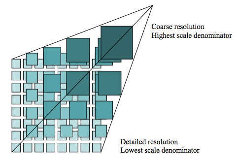
An image tile pyramid (
from OGC WMTS 1.0.0 specification)
While the requests made to GIBS are for individual tiles, users generally work at a higher level and configure a a map library, GIS client, or or script to determine which tiles to retrieve. These clients and scripts need to know which which products are available, which map projections are available, and how many zoom levels they support. GIBS provides this access through four five mechanisms:
- an Open Geospatial Consortium (OGC) Web Map Tile Service (WMTS) which also serves as a RESTful XYZ tile service which supports key-value-pair and RESTful tiled requests
- an Open Geospatial Consortium (OGC) Web Map Service (WMS) which supports a key-value-pair non-tiled requests
- a Tiled Web Map Service (TWMS), an unofficial extension to the OGC Web Map Service (WMS) where only , which supports key-value-pair tiled requests that match the exact geographic tile boundaries will be honoredon-demand generation of Google Earth KML files
- script-level access through the the Geospatial Data Abstraction Library (GDAL)
The implementation of these services is built from the long-running "OnEarth" server system at NASA/JPL.
Access to GIBS via OGC WMTS, Tiled OGC WMS, Tiled WMS, KML files, and GDAL is described below.
In addition, source code for the GIBS tiled imagery server and tiled imagery storage format is available. See this blog post for more info along with the code on GitHub.
Layer Configuration Information
In the list of available GIBS products, note that there are columns for "Projection(s)" and "Resolution". The currently available projections are:
- Lat-lon / Geographic / WGS 84 (EPSG:4326)
- Web Mercator / Spherical Mercator / "Google Projection" (EPSG:3857)
- NSIDC Sea Ice Polar Stereographic North (EPSG:3413)
- Antarctic Polar Stereographic / WGS 84 (EPSG:3031)
Not all products are generated in all projections, though most products are available in at least "lat-lon" and Web Mercator. See the GIBS available product list to determine which projections are supported for each product. Please also note that there is a 1-4 hour delay in processing incoming imagery in the Web Mercator projection compared to that in the lat-lon / geographic projection.
For each of those projections, a certain number of zoom levels are available for each product. Again, the product list shows the maximum resolution available for each product. See below for a mapping of resolutions to zoom levels for each projection. This information can be used to configure your map client to work with GIBS.
For reference, the area/extent displayed in the polar projections were selected to a) cover the main land/ice masses at each pole and b), to ensure that the full resolution image has a resolution and pixel height/width that are a power of two as required by our tiled imagery storage system.
WGS 84 / Lat-lon / Geographic (EPSG:4326)
Resolution (per pixel) | Tile Matrix Set (WMTS) | # Zoom Levels | Max Resolution (deg/pixel) | Min Resolution (deg/pixel) |
|---|---|---|---|---|
| 31.25m | 31.25m | 12 | 0.5625 | 0.000274658203125 |
| 250m | 250m | 9 | 0.5625 | 0.002197265625 |
| 500m | 500m | 8 | 0.5625 | 0.00439453125 |
| 1km | 1km | 7 | 0.5625 | 0.0087890625 |
| 2km | 2km | 6 | 0.5625 | 0.017578125 |
Lat-lon / Geographic / WGS 84 (EPSG:4326)
Web Mercator (EPSG:3857)
Resolution (per pixel) | Tile Matrix Set (WMTS) | # Zoom Levels | Max Resolution (m/pixel) | Min Resolution (m/pixel) |
|---|---|---|---|---|
305.7481131407048m | GoogleMapsCompatible_Level9 | 9 | 156543.03390625 | 305.7481131407048 |
611.4962262814100m | GoogleMapsCompatible_Level8 | 8 | 156543.03390625 | 611.4962262814100 |
1222.992452562820m | GoogleMapsCompatible_Level7 | 7 | 156543.03390625 | 1222.992452562820 |
2445.984905125640m | GoogleMapsCompatible_Level6 | 6 | 156543.03390625 | 2445.984905125640 |
Please note that the "top tile" (i.e., zoom level 0) is not currently supported by GIBS.
Web Mercator / Spherical Mercator / "Google Projection" (EPSG:3857)
NSIDC Sea Ice Polar Stereographic North (EPSG:3413)
Resolution (per pixel) | Tile Matrix Set (WMTS) | # Zoom Levels | Max Resolution (m/pixel) | Min Resolution (m/pixel) |
|---|---|---|---|---|
| 250m | 250m | 6 | 8192.0 | 256.0 |
| 500m | 500m | 5 | 8192.0 | 512.0 |
| 1km | 1km | 4 | 8192.0 | 1024.0 |
| 2km | 2km | 3 | 8192.0 | 2048.0 |

NSIDC Sea Ice Polar Stereographic North (EPSG:3413)
Antarctic Polar Stereographic (EPSG:3031)
Resolution (per pixel) | Tile Matrix Set (WMTS) | # Zoom Levels | Max Resolution (deg/pixel) | Min Resolution (deg/pixel) |
|---|---|---|---|---|
| 250m | 250m | 6 | 8192.0 | 256.0 |
| 500m | 500m | 5 | 8192.0 | 512.0 |
| 1km | 1km | 4 | 8192.0 | 1024.0 |
| 2km | 2km | 3 | 8192.0 | 2048.0 |
Antarctic Polar Stereographic / WGS 84 (EPSG:3031)
Imagery Layers & Endpoints
GIBS imagery layers are named and made available through a set of defined endpoints based on the following characteristics:
- Projection & Resolution - Imagery layers are available in one or more projected coordinate systems (e.g. EPSG:4326 - "Geographic Lat/Lon") at a specific resolution (e.g. 2km/pixel)
- Near Real-Time vs Standard Latency - Imagery layers are available in a near real-time (e.g. within 3 hours of observation) or standard (e.g. within X days of observation) latency.
- Data Version - Imagery layers may be available for more than one version (e.g. MODIS v5 and v6) of the same science parameter.
You will note in the list of available GIBS products, that there are columns for "Projection(s)" and "Resolution", which correspond to the information provided below. GIBS services additionally provide machine-readable documents (e.g. WMTS "Get Capabilities") that provide specific information regarding all available imagery layers.
For GIBS service endpoints, additional DNS entries are available as a way to circumvent simultaneous connection limits of the web browser (as described here ). The additional DNS entries are https://gibs-a.earthdata.nasa.gov, https://gibs-b.earthdata.nasa.gov, and https://gibs-c.earthdata.nasa.gov. Please note that these are not additional servers, simply aliases for the https://gibs.earthdata.nasa.gov domain.
The remainder of this section provides additional details regarding how GIBS imagery layers are named and made available through service endpoints. These details provide a thorough description of the available configurations of the GIBS imagery layers. Outside of this section, this page will reference only the "Best Available" imagery layers and endpoints, described below, for simplicity.
Layer Naming
GIBS imagery layer identifiers follow a human-readable convention (e.g. MODIS_Terra_Aerosol_Optical_Depth_v6_STD) to simplify situations where manual parsing of service documentation (e.g. WMTS GetCapabilities) is performed. Identifiers include uniquely identifying information like the following items:
- Instrument/Platform - The Instrument and Platform responsible for collecting the visualized data (e.g. "MODIS / Terra").
- Science Parameter - The science parameter that is being visualized (e.g. "Aerosol Optical Depth")
- Processing Level - The processing level of the associated data (e.g. "L3" or "L2")
- Data Period - The period of the available imagery products (e.g. "Monthly")
- Data Version - The version of the associated data product (e.g. "v6")
- Data Latency - The latency of the associated data product (e.g. "STD" or "NRT")
The following are examples of imagery layer identifiers for the "Aerosol Optical Depth" science parameter collected by the MODIS instrument on the Terra platform. In this example, imagery layers exist for a combination of data versions and latencies. The first item is considered the "Best Available" layer, which is described further in the following section.
Example layer names are listed below:
- MODIS_Terra_Aerosol_Optical_Depth
- MODIS_Terra_Aerosol_Optical_Depth_v6_NRT
- MODIS_Terra_Aerosol_Optical_Depth_v6_STD
- MODIS_Terra_Aerosol_Optical_Depth_v5_NRT
"Best Available" Layers
As has been discussed, imagery layers visualizing the same science parameter from a specific instrument and platform may be available for multiple versions and/or data latencies. Direct access to those various flavors of the same visualization are directly available. However, many users are simply interested in seeing a consistent "best available" imagery layer. The details of what is "best" being determined by the GIBS team. Therefore, GIBS provides a unique set of "Best Available" imagery layers for all of its imagery layers, abstracting away the individual versions and latencies. A similar naming convention is used, as described in the previous section, but identifiers do not specify the version or latency (e.g. MODIS_Terra_Aerosol_Optical_Depth).
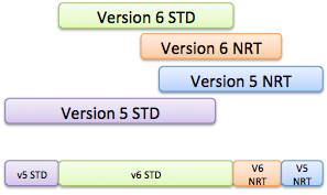
For each "best available" layer, the "best" image will be determined based on the evaluation of availability for following imagery products:
See the image to the right for a visual example. The top four bars show the temporal coverage of related imagery products. The bottom bar shows the imagery products that will be returned based on the "best available" determination. |
Time → |
Projections & Resolution
GIBS supports imagery products in the following projections. In order to facilitate the pre-generation of tiled imagery, GIBS has selected a set of resolutions within each projection.
- EPSG:4326 - Lat-lon / Geographic / WGS 84
- EPSG:3857 - Web Mercator / Spherical Mercator / "Google Projection"
- EPSG:3413 - NSIDC Sea Ice Polar Stereographic North
- EPSG:3031 - Antarctic Polar Stereographic / WGS 84
When developing new imagery layers, GIBS works with the imagery providers to determine the "appropriate" projections and resolution. The following guidelines will help you access these layers:
- Imagery layers may not be available in all projections.
- Imagery layers available in multiple projections utilize the same identifiers.
- Imagery layers available in the EPSG:4326, EPSG:3413, and EPSG:3031 projections are provided at the same resolution.
- Imagery layers available in the EPSG:4326 "Geographic" projection are available in the EPSG:3857 "Web Mercator" projection.
- Note: Some of the non-data (e.g. coastlines, land mask) may not be available in EPSG:3857.
For each projection and resolution, a certain number of zoom levels are available for tiled access services (i.e. WMTS and TWMS). Each zoom level corresponds to a "power of 2" zoom in/out from the previous/next level. This information can be used to configure your map client to work with GIBS. Note that the GIBS spatial coverage of the Geographic and Web Mercator projections match the full extent of the projections, as defined by the EPSG. The GIBS spatial coverages of the north and south polar projections are a subset of the full projection extent, as defined by the EPSG. The GIBS' extents were selected to a) cover the main land/ice masses at each pole and b), to ensure that the full resolution image has a resolution and pixel height/width that are a power of two as required for tiled access and zooming.
The following subsections provide additional information regarding the GIBS projections and their available resolutions:
WGS 84 / Lat-lon / Geographic (EPSG:4326)
Resolution (per pixel) | Tile Matrix Set (WMTS) | # Zoom Levels | Max Resolution (deg/pixel) | Min Resolution (deg/pixel) |
|---|---|---|---|---|
| 15.125m | 15.125m | 13 | 0.5625 | 0.0001373291015625 |
31.25m | 31.25m | 12 | 0.5625 | 0.000274658203125 |
250m | 250m | 9 | 0.5625 | 0.002197265625 |
500m | 500m | 8 | 0.5625 | 0.00439453125 |
1km | 1km | 7 | 0.5625 | 0.0087890625 |
2km | 2km | 6 | 0.5625 | 0.017578125 |
Lat-lon / Geographic / WGS 84 (EPSG:4326)
Web Mercator (EPSG:3857)
Resolution (per pixel) | Tile Matrix Set (WMTS) | # Zoom Levels | Max Resolution (m/pixel) | Min Resolution (m/pixel) |
|---|---|---|---|---|
| 19.10925707129405 m | GoogleMapsCompatible_Level13 | 13 | 156543.03390625 | 19.10925707129405 |
| 38.21851414258810 m | GoogleMapsCompatible_Level12 | 12 | 156543.03390625 | 38.21851414258810 |
305.7481131407048 m | GoogleMapsCompatible_Level9 | 9 | 156543.03390625 | 305.7481131407048 |
611.4962262814100 m | GoogleMapsCompatible_Level8 | 8 | 156543.03390625 | 611.4962262814100 |
1222.992452562820 m | GoogleMapsCompatible_Level7 | 7 | 156543.03390625 | 1222.992452562820 |
2445.984905125640 m | GoogleMapsCompatible_Level6 | 6 | 156543.03390625 | 2445.984905125640 |
Web Mercator / Spherical Mercator / "Google Projection" (EPSG:3857)
NSIDC Sea Ice Polar Stereographic North (EPSG:3413)
Resolution (per pixel) | Tile Matrix Set (WMTS) | # Zoom Levels | Max Resolution (m/pixel) | Min Resolution (m/pixel) |
|---|---|---|---|---|
250m | 250m | 6 | 8192.0 | 256.0 |
500m | 500m | 5 | 8192.0 | 512.0 |
1km | 1km | 4 | 8192.0 | 1024.0 |
2km | 2km | 3 | 8192.0 | 2048.0 |
NSIDC Sea Ice Polar Stereographic North (EPSG:3413)
Antarctic Polar Stereographic (EPSG:3031)
Resolution (per pixel) | Tile Matrix Set (WMTS) | # Zoom Levels | Max Resolution (deg/pixel) | Min Resolution (deg/pixel) |
|---|---|---|---|---|
250m | 250m | 6 | 8192.0 | 256.0 |
500m | 500m | 5 | 8192.0 | 512.0 |
1km | 1km | 4 | 8192.0 | 1024.0 |
2km | 2km | 3 | 8192.0 | 2048.0 |
Antarctic Polar Stereographic / WGS 84 (EPSG:3031)
Service Endpoints
GIBS imagery layers are made available through standard access methods, described in a following section of this page. Where applicable, those services have multiple "endpoints" that contain a specific set of GIBS imagery layers. The endpoints are scoped using the following items:
- Service - Either the WMTS, WMS, or TWMS specification.
- Projection - The EPSG code for the appropriate projection.
- Type - The "type" of imagery layers available in the endpoint. Valid values include:
- best - The "Best Available" imagery products.
- std - Standard imagery products only.
- nrt - Near Real-Time imagery products only.
- all - All Best Available, Standard, and Near Real-Time imagery products.
The pattern for a GIBS service endpoint is shown below. Parameterized elements of the pattern are provided in \{paramter:value1[|value2]*\} notation.
https://gibs.earthdata.nasa.gov/{service:wmts|wms|twms}/epsg{code:4326|3857|3413|3031}/{type:all|best|nrt|std}The following table provides some sample endpoints for various unique combinations:
Service | EPSG | Type | Sample Endpoint |
|---|---|---|---|
WMTS | 4326 | all | https |
OGC Web Map Tile Service (WMTS)
The Open Geospatial Consortium (OGC) Web Map Tile Service (WMTS) provides a way for clients to retrieve tiled mapping data in a standardized manner, handling product-specific details such as available number of zoom levels, map projections, image formats, tile sizes, etc. The WMTS specification provides guidance for three methods of tile retrieval: Key-Value Pair (KVP), REpresentational State Transfer (REST), and Simple Object Access Protocol (SOAP). GIBS supports KVP and REST.
Service Endpoints and GetCapabilities
The WMTS specification requires that a WMTS server provide information regarding the available imagery via a GetCapabilities request. Here is a list of available service endpoints, projections, and their GetCapabilities request:
WGS 84 / Geographic - EPSG:4326, WMTS version 1.0.0- KVP endpoint: http://gibs.earthdata.nasa.gov/wmts/epsg3857/best/wmts.cgi
- KVP GetCapabilities: http://gibs.earthdata.nasa.gov/wmts/epsg3857/best/wmts.cgi?SERVICE=WMTS&request=GetCapabilities
- REST endpoint: http://gibs.earthdata.nasa.gov/wmts/epsg3857/best/
- REST GetCapabilities: http://gibs.earthdata.nasa.gov/wmts/epsg3857/best/1.0.0/WMTSCapabilities.xml
- Arctic polar stereographic - EPSG:3413, WMTS version 1.0.0
- KVP endpoint: http://gibs.earthdata.nasa.gov/wmts/epsg3413/best/wmts.cgi
- KVP GetCapabilities: http://gibs.earthdata.nasa.gov/wmts/epsg3413/best/wmts.cgi?SERVICE=WMTS&request=GetCapabilities
- REST endpoint: http://gibs.earthdata.nasa.gov/wmts/epsg3413/best/
- REST GetCapabilities: http://gibs.earthdata.nasa.gov/wmts/epsg3413/best/1.0.0/WMTSCapabilities.xml
- Antarctic polar stereographic - EPSG:3031, WMTS version 1.0.0
- KVP endpoint: http://gibs.earthdata.nasa.gov/wmts/epsg3031/best/wmts.cgi
- KVP GetCapabilities: http://gibs.earthdata.nasa.gov/wmts/epsg3031/best/wmts.cgi?SERVICE=WMTS&request=GetCapabilities
- REST endpoint: http://gibs.earthdata.nasa.gov/wmts/epsg3031/best/
- REST GetCapabilities: http://gibs.earthdata.nasa.gov/wmts/epsg3031/best/1.0.0/WMTSCapabilities.xml
Time Dimension
The core concept within the GetCapabilities response is an imagery layer. The GIBS tiled imagery provides a unique global image per day per layer. Therefore, the layer definition within the GIBS GetCapabilities response must address a time dimension. The GIBS team has chosen to address this in the following manner, within each layer:
<Dimension>
   <ows:Identifier>time</ows:Identifier>
   <UOM>ISO8601</UOM>
   <Default>2013-05-29</Default>
   <Current>true</Current>
   <Value>2012-05-08/2013-05-29/P1D</Value>
</Dimension>
(Note: “2013-05-29” will be replaced by the current UTC date.)
The parts of the Dimension data structure are taken from the WMTS 1.0.0 spec (Table 9, p. 22). However, since the WMTS spec doesn't address the time dimension (other than the use of "Current"), we are adapting some aspects of the WMS spec regarding the time dimension, specifically:
- The contents of the <UOM> part match the contents of the "units=" attribute in the WMS <Dimension> element.
- The contents of the <Value> part match the contents of the WMS <Extent> element.
If the time dimension is omitted in the WMTS request, tiles for the current UTC date will be returned. Be aware that many of the current date’s tiles will be empty because the imagery is generated as the satellites orbit from east to west.
Sample Execution
GIBS has chosen to implement the Key-Value Pair and RESTful service interfaces. Equivalent sample requests are included below:
KVP - http://gibs.earthdata.nasa.gov/wmts/epsg4326/best/wmts.cgi?SERVICE=WMTS&REQUEST=GetTile&VERSION=1.0.0&LAYER=MODIS_Terra_CorrectedReflectance_TrueColor&STYLE=&TILEMATRIXSET=250m&TILEMATRIX=6&TILEROW=13&TILECOL=36&FORMAT=image%2Fjpeg&TIME=2012-07-09RESTful - http
://gibs.earthdata.nasa.gov/wmts/epsg4326/all/ | ||
WMS | 3857 | best |
More generically, the RESTful request follows the form of:
https://gibs.earthdata.nasa.gov/wms/epsg3857/best/ | |||
TWMS | 3413 | nrt | https |
://gibs.earthdata.nasa.gov/ |
twms/epsg3413/nrt/ |
Imagery API/Services
OGC Web Map Tile Service (WMTS)
The Open Geospatial Consortium (OGC) Web Map Tile Service (WMTS) provides a way for clients to retrieve tiled mapping data in a standardized manner, handling product-specific details such as available number of zoom levels, map projections, image formats, tile sizes, etc. The WMTS specification provides guidance for three methods of tile retrieval: Key-Value Pair (KVP), REpresentational State Transfer (REST), and Simple Object Access Protocol (SOAP). GIBS supports KVP and REST, but not SOAP.
Service Endpoints and GetCapabilities
The WMTS specification requires that a WMTS server provide information regarding the available imagery via a GetCapabilities request. Here is a list of available service endpoints, projections, and their GetCapabilities request:
- WGS 84 / Geographic - EPSG:4326, WMTS version 1.0.0
- KVP endpoint: https://gibs.earthdata.nasa.gov/wmts/epsg4326/best/wmts.cgi
- KVP GetCapabilities: https://gibs.earthdata.nasa.gov/wmts/epsg4326/best/wmts.cgi?SERVICE=WMTS&request=GetCapabilities
- REST endpoint: https
- WGS 84 / Geographic - EPSG:4326, WMTS version 1.0.0
Example Clients
Generic XYZ Tile Access
The WMTS RESTful interface above can be easily adapted for use as a "generic" XYZ tile server if the developer pre-populates all of the required fields except the tile row, column, and zoom level. For example, by starting with the most generalized GIBS API request:
Populating the fields with the desired projection, product, time, etc (Terra/MODIS Aerosol Optical depth from 2014/04/09, in this case), GIBS products can be used by clients such as ESRI's ArcGIS Online to add a "Tile Layer" by leaving the row, column, and zoom level as parameters:
httpepsg3857MODIS_Terra_Aerosol/default/2014-04-09/GoogleMapsCompatible_Level6/{level}/{row}/{col}.pngTiled Web Map Service (TWMS)
Tiled WMS offers fast response to a limited number of WMS access patterns - specifically those access patterns which provide geographic bounds which fall along the edges of pregenerated tiles.
Those patterns are described in the TWMS GetTileService request. The response is an XML encoded list of available WMS access patterns. A TiledPattern access pattern is a set gridded WMS requests, where parameter order, case and content are constant, with the exception of the bbox values. Using this pattern allows fast access to tiles for a given combination of layers and associated styles at a given resolution over a defined area. All the information about a pattern can be extracted form the provided WMS call, using these rules:
Server prefix is defined in the OnlineResource tag Area covered is defined in the LatLonBoundingBox Tile size is provided by the widthand height parameters values Tile format is provided by the format parameter value Tile coverage can be computed as (Lon1-Lon0)and (Lat1-Lat0), where Lon1,Lon0,Lat1 and Lat0 are the arguments of the bbox parameter. The Grid alignment results from the bboxargument and the tile coverage. The bbox argument values provided in the pattern are for the top-left tile, the other tile locations can be computed based on the tile coverage. Other metadata that might be of interest to a user is contained in the Name, Title andAbstract tags.
Multiple WMS patterns in a single TilePattern are equivalent. TilePattern tags that have something in common are grouped in a hierarchical structure build using TiledGroup tags. The innermost level refers to the same exact data, possible differences being the image size, image format, resolution, and alignment. Higher level TiledGroup are used to group together related datasets.
- REST GetCapabilities: https://gibs.earthdata.nasa.gov/wmts/epsg4326/best/1.0.0/WMTSCapabilities.xml
- Web Mercator - EPSG:3857, WMTS version 1.0.0
- KVP endpoint: https://gibs.earthdata.nasa.gov/wmts/epsg3857/best/wmts.cgi
- KVP GetCapabilities: https://gibs.earthdata.nasa.gov/wmts/epsg3857/best/wmts.cgi?SERVICE=WMTS&request=GetCapabilities
- REST endpoint: https://gibs.earthdata.nasa.gov/wmts/epsg3857/best/
- REST GetCapabilities: https://gibs.earthdata.nasa.gov/wmts/epsg3857/best/1.0.0/WMTSCapabilities.xml
- Arctic polar stereographic - EPSG:3413, WMTS version 1.0.0
- KVP endpoint: https://gibs.earthdata.nasa.gov/wmts/epsg3413/best/wmts.cgi
- KVP GetCapabilities: https://gibs.earthdata.nasa.gov/wmts/epsg3413/best/wmts.cgi?SERVICE=WMTS&request=GetCapabilities
- REST endpoint: https://gibs.earthdata.nasa.gov/wmts/epsg3413/best/
- REST GetCapabilities: https://gibs.earthdata.nasa.gov/wmts/epsg3413/best/1.0.0/WMTSCapabilities.xml
- Arctic polar stereographic - EPSG:3413, WMTS version 1.0.0
- Antarctic polar stereographic - EPSG:3031, WMTS version 1.0.0
- KVP endpoint: https://gibs.earthdata.nasa.gov/wmts/epsg3031/best/wmts.cgi
- KVP GetCapabilities: https://gibs.earthdata.nasa.gov/wmts/epsg3031/best/wmts.cgi?SERVICE=WMTS&request=GetCapabilities
- REST endpoint: https://gibs.earthdata.nasa.gov/wmts/epsg3031/best/
- REST GetCapabilities: https://gibs.earthdata.nasa.gov/wmts/epsg3031/best/1.0.0/WMTSCapabilities.xml
- Antarctic polar stereographic - EPSG:3031, WMTS version 1.0.0
Time Dimension
The core concept within the GetCapabilities response is a map layer. GIBS map layers represent data that changes over time, most commonly providing a different map each day. Therefore, the layer definition within the GIBS GetCapabilities response must present a time dimension. The GIBS team has chosen to address this in the following manner, within each layer:
<Dimension>
   <ows:Identifier>time</ows:Identifier>
   <UOM>ISO8601</UOM>
   <Default>2013-05-29</Default>
   <Current>false</Current>
   <Value>2012-05-08/2013-05-29/P1D</Value>
</Dimension>
The parts of the Dimension data structure are taken from the WMTS 1.0.0 spec (Table 9, p. 22). However, since the WMTS spec doesn't address the time dimension, we are adapting some aspects of the WMS spec regarding the time dimension, specifically:
- The contents of the <UOM> part match the contents of the "units=" attribute in the WMS <Dimension> element.
- The contents of the <Value> part match the contents of the WMS <Extent> element.
If the time dimension is omitted in the WMTS request, GIBS will return tiles for the default date, as specified in the <Default> tag. Note that GIBS' imagery layers all have a value of false in the <Current> tag which means that the special current keyword cannot be provided as the time value. However, GIBS does support use of the special default keyword, which results in the same response as though the date were omitted.
Sample Execution
GIBS has chosen to implement the Key-Value Pair and RESTful service interfaces. Equivalent sample requests are included below:
- KVP - https://gibs.earthdata.nasa.gov/wmts/epsg4326/best/wmts.cgi?SERVICE=WMTS&REQUEST=GetTile&VERSION=1.0.0&LAYER=MODIS_Terra_CorrectedReflectance_TrueColor&STYLE=&TILEMATRIXSET=250m&TILEMATRIX=6&TILEROW=13&TILECOL=36&FORMAT=image%2Fjpeg&TIME=2012-07-09
- RESTful - https://gibs.earthdata.nasa.gov/wmts/epsg4326/best/MODIS_Terra_CorrectedReflectance_TrueColor/default/2012-07-09/250m/6/13/36.jpg
More generically, the RESTful request follows the form of:
- https://gibs.earthdata.nasa.gov/wmts/epsg{EPSG:Code}/best/{ProductName}/default/{Time}/{TileMatrixSet}/{ZoomLevel}/{TileRow}/{TileCol}.png
Example Clients
Generic XYZ Tile Access
The WMTS RESTful interface above can be easily adapted for use as a "generic" XYZ tile server if the developer pre-populates all of the required fields except the tile row, column, and zoom level. For example, by starting with the most generalized GIBS API request:
Populating the fields with the desired projection, product, time, etc (Terra/MODIS Aerosol Optical depth from 2014/04/09, in this case), GIBS products can be used by clients such as ESRI's ArcGIS Online to add a "Tile Layer" by leaving the row, column, and zoom level as parameters:
OGC Web Map Service (WMS)
The Open Geospatial Consortium (OGC) Web Map Service (WMS) provides a way for clients to receive a customized WMS response based on request parameters such as a custom bounding box, dimensions, layer(s) and format. Unlike the rigidity enforced through tiled interfaces (e.g. WMTS and TWMS), WMS responses are more flexible and may contain multiple composited layers in a single output. Two WMS specifications are currently available and supported by GIBS: 1.1.1 and 1.3.0. Both WMS specifications support a single method of image retrieval, which is supported by GIBS: Key-Value Pair (KVP).
Service Endpoints and GetCapabilities
The WMS specification requires that a WMS server provide information regarding the available imagery via a GetCapabilities request. Here is a list of available service endpoints, projections, and their GetCapabilities request:
- WGS 84 / Geographic - EPSG:4326
- WMS endpoint: https://gibs.earthdata.nasa.gov/wms/epsg4326/best/wms.cgi
- WMS v1.1.1 GetCapabilities: https://gibs.earthdata.nasa.gov/wms/epsg4326/best/wms.cgi?SERVICE=WMS&REQUEST=GetCapabilities&VERSION=1.1.1
- WMS v1.3.0 GetCapabilities: https://gibs.earthdata.nasa.gov/wms/epsg4326/best/wms.cgi?SERVICE=WMS&REQUEST=GetCapabilities&VERSION=1.3.0
- Web Mercator - EPSG:3857
- WMS endpoint: https://gibs.earthdata.nasa.gov/wms/epsg3857/best/wms.cgi
- WMS v1.1.1 GetCapabilities: https://gibs.earthdata.nasa.gov/wms/epsg3857/best/wms.cgi?SERVICE=WMS&REQUEST=GetCapabilities&VERSION=1.1.1
- WMS v1.3.0 GetCapabilities: https://gibs.earthdata.nasa.gov/wms/epsg3857/best/wms.cgi?SERVICE=WMS&REQUEST=GetCapabilities&VERSION=1.3.0
- WGS 84 / Geographic - EPSG:4326
- Arctic polar stereographic - EPSG:3413
- WMS endpoint: https://gibs.earthdata.nasa.gov/wms/epsg3413/best/wms.cgi
- WMS v1.1.1 GetCapabilities: https://gibs.earthdata.nasa.gov/wms/epsg3413/best/wms.cgi?SERVICE=WMS&REQUEST=GetCapabilities&VERSION=1.1.1
- WMS v1.3.0 GetCapabilities: https://gibs.earthdata.nasa.gov/wms/epsg3413/best/wms.cgi?SERVICE=WMS&REQUEST=GetCapabilities&VERSION=1.3.0
- Arctic polar stereographic - EPSG:3413
- Antarctic polar stereographic - EPSG:3031
- WMS endpoint: https://gibs.earthdata.nasa.gov/wms/epsg3031/best/wms.cgi
- WMS v1.1.1 GetCapabilities: https://gibs.earthdata.nasa.gov/wms/epsg3031/best/wms.cgi?SERVICE=WMS&REQUEST=GetCapabilities&VERSION=1.1.1
- WMS v1.3.0 GetCapabilities: https://gibs.earthdata.nasa.gov/wms/epsg3031/best/wms.cgi?SERVICE=WMS&REQUEST=GetCapabilities&VERSION=1.3.0
- Antarctic polar stereographic - EPSG:3031
| Note |
|---|
EPSG:3857 GetMap requests for vector-based visualizations may fail when using the Web Mercator WMS endpoint listed above. However, you may instead provide the "CRS=EPSG:3857" query parameter to the Geographic WMS endpoint. This affects the following GIBS visualization layers:
|
Time Dimension
The core concept within the GetCapabilities response is a map layer. GIBS map layers represent data that changes over time, most commonly providing a different map each day. Therefore, the layer definition within the GIBS GetCapabilities response must present a time dimension. The GIBS team has chosen to address this in the following manner, as outlined in the respective OGC WMS specification:
WMS v1.1.1
<Dimension name="time" units="ISO8601"/><Extent name="time" default="2018-11-14" nearestValue="1">2013-07-16/2018-11-14/P1D</Extent>WMS v1.3.0
<Dimension name="time" units="ISO8601" default="2018-10-01" nearestValue="1">2002-09-01/2018-10-01/P1M</Dimension>If the time dimension is omitted in the WMS request, GIBS will return tiles for the default date, as specified in the default attribute. Note that GIBS' imagery layers all have a value of 1 in the nearestValue tag indicating that GIBS will snap to the nearest time value within the specified dimension extents. Additionally, GIBS supports use of the special default keyword, which results in the same response as though the date were omitted.
Sample Execution
GIBS has chosen to implement the Key-Value Pair and RESTful service interfaces. Equivalent sample requests are included below:
- WMS v1.1.1 - https://gibs.earthdata.nasa.gov/wms/epsg4326/best/wms.cgi?SERVICE=WMS&REQUEST=GetMap&VERSION=1.1.1&LAYERS=MODIS_Terra_SurfaceReflectance_Bands721&STYLES=&FORMAT=image%2Fpng&TRANSPARENT=true&HEIGHT=256&WIDTH=256&TIME=2018-10-01&SRS=EPSG:4326&BBOX=-22.5,0,0,22.5
- WMS v1.3.0 - https://gibs.earthdata.nasa.gov/wms/epsg4326/best/wms.cgi?SERVICE=WMS&REQUEST=GetMap&VERSION=1.3.0&LAYERS=MODIS_Terra_SurfaceReflectance_Bands721&STYLES=&FORMAT=image%2Fpng&TRANSPARENT=true&HEIGHT=256&WIDTH=256&TIME=2018-10-01&CRS=EPSG:4326&BBOX=-22.5,0,0,22.5
Geographic Information System (GIS) Client Usage
Tiled Web Map Service (TWMS)
Tiled WMS offers fast response to a limited number of WMS access patterns - specifically those access patterns which provide geographic bounds which fall along the edges of pregenerated tiles.
Those patterns are described in the TWMS GetTileService request. The response is an XML encoded list of available WMS access patterns. A TiledPattern access pattern is a set gridded WMS requests, where parameter order, case and content are constant, with the exception of the bbox values. Using this pattern allows fast access to tiles for a given combination of layers and associated styles at a given resolution over a defined area. All the information about a pattern can be extracted form the provided WMS call, using these rules:
Server prefix is defined in the OnlineResource tag Area covered is defined in the LatLonBoundingBox Tile size is provided by the width and height parameters values Tile format is provided by the format parameter value Tile coverage can be computed as (Lon1-Lon0)and (Lat1-Lat0), where Lon1,Lon0,Lat1 and Lat0 are the arguments of the bbox parameter. The Grid alignment results from the bbox argument and the tile coverage. The bbox argument values provided in the pattern are for the top-left tile, the other tile locations can be computed based on the tile coverage. Other metadata that might be of interest to a user is contained in the Name, Title andAbstract tags.
Multiple WMS patterns in a single TilePattern are equivalent. TilePattern tags that have something in common are grouped in a hierarchical structure build using TiledGroup tags. The innermost level refers to the same exact data, possible differences being the image size, image format, resolution, and alignment. Higher level TiledGroup are used to group together related datasets.
A client application is expected to request this information only if it is defined as a request in the WMS server Capabilities. Once obtained, the application needs to analyze the patterns, decide which ones can be used and then issue only WMS requests that match the pattern to the normal WMS server, requests that can be built by modifying the bbox argument in a TiledPattern and prefixing the resulting string with the content of the OnlineResource tag.
The 'time' parameter follows the form YYYY-MM-DD which should be included in the request for a time-varying layer; if the time dimension is omitted in the TWMS request, tiles for the current UTC date will be returned. Be aware that many of the current date’s tiles will be empty because the imagery is generated as the satellites orbit from east to west.
Service Endpoints
- Geographic - EPSG:4326, TWMS version 0.1.0
Service endpoint: https://gibs.earthdata.nasa.gov/twms/epsg4326/best/twms.cgi
GetTileService request: https://gibs.earthdata.nasa.gov/twms/epsg4326/best/twms.cgi?request=GetTileService
- Geographic - EPSG:4326, TWMS version 0.1.0
- Arctic Polar Stereographic - EPSG:3413, TWMS version 0.1.0
- Service endpoint: https://gibs.earthdata.nasa.gov/twms/epsg3413/best/twms.cgi
- GetTileService request: https://gibs.earthdata.nasa.gov/twms/epsg3413/best/twms.cgi?request=GetTileService
- Arctic Polar Stereographic - EPSG:3413, TWMS version 0.1.0
- Antarctic Polar Stereographic - EPSG:3031, TWMS version 0.1.0
- Service endpoint: https://gibs.earthdata.nasa.gov/twms/epsg3031/best/twms.cgi
- GetTileService request: https://gibs.earthdata.nasa.gov/twms/epsg3031/best/twms.cgi?request=GetTileService
- Antarctic Polar Stereographic - EPSG:3031, TWMS version 0.1.0
Sample Execution
Vector Visualization Products
Overview
Vector products are accessible through the GIBS WMTS and WMS services. WMTS responses are formatted as gzip-compressed Mapbox vector tiles (specification), or "MVTs", while WMS responses are available as raster images. See the Access section below for more information.
The data behind each visualization service is the same, however the mechanism for styling differs. A client application is responsible for applying styling to MVTs when using the WMTS API. Conversely, GIBS applies a default style when rendering vector data as a raster when using the WMS API. See the Vector Layer Styles section below for more information.
An MVT returned via the WMTS service contains information for a client to draw the features within the user interface, but also a set of properties that contain data associated with the feature. The Mapbox vector tile specification provides structure for representing these data, but no mechanism for interpreting the meaning or intended use. As such, additional metadata is required. GIBS has developed a specification for defining each property contained within MVTs in its vector products. See the Vector Layer Metadata section below for more information.
| Anchor | ||||
|---|---|---|---|---|
|
Access
The following sections provide examples for how to detect and interact with vector products within the GIBS WMTS and WMS services
| Note |
|---|
Vector products are not natively provided in the EPSG:3857 projection through either the WMTS or WMS services. A workaround for WMS requests is to utilize the EPSG:4326 endpoint with EPSG:3857-based |
| UI Expand | |||||||||
|---|---|---|---|---|---|---|---|---|---|
| |||||||||
Accessing a vector product through the WMTS service follows the same rules as raster products. The primary differences being the format specified in the request and of the response. When issuing a KVP WMTS request, the "format" value must be
The response to a KVP or REST-ful WMTS response will be a gzip-compressed MVT. The following Python code snippet provides an example of how to download and print out the contents of a vector tile. Note that the Python requests library is automatically decoding the gzip'd response.
|
| UI Expand | |||||||
|---|---|---|---|---|---|---|---|
| |||||||
Accessing a vector product through the WMS service follows the same rules as raster products. Both version 1.1.1. and 1.3.0 WMS GetMap requests will return rasterized representations of the vector product. See below for an example:
Almost all raster layers in the GIBS WMS service provide a link to a pre-generated legend image as the LegendURL associated with the default style. This image is generated from the associated XML colormap. However, for vector products, the GIBS WMS service utilizes the
|
| Anchor | ||||
|---|---|---|---|---|
|
Vector Metadata
As mentioned previously, the Mapbox vector tile specification provides structure for representing these data, but no mechanism for interpreting the meaning or intended use. As such, GIBS has developed a Vector Metadata Specification for defining each property contained within MVTs in its vector products. Each vector product has an associated JSON vector metadata file which provides the following information:
- A unique identifier for the property, as found in the MVT data itself
- Descriptive information such as a title, description, and the function of the property (e.g. identification vs styling)
- The data type and optional units for the property
- Valid values for the property
- Additional flags for improved UI experience
| UI Expand | |||||||
|---|---|---|---|---|---|---|---|
| |||||||
A vector product's vector metadata file is referenced in the WMTS Capabilities document as
|
| UI Expand | ||||||||||||||
|---|---|---|---|---|---|---|---|---|---|---|---|---|---|---|
| ||||||||||||||
A vector metadata file is a list of content blocks defining each property. The following snippet shows an example of a single property's definition within the vector metadata file.
The following block provides a full example of a vector metadata file.
|
| Anchor | ||||
|---|---|---|---|---|
|
Vector Styling
As mentioned previously, a client is responsible for applying style to MVT tiles received from the GIBS WMTS service in order to represent the feature defined within the MVT. This is most simply done by utilizing the vector style file provided by GIBS for each vector product. These vector style files following the Mapbox style specification. Here is a live example of how to use these styles with OpenLayers.
| UI Expand | |||||||
|---|---|---|---|---|---|---|---|
| |||||||
A vector product's vector style file is referenced in the WMTS Capabilities document as
|
| UI Expand | |||||||
|---|---|---|---|---|---|---|---|
| |||||||
The vector style file contains the necessary information to apply a default style to a GIBS vector product, as required by the Mapbox style specification. The file may contain style information for more than one vector product, as this allows for simplified file management within the GIBS system. Unneeded information should be ignored by the display library (e.g. OpenLayers). The following block provides a full example of a vector style file.
|
Script-level Access via GDAL
The Geospatial Data Abstraction Library (GDAL) WMS driver supports several internal 'minidrivers' that allow access to different web mapping services. Each of these services may support a different set of options in the Service block. Documentation for these minidrivers can be found here on the GDAL website. Two of these minidrivers in particular can be used by users to download GIBS imagery programmatically. They are the Tile Map Specification (TMS) and the OnEarth Tiled WMS (TiledWMS) minidrivers. For more information and examples regarding interacting with the GIBS API through these GDAL minidrivers, refer to our Map Library Usage wiki page.
Bulk Downloading
A "Bulk Download" is defined as the planned retrieval of more than 1,000,000 imagery tiles within a 24 hour period. These activities are typically orchestrated through script-based access to the GIBS API, not user-based access through a client application. In order to ensure quality of service for all GIBS users, the GIBS team requests that bulk downloading activities be coordinated at least 48 hours in advance of the planned download. Prior to beginning your bulk downloading activities, please contact the GIBS support team at support@earthdata.nasa.gov with the subject "GIBS Bulk Download Request" and the following information:
- Purpose
- Primary POC (Email & Phone)
- Layers
- Zoom Level(s)
- Date(s)
- Expected Load Profile
- Start and End Times
- Request Volume per Hour
- # Concurrent Downloads
- Source IP Address(es)
The GIBS utilization profile indicates that there is not a period of time within which "regular" usage drops. Therefore, bulk downloading activities are allowed to occur as is convenient for the downloading group or individual. The following guidelines should be taken into consider when designing a bulk download plan:
- Limit sustained download bandwidth to 50 Mbps.
- For GIBS overlay (PNG) layers, this is an approximate minimum of 150k tiles per hour due to the large size variation based on the image content density.
- For GIBS base (JPEG) layers, this is approximately 350k tiles per hour with limited variation in image size across products and geographic regions.
- Limit concurrent downloads to 500 threads
- Evenly distribute download requests across the entire bulk downloading period, avoiding significant spikes of activity.
- Start small with fewer concurrent threads and build to your proposed maximum download rate
A client application is expected to request this information only if it is defined as a request in the WMS server Capabilities. Once obtained, the application needs to analyze the patterns, decide which ones can be used and then issue only WMS requests that match the pattern to the normal WMS server, requests that can be built by modifying the bbox argument in a TiledPattern and prefixing the resulting string with the content of the OnlineResource tag.
The 'time' parameter follows the form YYYY-MM-DD which should be included in the request for a time-varying layer; if the time dimension is omitted in the TWMS request, tiles for the current UTC date will be returned. Be aware that many of the current date’s tiles will be empty because the imagery is generated as the satellites orbit from east to west.
Service Endpoints
- Geographic - EPSG:4326, TWMS version 0.1.0
- Service endpoint: http://map1.vis.earthdata.nasa.gov/twms-geo/twms.cgi
- GetTileService request: http://map1.vis.earthdata.nasa.gov/twms-geo/twms.cgi?request=GetTileService
- Arctic Polar Stereographic - EPSG:3413, TWMS version 0.1.0
- Service endpoint: http://map1.vis.earthdata.nasa.gov/twms-arctic/twms.cgi
- GetTileService request: http://map1.vis.earthdata.nasa.gov/twms-arctic/twms.cgi?request=GetTileService
- Antarctic Polar Stereographic - EPSG:3031, TWMS version 0.1.0
- Service endpoint: http://map1.vis.earthdata.nasa.gov/twms-antarctic/twms.cgi
- GetTileService request: http://map1.vis.earthdata.nasa.gov/twms-antarctic/twms.cgi?request=GetTileService
Sample Execution
Google Earth KML Access
Google Earth KML files can be generated on-the-fly for all tiled products served by GIBS. The returned KML file contains NetworkLinks to the GIBS server - this means that when the KML file is loaded within Google Earth, a full globe's imagery is available, though only the relevant tiles are retrieved based on your current viewpoint. In short, the KML file directly maps data access to the Tiled WMS request patterns.
Service Endpoint
GIBS KML files are dynamically generated based on parameters passed to the GIBS "kmlgen" CGI script:
- http://map1.vis.earthdata.nasa.gov/twms-geo/kmlgen.cgi?layers=<layername>&time=<time>
The acceptable values for layername can be found here. The time parameter supports a single day (YYYY-MM-DD) or repeating interval (Rx/YYYY-MM-DD/PyYmMdD), as specified by the ISO 8601 specification, where:
- x - number of repetitions (day frames)
- YYYY - Year
- MM - Month
- DD - Day
- y - Period years
- m - period months
- d - period days
Sample executions
- Single Day - http://map1.vis.earthdata.nasa.gov/twms-geo/kmlgen.cgi?layers=MODIS_Terra_CorrectedReflectance_TrueColor&time=2012-06-21
- Date Range - http://map1.vis.earthdata.nasa.gov/twms-geo/kmlgen.cgi?layers=MODIS_Terra_CorrectedReflectance_TrueColor&time=R10/2012-05-26/P1D
Limitations/Notes
- Upon loading the generated KML in Google Earth, the time slider usually attempts to display the entire time range simultaneously; this can cause a Z-fighting problem where all time steps are fighting to be shown. To correct the problem, narrow the range of currently-shown time to a single day using the time widget.
- Firefox may return a file called "kmlgen.cgi" - you will need to rename this to have a .kml extension.
- Due to the way NetworkLink is handled in Google Earth for global datasets, you may need to zoom out to a more "global" view before imagery begins loading.
- Note that NetworkLink and SuperOverlay is not supported by all clients that can read KML files
Example clients
Script-level Access via GDAL
Users can write scripts to download GIBS imagery programmatically via the Tile Map Specification (TMS) Minidriver for the Geospatial Data Abstraction Library (GDAL).
Requirements
- GDAL version 1.9.1 or greater with cURL support enabled. To check if cURL is enabled for GDAL, type "gdalinfo --format WMS". If cURL is enabled you will see information about the WMS format, if not, you will get an error message and you will need to reconfigure GDAL to support cURL.
Option 1 - Configuration File Input
Create a local service description XML file and invoke gdal_translate. In this example, GIBS_Aqua_MODIS_true.xml is used to generate a true color JPEG image from Aqua MODIS of a smoke plume from western fires over the central United States. The contents of GIBS_Aqua_MODIS_true.xml would be:
| Code Block |
|---|
<GDAL_WMS>
    <Service name="TMS">
        <ServerUrl>http://map1.vis.earthdata.nasa.gov/wmts-geo/MODIS_Aqua_CorrectedReflectance_TrueColor/default/2013-08-21/EPSG4326_250m/${z}/${y}/${x}.jpg</ServerUrl>
    </Service>
    <DataWindow>
        <UpperLeftX>-180.0</UpperLeftX>
        <UpperLeftY>90</UpperLeftY>
        <LowerRightX>396.0</LowerRightX>
        <LowerRightY>-198</LowerRightY>
        <TileLevel>8</TileLevel>
        <TileCountX>2</TileCountX>
        <TileCountY>1</TileCountY>
        <YOrigin>top</YOrigin>
    </DataWindow>
    <Projection>EPSG:4326</Projection>
    <BlockSizeX>512</BlockSizeX>
    <BlockSizeY>512</BlockSizeY>
    <BandsCount>3</BandsCount>
</GDAL_WMS> |
| Code Block |
|---|
gdal_translate -of GTiff -outsize 1200 1000 -projwin -105 42 -93 32 GIBS_Aqua_MODIS_true.xml GreatPlainsSmoke1.tif
gdal_translate -of JPEG GreatPlainsSmoke1.tif GreatPlainsSmoke1.jpg |
In very limited testing, our experience has been that better image quality is obtained by using the GeoTIFF output format from the GDAL WMS, then converting this to other formats, if desired, using a second gdal_translate command, or other programs such as ImageMagick convert.
Option 2 - Command Line Input
Invoke gdal_translate with the content of the local service description XML file embedded into the command. This approach is useful for automated scripting to download various layers, dates, etc. To generate the same image as above:
| Code Block |
|---|
gdal_translate -of GTiff -outsize 1200 1000 -projwin -105 42 -93 32 '<GDAL_WMS><Service name="TMS"><ServerUrl>http://map1.vis.earthdata.nasa.gov/wmts-geo/MODIS_Aqua_CorrectedReflectance_TrueColor/default/2013-08-21/EPSG4326_250m/${z}/${y}/${x}.jpg</ServerUrl></Service><DataWindow><UpperLeftX>-180.0</UpperLeftX><UpperLeftY>90</UpperLeftY><LowerRightX>396.0</LowerRightX><LowerRightY>-198</LowerRightY><TileLevel>8</TileLevel><TileCountX>2</TileCountX><TileCountY>1</TileCountY><YOrigin>top</YOrigin></DataWindow><Projection>EPSG:4326</Projection><BlockSizeX>512</BlockSizeX><BlockSizeY>512</BlockSizeY><BandsCount>3</BandsCount></GDAL_WMS>' GreatPlainsSmoke2.tif
gdal_translate -of JPEG GreatPlainsSmoke2.tif GreatPlainsSmoke2.jpg |
For both options, the information needed to create the local service description XML can be found in the large table on the GIBS Available Imagery Products page.
Items that may need to be changed include:
1) <ServerUrl>http://map1.vis.earthdata.nasa.gov/wmts-geo/layer_name/default/date/EPSGcode_resolution/${z}/${y}/${x}.format</ServerUrl>
layer_name - use "Layer Name on Server" from Products page. Note that only one layer can be retrieved per gdal_translate call.
date - use the desired date in YYYY-MM-DD format
EPSGcode_resolution - use the appropriate EPSG code from Footnote 4 on the GIBS Available Imagery Products page and the "Resolution" in the format EPSGxxxx_resolution
format - use jpg or png extension based on the "Format"
2) Bounding box - use -180.0, 90, 396.0, -198 for Geographic projection and -4194304, 4194304, 4194304, -4194304 for the Polar projections. This is the bounding box of the topmost tile, which matches the bounding box of the actual imagery for Polar but not for Geographic.
3) <TileLevel> - select from the table below based on "Resolution" and "Projection"
| Resolution | TileLevel (Geographic) | TileLevel (Polar) |
|---|---|---|
| 2km | 5 | 2 |
| 1km | 6 | 3 |
| 500m | 7 | 4 |
| 250m | 8 | 5 |
| 31m | 11 | - |
4) <TileCountX><TileCountY> - use 2, 1 for Geographic projection and 2, 2 for Polar projections
5) <Projection> - use the appropriate EPSG code from Footnote 4 on the GIBS Available Imagery Products page.
6) <Bands> - use 3 for .jpg (except use 1 for ASTER_GDEM_Greyscale_Shaded_Relief) and 4 for .png
Note that the values for <YOrigin>, <BlockSizeX>, and <BlockSizeY> are constant for all GIBS layers.
Additional Examples
- Configuration File Input w/ Transparent PNG
In this example, GIBS_OMI_AI.xml is used to generate a transparent PNG image from the OMI Aerosol Index over the same region as the first two examples. The "Layer Name on Server" and EPSG/resolution in <Serverurl>, the <TileLevel>, and the <BandsCount> have changed from the first examples. The contents of GIBS_OMI_AI.xml would be:
| Code Block |
|---|
<GDAL_WMS>
    <Service name="TMS">
        <ServerUrl>http://map1.vis.earthdata.nasa.gov/wmts-geo/OMI_Aerosol_Index/default/2013-08-21/EPSG4326_2km/${z}/${y}/${x}.png</ServerUrl>
    </Service>
    <DataWindow>
        <UpperLeftX>-180.0</UpperLeftX>
        <UpperLeftY>90</UpperLeftY>
        <LowerRightX>396.0</LowerRightX>
        <LowerRightY>-198</LowerRightY>
        <TileLevel>5</TileLevel>
        <TileCountX>2</TileCountX>
        <TileCountY>1</TileCountY>
        <YOrigin>top</YOrigin>
    </DataWindow>
    <Projection>EPSG:4326</Projection>
    <BlockSizeX>512</BlockSizeX>
    <BlockSizeY>512</BlockSizeY>
    <BandsCount>4</BandsCount>
</GDAL_WMS> |
| Code Block |
|---|
gdal_translate -of GTiff -outsize 1200 1000 -projwin -105 42 -93 32 GIBS_OMI_AI.xml GreatPlainsSmokeAI.tif
gdal_translate -of PNG GreatPlainsSmokeAI.tif GreatPlainsSmokeAI.png |
- Polar Imagery
In this example, GIBS_Terra_MODIS_Arctic.xml is used to generate a true color JPEG image from Terra MODIS of a phytoplankton bloom in the Barents Sea. The "Layer Name on Server" and EPSG/resolution in <Serverurl>, the <DataWindow> elements, and the <Projection> have changed from the first examples. The contents of GIBS_Terra_MODIS_Arctic.xml would be:
| Code Block |
|---|
<GDAL_WMS>
    <Service name="TMS">
        <ServerUrl>http://map1.vis.earthdata.nasa.gov/wmts-arctic/MODIS_Terra_CorrectedReflectance_TrueColor/default/2013-08-01/EPSG3413_250m/${z}/${y}/${x}.jpg</ServerUrl>
    </Service>
    <DataWindow>
        <UpperLeftX>-4194304</UpperLeftX>
        <UpperLeftY>4194304</UpperLeftY>
        <LowerRightX>4194304</LowerRightX>
        <LowerRightY>-4194304</LowerRightY>
        <TileLevel>5</TileLevel>
        <TileCountX>2</TileCountX>
        <TileCountY>2</TileCountY>
        <YOrigin>top</YOrigin>
    </DataWindow>
    <Projection>EPSG:3413</Projection>
    <BlockSizeX>512</BlockSizeX>
    <BlockSizeY>512</BlockSizeY>
    <BandsCount>3</BandsCount>
</GDAL_WMS> |
GeoTIFF files created by GDAL in the GIBS polar projections do not work correctly due to a bug in the GDAL GeoTIFF library. There are several workarounds for this:
1) Use a ".aux.xml" file with the ".tif" file. Download the sample Arctic or Antarctic XML file and rename it to match the GeoTIFF file.
| Code Block |
|---|
gdal_translate -of GTiff -outsize 980 940 -projwin 1520000 240000 2500000 -700000 GIBS_Terra_MODIS_Arctic.xml BarentsSea.tif
"copy" GIBS_Arctic_3413.tif.aux.xml "to"  BarentsSea.tif.aux.xml
gdal_translate -of JPEG BarentsSea.tif BarentsSea.jpg |
2) Use JPEG format instead. This will create a .jpg.aux.xml file in addition to the .jpg file.
| Code Block |
|---|
gdal_translate -of JPEG -outsize 980 940 -projwin 1520000 240000 2500000 -700000 GIBS_Terra_MODIS_Arctic.xml BarentsSea.jpg |
3) Force the output SRS using the Arctic or Antarctic PROJ4 definitions.
| Code Block |
|---|
gdal_translate -of GTiff -outsize 980 940 -a_srs "+proj=stere +lat_0=90 +lat_ts=70 +lon_0=-45 +k=1 +x_0=0 +y_0=0 +ellps=WGS84 +datum=WGS84 +units=m +no_defs" -projwin 1520000 240000 2500000 -700000 GIBS_Terra_MODIS_Arctic.xml BarentsSea.tif
gdal_translate -of JPEG BarentsSea.tif BarentsSea.jpg |
- Polar Layer w/ Reprojection
In this example, GIBS_Aqua_MODIS_Arctic.xml is used to generate a true color JPEG image from Aqua MODIS of the Beaufort Sea reprojected to have 145W down. The "Layer Name on Server" and EPSG/resolution in <Serverurl>, the <DataWindow> elements, and the <Projection> have changed from the first examples. The contents of GIBS_Aqua_MODIS_Arctic.xml would be:
| Code Block |
|---|
<GDAL_WMS>
    <Service name="TMS">
        <ServerUrl>http://map1.vis.earthdata.nasa.gov/wmts-arctic/MODIS_Aqua_CorrectedReflectance_TrueColor/default/2013-06-20/EPSG3413_250m/${z}/${y}/${x}.jpg</ServerUrl>
    </Service>
    <DataWindow>
        <UpperLeftX>-4194304</UpperLeftX>
        <UpperLeftY>4194304</UpperLeftY>
        <LowerRightX>4194304</LowerRightX>
        <LowerRightY>-4194304</LowerRightY>
        <TileLevel>5</TileLevel>
        <TileCountX>2</TileCountX>
        <TileCountY>2</TileCountY>
        <YOrigin>top</YOrigin>
    </DataWindow>
    <Projection>EPSG:3413</Projection>
    <BlockSizeX>512</BlockSizeX>
    <BlockSizeY>512</BlockSizeY>
    <BandsCount>3</BandsCount>
</GDAL_WMS> |
| Code Block |
|---|
gdalwarp -t_srs '+proj=stere +lat_0=90 +lat_ts=70 +lon_0=-145 +k=1 +x_0=0 +y_0=0 +datum=WGS84 +units=m +no_defs' -te -1600000 -2500000 1200000 -400000 -tr 1000 1000 GIBS_Aqua_MODIS_Arctic.xml Beaufort_neg145down_1km.tif
gdal_translate -of JPEG Beaufort_neg145down_1km.tif Beaufort_neg145down_1km.jpg |
More information on GDAL_WMS can be found here (note the "TMS" section).
Bulk Downloading
A "Bulk Download" is defined as the planned retrieval of more than 1,000,000 imagery tiles within a 24 hour period. These activities are typically orchestrated through script-based access to the GIBS API, not user-based access through a client application. In order to ensure quality of service for all GIBS users, the GIBS team requests that bulk downloading activities be coordinated at least 48 hours in advance of the planned download. Prior to beginning your bulk downloading activities, please contact the GIBS support team at support@earthdata.nasa.gov with the subject "GIBS Bulk Download Request" and the following information:
- Purpose
- Primary POC (Email & Phone)
- Layers
- Zoom Level(s)
- Date(s)
- Expected Load Profile
- Start and End Times
- Request Volume per Hour
- # Concurrent Downloads
- Source IP Address(es)
The GIBS utilization profile indicates that there is not a period of time within which "regular" usage drops. Therefore, bulk downloading activities are allowed to occur as is convenient for the downloading group or individual. The following guidelines should be taken into consider when designing a bulk download plan:
- Limit sustained download bandwidth to 50 Mbps.
- For GIBS overlay (PNG) layers, this is an approximate minimum of 150k tiles per hour due to the large size variation based on the image content density.
- For GIBS base (JPEG) layers, this is approximately 350k tiles per hour with limited variation in image size across products and geographic regions.
- Limit concurrent downloads to 500 threads
- Evenly distribute download requests across the entire bulk downloading period, avoiding significant spikes of activity.
- Start small with fewer concurrent threads and build to your proposed maximum download rate.
Important Notes
- .
Subscribe to our mailing list and follow our blog to stay up-to-date with new features and changes to existing services. Or contact us at support@earthdata.nasa.gov with feedback and questions.
| Hide comments |
|---|
Overview
Content Tools