Blog from January, 2017
search
attachments
weblink
advanced
Overview
Content Tools
We are excited to announce the VIIRS Nighttime Imagery (Day/Night Band, Enhanced Near Constant Contrast) layer has been added to GIBS and Worldview!
This imagery shows the earth’s surface and atmosphere using a sensor designed to capture low-light emission sources, under varying illumination conditions. It is displayed as a grey-scale image. Sources of illumination include both natural and anthropogenic sources of light emissions. Lunar reflection can be used to highlight the location and features of clouds and other terrestrial features such as sea ice and snow cover when there is partial to full moon conditions. When there is no moonlight, natural and anthropogenic night time light emissions are highlighted such as city lights, lightning, auroras, fires, gas flares, and fishing fleets.
This layer is useful for showing patterns of human activity and energy behaviors such as cities and highways, the holiday periods, the tracking of shipping and fishing fleets at night and, the burning of waste natural gas (gas flares) from on and off shore oil/gas production sites.
Examples of the VIIRS Nighttime Imagery (Day/Night Band, Enhanced Near Constant Contrast)


This layer is updated daily, unlike the VIIRS Earth at Night 2012 image. The 2012 Earth at Night image was an image composite assembled from clear, cloud free images from 9 days in April 2012 and 13 days in October 2012.
The VIIRS Nighttime Imagery (Day/Night Band, Enhanced Near Constant Contrast) layer is available from the Visible Infrared Imaging Radiometer Suite (VIIRS) on the joint NASA/NOAA Suomi National Polar orbiting Partnership (Suomi-NPP) satellite. The sensor resolution is 750 m at nadir, imagery resolution is scaled to 500 m, temporal resolution is daily and temporal range for viewing in Worldview/Global Imagery Browse Services (GIBS) is 30 November 2016 - present.
Read more: Bringing Light to the Night: New VIIRS Nighttime Imagery Available through GIBS
References: Lee, T., S. Miller, F. Turk, C. Schueler, R. Julian, S. Deyo, P. Dills, and S. Wang, 2006: The NPOESS VIIRS Day/Night Visible Sensor. Bull. Amer. Meteor. Soc., 87, 191–199, doi: 10.1175/BAMS-87-2-191.; The Lights of London. NASA Earth Observatory; Out of the Blue and Into the Black. NASA Earth Observatory; Román, M. O. and Stokes, E. C. (2015), Holidays in lights: Tracking cultural patterns in demand for energy services. Earth's Future, 3: 182–205. doi:10.1002/2014EF000285
We have been very, very behind with our GIBS blog - we will make a concerted effort this year to ensure that this blog is kept up-to-date and you are wowed by all of our great new additions to GIBS! We also plan to announce any Worldview related updates here as well. Worldview is our web mapping client, powered by GIBS imagery.
We have A LOT of new imagery up in GIBS (and Worldview) since our last blog post, check it out below!
Visit GIBS Available Imagery Products for more information.
New and improved GIBS
In the Spring of 2016, the GIBS team deployed a new operational system (GIBS 1.0) with superior data storage, performance, and capabilities to the beta system it replaced. The release of GIBS 1.0 allowed for a doubling of its imagery products in 2016, both in number and storage. This has been accomplished along with a reduction in latency for NRT imagery and with a continuation of GIBS’ responsive request performance. The GIBS team continues to work closely with its user community to define and add new imagery products and features such as sub-daily (e.g., granules), vector-based, and vertical profile data visualizations.
The beta version of GIBS was initially released in 2011 enabling visual discovery and comparison of interdisciplinary science parameters by providing full resolution visual representations of NASA Earth science data in a free, open, and interoperable manner. Through responsive and highly available web services, GIBS now provides quick access to over 400 satellite imagery products, covering every part of the world. Many imagery products represent near real-time (NRT) data and are available within three hours after satellite overpass. Other imagery products span the entire science mission, up to 30 years of observation.
New Features in Worldview
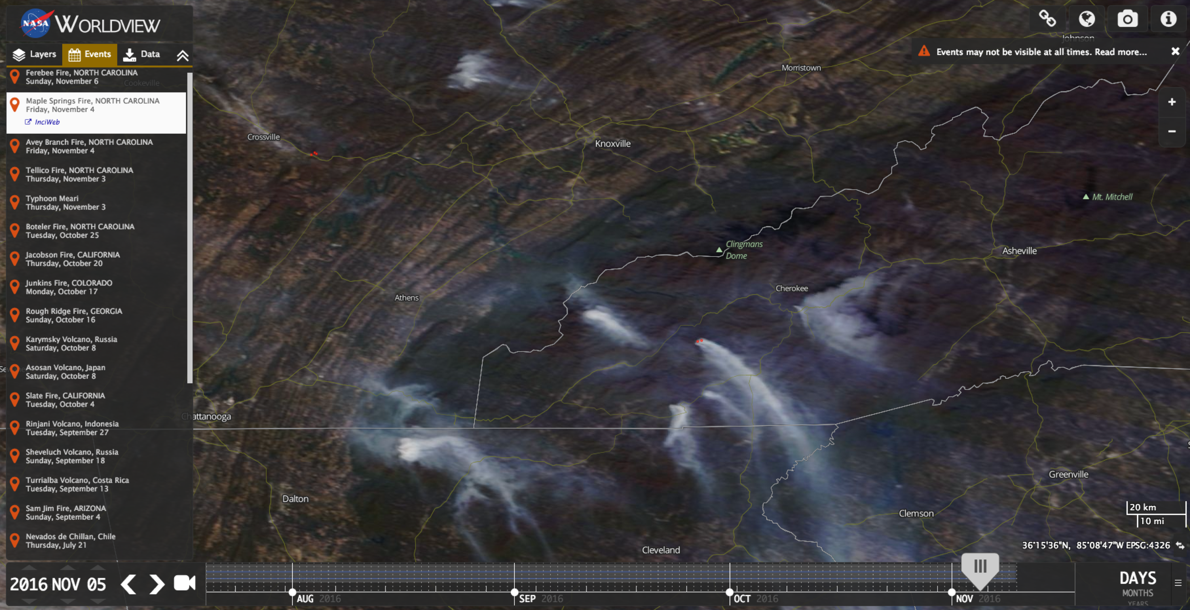
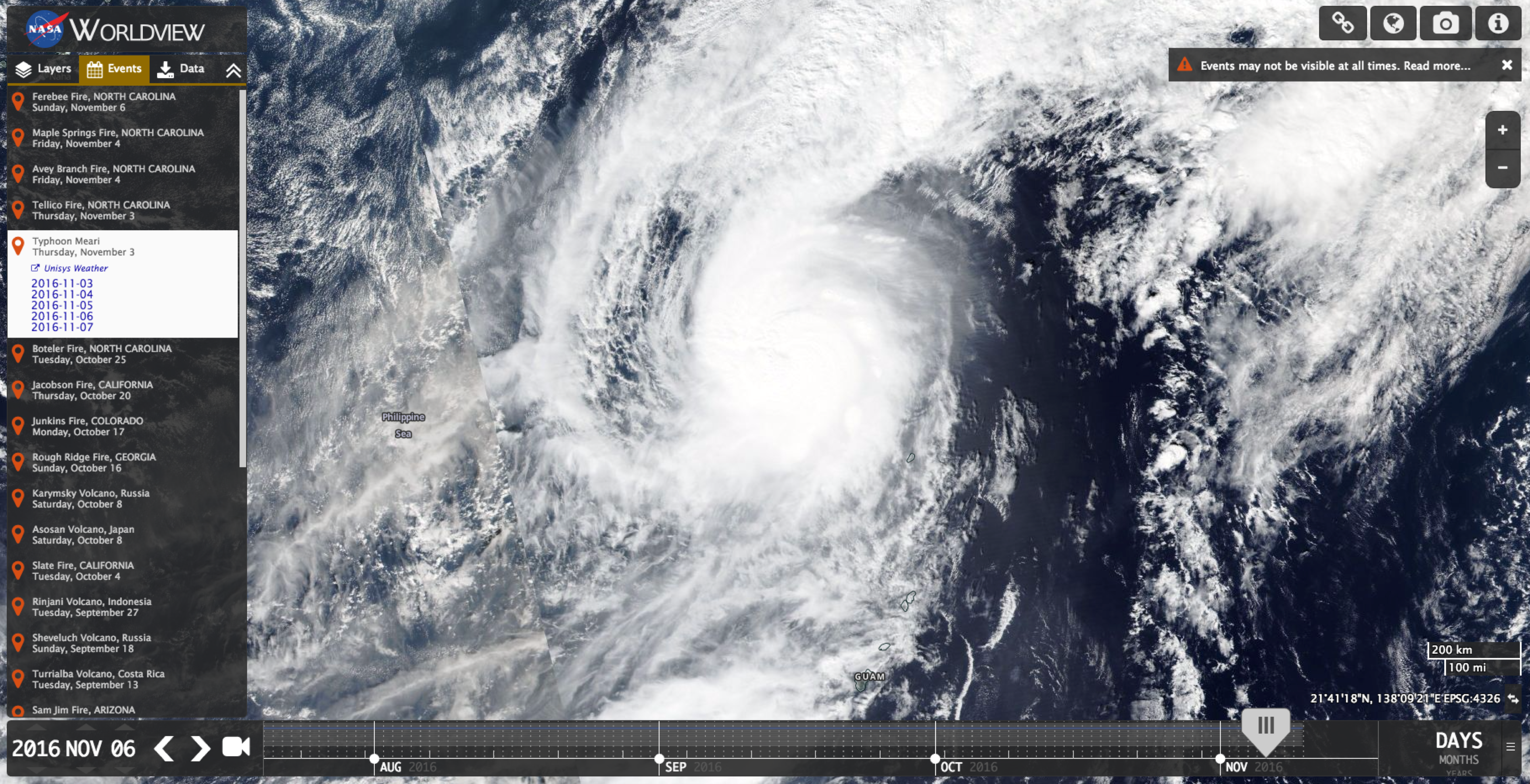
Natural Events Tab
This feature was added in collaboration with NASA Earth Observatory’s Natural Event Tracker (EONET). EONET provides a curated list of current natural events and hazards such as wildfires, severe storms and volcanic eruptions. Worldview uses this event list to provide users the ability to easily view pertinent GIBS imagery layers for the date(s) and geographical area of a selected event.
Animation
The new animation feature allows users to create, download, and share animations that more easily demonstrate the dynamic processes shown in the imagery.
Push the play button at the bottom/center of the screen here to watch the Yosemite Rim Fire grow in size and change the underlying landscape:
Here’s an example showing the calving of iceberg B-31 from Antarctica’s Pine Island Glacier:

Polar Rotation
Users are now able to rotate the imagery in the Arctic and Antarctic views. The user now has the power to decide what direction is "up".
Coming soon...
Keep your eyes peeled for new features and improvements in Worldview!