Blog from December, 2015
search
attachments
weblink
advanced
Overview
Content Tools

We are pleased to announce the availability of two new sea surface temperature layers provided by the Group for High Resolution Sea Surface Temperature (GHRSST):
- Multi-scale Ultra-high Resolution (MUR) Sea Surface Temperature (SST) available on a daily basis from June 1, 2002 through the present
- Global 1-km Sea Surface Temperature (G1SST) available on a daily basis from June 9, 2010 through the present

While we love everything that MODIS has done and is still doing after 15+ years (!), we're very excited about the next generation of moderate resolution imagery provided by VIIRS - the Visible Infrared Imaging Radiometer Suite - on the Suomi-NPP satellite! GIBS is now providing daily, global mosaics of VIIRS imagery in full resolution. These include
- Corrected Reflectance (True Color)
- Corrected Reflectance (Bands M3-I3-M11)
- Corrected Reflectance (Bands M11-I2-I1)
- Fires and Thermal Anomalies (Day, 375m)
- Fires and Thermal Anomalies (Night, 375m)
Check them out in Worldview! For this initial release, imagery begins on November 24, 2015 and is being produced in an ongoing basis in near real time - the imagery is available within 3-5 hours of acquisition from the satellite with the goal of reducing that latency further.
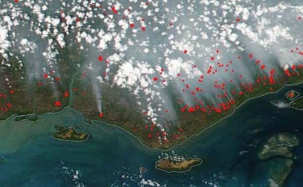
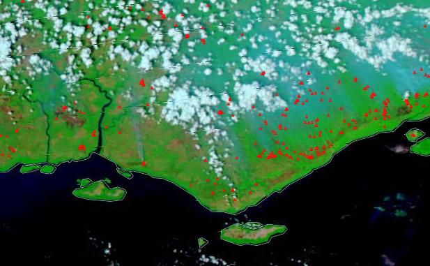
VIIRS fires are represented as tiny triangles whereas tiny dots are used for MODIS fires. The first image above shows VIIRS fires + corrected reflectance with true color bands; the second, VIIRS fires + corrected reflectance with M11-I2-I1 bands to show burned areas (reddish brown) and through the smoke.

One of the most visually striking differences between VIIRS and MODIS is that VIIRS has a wider swath which provides full coverage of the globe on a daily basis. Here is a toggle between Aqua/MODIS and Suomi-NPP/VIIRS from December 7, 2015. That wider swath does have a tradeoff, though - the maximum spatial resolution of VIIRS is 375 meters per pixel while MODIS is 250 meters per pixel.


Corrected Reflectance layers are also available in north and south polar stereographic projections. Don't mind the giant area of darkness at the north pole during this time of year! Due to the lack of winter sunlight during satellite overpasses, daytime imagery cannot be collected near the pole.
All layers are now available in Worldview, your GDAL-based scripts, your map clients, etc. We hope you enjoy them as much as we do! Feel free to contact us at support@earthdata.nasa.gov with questions or comments.

We’re pleased to announce the release of OnEarth-Boxes (https://github.com/nasa-gibs/onearth-boxes), a new system that makes it easy to create new virtual machines with pre-configured OnEarth servers for experimentation, education, and development. OnEarth is the lightweight geospatial imagery server used by GIBS to serve hundreds of products to users across multiple map projections.
Using Packer (http://packer.io) virtual machine image creation software, OnEarth-Boxes creates a ready-to-go CentOS6 VM with OnEarth, the MRF imagery storage format, and their dependencies installed and configured. Build scripts are currently included to make VMWare, VirtualBox, and Vagrant/VirtualBox images.
OnEarth-Boxes also includes some demo imagery, accessible through a simple OpenLayers endpoint. WMTS, TWMS/KML, and Mapserver endpoints are pre-configured. Use OnEarth-Boxes to get a feel for how the software works and what its capabilities are without having to integrate it within an existing system.
Since all the OnEarth/MRF utilities are included, OnEarth-Boxes is a great way to quickly get an instance of OnEarth running in order to experiment with your own imagery. Especially when using Vagrant, it’s easy to import new imagery into the VM via a shared folder, create MRFs, and add new layers to OnEarth.
OnEarth-Boxes is also useful as a sandbox for development with OnEarth or MRF. All the source code is included and linked to the Github repo by default, and all the necessary development utilities for compilation and RPM-building are installed.
The Packer build process is highly customizable and allows for easy, repeatable creation of OnEarth VMs by modifying the build parameters and scripts. The Packer infrastructure includes multiple builders and post-processors for a wide variety of VM environments.
To get started with OnEarth-Boxes, visit https://github.com/nasa-gibs/onearth-boxes.

We're pleased to announce the availability of new Global Digital Elevation Models in GIBS from Terra's Advanced Spaceborne Thermal Emission and Reflection Radiometer (ASTER) instrument and the Shuttle Radar Topography Mission (SRTM). These products are available globally at their full resolution of 30 meters per pixel.
The ASTER products were created from approximately 1.5 million scenes (ASTER stereo pair observations) dating back to 2000 and covers land surfaces between 83°N and 83°S. The SRTM product is based on Space Shuttle Endeavour's STS-99 mission in February 2000 using two radar antennas.
Shown above is the ASTER GDEM Color Shaded Relief layer. It shows surface elevation as shaded relief in color. Features such as mountains, valleys, plateaus and canyons with steep slopes will appear more rough, while flat areas will appear more smooth. Areas of lower elevation appear darker green, and areas of higher elevation are reds to white. Areas below sea level are a flat grey.

The ASTER GDEM Greyscale Shaded Relief layer (above) shows surface elevation as shaded relief in shades of grey.

The SRTM Color Index (above) and ASTER GDEM Color Index layers show land elevation around the world, measured in meters. On the default palette, white indicates the highest elevations, then brown, yellow and greens indicate low elevations.
We hope that you'll find good ways to use these with or without your other favorite NASA science data products.