Overview
ISO 19115-2, "Geographic information -- Metadata -- Part 2: Extensions for imagery and gridded data" is an extension for ISO 19115 and includes information on data properties, geospatial characteristics, processing and acquisition methods. It is anticipated that features of 19115-2 and 19115-1 may merge at some point in the future.
The ISO 19115-2:2009 standard extends the existing geographic metadata standard by defining the schema required for describing imagery and gridded data. It provides information about the properties of the measuring equipment used to acquire the data, the geometry of the measuring process employed by the equipment, and the production process used to digitize the raw data. This extension deals with metadata needed to describe the derivation of geographic information from raw data, including the properties of the measuring system, and the numerical methods and computational procedures used in the derivation. The metadata required to address coverage data in general is addressed sufficiently in the general part of ISO 19115.
Resource Fact Sheet: http://www.isotc211.org/Outreach/Overview/Factsheet_19115-2.pdf
Evolution from ISO 19115
ISO 19115-2 extends ISO 19115 specifically for imagery and gridded data. These extensions also allow for the documentation of data collected via instrumentation. The root of ISO 19115 metadata records will change from MD_Metadata to MI_Metadata when using ISO 19115-2. A new section is also added, gmi:acquisitionInformation includes the new packagage, MI_AcquisitionInformation.
Figure 1: and the relationship to MD_Metadata.
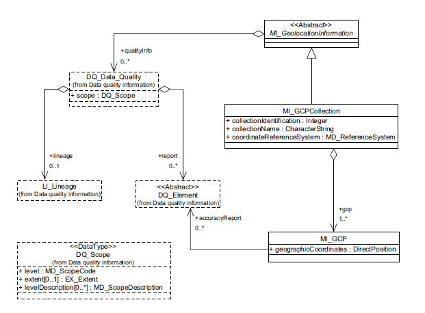
MI_Acquisition includes several other new packages. MI_Operation provides information of the overall data gathering program. MI_Platform provides information about the platform from which the data were taken. MI_Instrument provides designation of the measuring instruments used to acquire the data. MI_Objective describes the characteristics and geometry of the intended object to be observed. MI_Requirement details the requirements used to derive the acquisition plan. MI_Plan details the implementation. MI_Event describes a significant even that occurred. MI_PlatformPass identifies a particular pass made by the platform during data acquisition. The spatial representation package is extended in ISO 19115-2. MD_Georectified is extended to include check point information to further specify georectification details, from MI_GCP, in MI_Georectified. MD_Georeferenceable is extended to include additional information that can be used to geolocate the data, from MI_GeolocationInformation, in MI_Georeferenceable.
Content information is extended to describe the content of a coverage. MD_Band is extended to define additional attributes for specifying properties of individual wavelength bands in MI_Band. MI_RangeElementDescription was added to provide indentification of the range of elements used in a coverage dataset. MD_ImageDescription is extended to include MI_RangeElementDescription in MI_Image Description. MD_CoverageDescription is also extended to include MI_RangeElementDescription in MI_CoverageDescription.
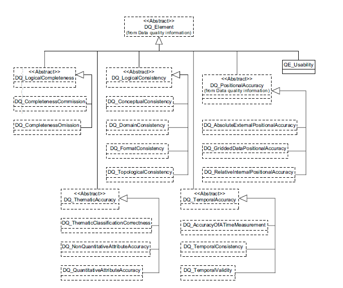
Data Quality was also extended in ISO 19115-2. LI_Source was extended to describe the output of a process step in LE_Source. LE_ProcessStepReport was added to identify external information about the processing steps. LE_Algorithm is added to describe the methodology used to derive the data from the source data. LE_Processing includes LE_Algorithm and adds information to describe the procedure by which the algorithm is applied to generate the product. LI_ProcessStep is extended to describe additional information on the history of algorithms used and the processing performed to produce the data in LE_ProcessStep. QE_Usability is added to provided specific quality information about a dataset’s suitability for a particular application. DQ_Result is extended to include information required to report data quality for a coverage in QE_CoverageResult. MD_SpatialRepresentation, MD_CoverageDescription, and MD_Format are added to data quality in order to describe the coverage result. MX_DataFile is added to identify a complete report of the quality of the coverage.
Modifications to Data Quality
QE_CoverageResult
QE_CoverageResult provides a means to document the quality associated with coverages (as defined by MD_Format).
LE_Lineage
LE_Lineage adds additional lineage/quality information relating to:
- Processing and process steps
- Algorithms
- Source(s)
- Geospatial relationships between pixels (nominal resolution)
QE_Usability
QE_Usability provides a means to documents the utility of a data entity relative to a user's requirements.
Data Quality extended with QE_Usability
Spatial Extensions to ISO 19115-2
Extension to georectified and georeferenceable classes
MI_Georectified (includes information to allow for the geolocational validation of gridded data), MI_Georeferenceable (extends the 19115 class to include information that can be used to geolocate raster imagery) and the associated classes comprise extensions required to specify the spatial representation for imagery and gridded data.
Ground Control Point Quality
Provides information relevant to the quality of GCPs.
Content Information
19115-2 provides extensions to allow for description of the content of imagery and gridded data datasets
Acquisition Information
Acquisition Overview
Acquisition Overview pertains to the metadata classes required to define the acquisition of imagery and gridded datasets.
Acquisition Details
Acquisition Details contains means to document the specific acquisition of imagery and gridded datasets.


