Page History
| Excerpt | ||
|---|---|---|
| ||
I need to provide information about the spatial representation of the resource and the parameters being measured or calculated. |
I need to provide information about the content of the resource and the parameters being measured or calculated.
Overview
The ISO Coverage Content Information package provides fields for describing the content of imagery and gridded data datasets.
Recommendations
Documentation Objectives
- Describe multi-dimesional gridded datasets in the metadata.
Conceptual Model
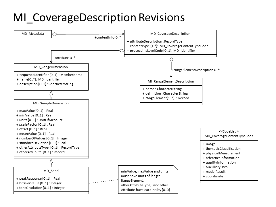
The MI_CoverageDescriptions Figure shows the simplified UML of the three objects available for describing multi-layered datasets. How are these objects used?
MI_CoverageDescription/attributeDescription The attributeDescription provides a description of the attributes in the dataset and potentially the format. It is typically implemented as an xlink to an external resource which is, hopefully, machine readable. It might be some time before this goal is reached. In the mean time, this could be a human readable resoiurce. For example, the SST dataset could include a link to the NESDIS Polar Data Users Guide like
<gmd:attributeDescription
xlink:href="http://www.ncdc.noaa.gov/oa/pod-guide/ncdc/docs/klm/html/c9/sec91-1.htm"/>
MI_CoverageDescription/MD_CoverageContentTypeCode is a codeList that gives the type of the coverage. The Standard includes three options: image, thematicClassification, and physicalMeasurement. It seems likely that we will need to add some other values to this content to describe the variety of types included in satellite products. Additions suggested for the revision of the Standard include: referenceInformation, qualityInformation, auxilliaryData, and modelResult.
MI_CoverageDescription/dimension An MD_CoverageDescription can contain any number of dimensions. This role name seems to cause quite a bit of confusion. The object that it refers to is a MD_RangeDimension or a MD_Band, and the elements in the MD_Band object (minValue, maxValue, units, scaleFactor, and offet) suggest that this could be one of the layers in a multi-dimensional dataset. The definitions of these elements, however, clearly indicate that this is, in fact, a band in the electromagnetic spectrum. Changes to this structure have been proposed as part of the revision to 19115. That proposal is described below.
MD_RangeDimension/sequenceIdentifier/MemberName This field uniquely identifies the band and relates it to the attributeDescription. It includes a name that does not get translated into other languages, and a type.
MD_RangeDimension/sequenceIdentifier/descriptor This field provides a short description of the band.
MD_Band Definitions
Element/Role NameCurrent Definition MD_Band Band range of wavelengths in the electromagnetic spectrum maxValue longest wavelength that the sensor is capable of collecting within a designated band minValue shortest wavelength that the sensor is capable of collecting within a designated band units units in which sensor wavelengths are expressed scaleFactor scale factor which has been applied to the cell value offset offset the physical value corresponding to a cell value of zero
Implementation (XML)
<gmd:contentInfo>
  <gmd:MD_CoverageDescription>
    <gmd:attributeDescription gco:nilReason="inapplicable"/>
    <gmd:contentType>
      <gmd:MD_CoverageContentTypeCode codeList="" codeListValue="referenceInformation">referenceInformation</gmd:MD_CoverageContentTypeCode>
    </gmd:contentType>
    <gmd:attribute>
      <gmd:MD_SampleDimension>
        <gmd:sequenceIdentifier>
          <gco:MemberName>
            <gco:aName>
              <gco:CharacterString>lat</gco:CharacterString>
            </gco:aName>
            <gco:attributeType>
              <gco:TypeName>
                <gco:aName>
                  <gco:CharacterString>gco:Real</gco:CharacterString>
                </gco:aName>
              </gco:TypeName>
            </gco:attributeType>
          </gco:MemberName>
        </gmd:sequenceIdentifier>
        <gmd:descriptor>
          <gco:CharacterString>Latitude Coordinate Variable</gco:CharacterString>
        </gmd:descriptor>
        <gmd:name>
          <gmd:MD_Identifier>
            <gmd:code>
              <gco:CharacterString>latitude</gco:CharacterString>
            </gmd:code>
            <gmd:codeSpace>
              <gco:CharacterString>http://cf-pcmdi.llnl.gov/documents/cf-standard-names/</gco:CharacterString>
            </gmd:codeSpace>
          </gmd:MD_Identifier>
        </gmd:name>
        <gmd:maxValue>
          <gco:Real>90.0</gco:Real>
        </gmd:maxValue>
        <gmd:minValue>
          <gco:Real>-90.0</gco:Real>
        </gmd:minValue>
        <gmd:units xlink:href="http://someUnitsDictionary#degrees_north"/>
      </gmd:MD_SampleDimension>
    </gmd:attribute>
    <gmd:attribute>
      <gmd:MD_SampleDimension>
        <gmd:sequenceIdentifier>
          <gco:MemberName>
            <gco:aName>
              <gco:CharacterString>lon</gco:CharacterString>
            </gco:aName>
            <gco:attributeType>
              <gco:TypeName>
                <gco:aName>
                  <gco:CharacterString>gco:Real</gco:CharacterString>
                </gco:aName>
              </gco:TypeName>
            </gco:attributeType>
          </gco:MemberName>
        </gmd:sequenceIdentifier>
        <gmd:descriptor>
          <gco:CharacterString>Longitude Coordinate Variable</gco:CharacterString>
        </gmd:descriptor>
        <gmd:name>
          <gmd:MD_Identifier>
            <gmd:code>
              <gco:CharacterString>longitude</gco:CharacterString>
            </gmd:code>
            <gmd:codeSpace>
              <gco:CharacterString>http://cf-pcmdi.llnl.gov/documents/cf-standard-names/</gco:CharacterString>
            </gmd:codeSpace>
          </gmd:MD_Identifier>
        </gmd:name>
        <gmd:maxValue>
          <gco:Real>180</gco:Real>
        </gmd:maxValue>
        <gmd:minValue>
          <gco:Real>-180</gco:Real>
        </gmd:minValue>
        <gmd:units xlink:href="http://someUnitsDictionary#degrees_east"/>
      </gmd:MD_SampleDimension>
    </gmd:attribute>
  </gmd:MD_CoverageDescription>
</gmd:contentInfo>
<gmd:contentInfo>
  <gmd:MD_CoverageDescription>
    <gmd:attributeDescription gco:nilReason="inapplicable"/>
    <gmd:contentType>
      <gmd:MD_CoverageContentTypeCode codeList="" codeListValue="physicalMeasurement">physicalMeasurement</gmd:MD_CoverageContentTypeCode>
    </gmd:contentType>
    <gmd:attribute>
      <gmd:MD_SampleDimension>
        <gmd:sequenceIdentifier>
          <gco:MemberName>
            <gco:aName>
              <gco:CharacterString>temp</gco:CharacterString>
            </gco:aName>
            <gco:attributeType>
              <gco:TypeName>
                <gco:aName>
                  <gco:CharacterString>gco:Real</gco:CharacterString>
                </gco:aName>
              </gco:TypeName>
            </gco:attributeType>
          </gco:MemberName>
        </gmd:sequenceIdentifier>
        <gmd:descriptor>
          <gco:CharacterString>Temperature Variable</gco:CharacterString>
        </gmd:descriptor>
        <gmd:name>
          <gmd:MD_Identifier>
            <gmd:code>
              <gco:CharacterString>air_temperature</gco:CharacterString>
            </gmd:code>
            <gmd:codeSpace>
              <gco:CharacterString>http://cf-pcmdi.llnl.gov/documents/cf-standard-names/</gco:CharacterString>
            </gmd:codeSpace>
          </gmd:MD_Identifier>
        </gmd:name>
        <gmd:maxValue>
          <gco:Real>250</gco:Real>
        </gmd:maxValue>
        <gmd:minValue>
          <gco:Real>300</gco:Real>
        </gmd:minValue>
        <gmd:units xlink:href="http://someUnitsDictionary#K"/>
      </gmd:MD_SampleDimension>
    </gmd:attribute>
  </gmd:MD_CoverageDescription>
</gmd:contentInfo>
Implementation (NcML)
Usage
Crosswalks
Notes
| Hide comments |
|---|
Overview
Content Tools