Versions Compared

Key

  • This line was added.
  • This line was removed.
  • Formatting was changed.

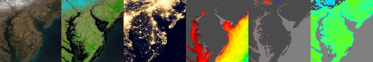
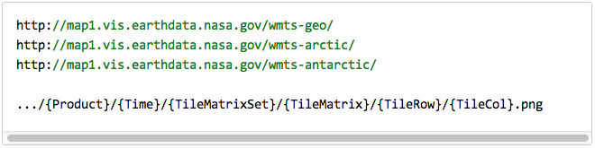
The Global Imagery Browse Services (GIBS) system is a core EOSDIS component which provides a scalable, responsive, highly available, and community standards based set of imagery services.  These services are designed with the goal of advancing  user interactions with EOSDIS’ inter-disciplinary data through enhanced visual representation and discovery.  For a full overview, visit the  GIBS landing page .  For open source code to the GIBS OnEarth server, MRF tiled imagery storage format, and mapping examples, see the  GIBS GitHub page .  For detailed information about available imagery products and accessing GIBS, see below.


Anchor
user-info
user-info
Information for Users:

UI Button
colorgreen
sizesmall
displayblock
icontext
titleImagery Products
urlhttps://wiki.earthdata.nasa.gov/display/GIBS/GIBS+Available+Imagery+Products

UI Button
colorgreen
sizesmall
displayblock
icontext
titleGIBS API for Developers
urlhttps://wiki.earthdata.nasa.gov/display/GIBS/GIBS+API+for+Developers


UI Button
colorgreen
sizesmall
displayblock
icontext
titleMap Library Usage
urlhttps://wiki.earthdata.nasa.gov/display/GIBS/Map+Library+Usage

UI Button
colorgreen
sizesmall
displayblock
icontext
titleGIS Tool Usage
urlhttps://wiki.earthdata.nasa.gov/display/GIBS/Geographic+Information+System+%28GIS%29+Usage

Anchor
collaborator-info
collaborator-info
Information for Collaborators:

Anchor
collaborator-info
collaborator-info
Information for Everyone