Page History
Global Imagery Browse Services
Introduction
The Global Imagery Browse Services (GIBS)
100+ full resolution, global imagery products from NASA Earth Observing System satellites are available in near real-time (usually within 3.5 hours of observation) courtesy of LANCE data providers and other sources. This includes products from the MODIS instrument aboard Terra and Aqua, the AIRS instrument aboard Aqua, and the OMI instrument aboard Aura.
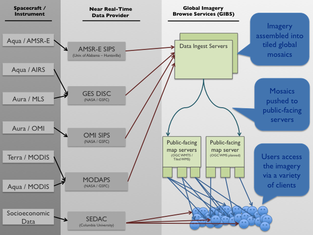
Architecture
GIBS is composed of
- servers which ingest and convert imagery from NASA data providers into full-resolution, mosaicked layers; these layers are then chopped into imagery tiles stored at predefined zoom levels
- servers which serve the tiles created above to any internet-enabled client
By pregenerating these tiles, it relieves the server of image rescaling and cropping duties, greatly reducing the computational overhead and enabling a highly responsive and scalable system. This also means that the primary method of imagery retrieval for clients is tile-based.
Access
The Open Geospatial Consortium (OGC) Web Map Tile Service (WMTS) is one recommended method of access to GIBS imagery. An alternate is Tiled Web Map Service (TWMS), an extension to the OGC Web Map Service (WMS) where only requests that match the exact geographic tile boundaries will be honored. Finally, Google Earth KML files can be dynamically generated for GIBS products. The implementation of these services is built from the long-running "OnEarth" server system at NASA/JPL.
Detailed Information
- Access Methods (OGC WMTS, Tiled WMS, Google Earth KML)
- Supported Clients (OpenLayers, Google Earth, NASA World Wind, etc)
- Available Imagery Products (Terra/MODIS Corrected Reflectance, Aqua/AIRS Dust Score, etc)
Data Use Policy
NASA supports an open data policy. Please see here for more information.
Acknowledgement
We would ask end users who make use of GIBS in their clients or when referencing it in written or oral presentations to add the following acknowledgment:
We acknowledge the use of imagery from the Land Atmosphere Near real-time Capability for EOS (LANCE) system and services from the Global Imagery Browse Services (GIBS), both operated by the NASA/GSFC/Earth Science Data and Information System (ESDIS, http://earthdata.nasa.gov) with funding provided by NASA/HQ.
Contact
Please contact us with questions or problems at Earthdata support
To stay up to date with new capabilities or changes to existing services, you may want to subscribe to our mailing list.
GIBS Development and Operations
system is a core EOSDIS component which provides a scalable, responsive, highly available, and community standards based set of imagery services. These services are designed with the goal of advancing user interactions with EOSDIS’ inter-disciplinary data through enhanced visual representation and discovery. For a full overview including the GIBS open data policy and contact information, visit the GIBS home page. For open source code to the GIBS OnEarth server, MRF tiled imagery storage format, and mapping examples, see the GIBS GitHub page. For detailed information about available imagery products and accessing GIBS, see below.
| Anchor | ||||
|---|---|---|---|---|
|
| UI Button | ||||||||||||
|---|---|---|---|---|---|---|---|---|---|---|---|---|
|
| UI Button | ||||||||||||
|---|---|---|---|---|---|---|---|---|---|---|---|---|
|
| Anchor | ||||
|---|---|---|---|---|
|
Navigate space
| Page Tree Search |
|---|
| Page Tree |
|---|
hide-child-pages
Overview
Content Tools