...
The GIBS team is actively engaging the NASA EOSDIS data centers to add more imagery products and to extend their coverage throughout the life of the mission. The remainder of this page provides a structured view of the layers currently available within GIBS grouped by science discipline and science observation. For information regarding how to access these products through the GIBS API, refer to the Access Methods section of this wiki. For information regarding how to access these products through an existing GIS/mapping client, refer to the Supported Clients section of this wiki. If you are aware of a science parameter that you would like to see visualized, please contact us at support@earthdata.nasa.gov.
 Image RemovedImage RemovedImage Removed
 Image Added
 Image Added
 Image Added
| Note |
|---|
As noted above, imagery products within GIBS are generated based on near real-time and standard science products. To understand the difference between these two data products, review the following page: MODIS Near Real-Time vs Science Quality. |
...
Science parameter visualizations are generated by mapping scientific measurements into an RGB image. Each measured value, or range of values, is assigned a unique color to create a visual representation of the underlying data values. This may also apply to classification data. Choose one of the following science disciplines, or scroll down, to view the imagery products available within GIBS.
Atmosphere
...
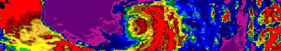 Image Added
| UI Expand |
|---|
| title | Aerosol Optical Depth (6 Products) |
|---|
|
| Platform | Instrument | Imagery Layer | Resolution [3] | Format | Projection(s)[4] | Temporal Range | Data Product | SDS |
|---|
| Aura | OMI | Aerosol Index OMI_Aerosol_Index | 2km | png | Geographic | 2012-05-08 -> Present (NRT) | OMAERUV | | | Terra | MODIS | Aerosol Optical Depth MODIS_Terra_Aerosol | 2km | png | Geographic | 2012-05-08 -> Present (NRT) | MOD04_L2 v5 | | | Aqua | MODIS | Aerosol Optical Depth MODIS_Aqua_Aerosol | 2km | png | Geographic | 2012-05-08 -> Present (NRT) | MYD04_L2 v5 | | | Terra/Aqua | MODIS | MODIS Combined Value-Added Aerosol Optical Depth MODIS_Combined_Value_Added_AOD | 2km | png | Geographic | 2013-01-31 -> Present (NRT) | | | | Aura | OMI | Aerosol Optical Depth OMI_Aerosol_Optical_Depth | 2km | png | Geographic | 2012-05-08 -> Present (NRT) | OMAERUV | | | Aura | OMI | Absorbing Aerosol Optical Depth OMI_Absorbing_Aerosol_Optical_Depth | 2km | png | Geographic | 2012-05-08 -> Present (NRT) | OMAERUV | |
|
...
| UI Expand |
|---|
| title | Water Vapor (6 Products) |
|---|
|
| Platform | Instrument | Imagery Layer | Resolution [3] | Format | Projection(s)[4] | Temporal Range | Data Product | SDS |
|---|
| Terra | MODIS | Water Vapor (day) MODIS_Terra_Water_Vapor_5km_Day | 2km | png | Geographic | 2012-05-08 -> Present (NRT) | | | | Terra | MODIS | Water Vapor (night) MODIS_Terra_Water_Vapor_5km_Night | 2km | png | Geographic | 2012-05-08 -> Present (NRT) | | | | Aqua | MODIS | Water Vapor (day) MODIS_Aqua_Water_Vapor_5km_Day | 2km | png | Geographic | 2012-05-08 -> Present (NRT) | | | | Aqua | MODIS | Water Vapor (night) MODIS_Aqua_Water_Vapor_5km_Night | 2km | png | Geographic | 2012-05-08 -> Present (NRT) | | | | Aura | MLS | Water Vapor (H2O) at 46 hPa (Day) MLS_H2O_46hPa_Day | 2km | png | Geographic | 2013-05-09 -> Present (NRT) | ML2H20_NRT v003 | | | Aura | MLS | Water Vapor (H2O) at 46 hPa (Night) MLS_H2O_46hPa_Night | 2km | png | Geographic | 2013-05-09 -> Present (NRT) | ML2H20_NRT v003 | |
|
Cryosphere
Image Removed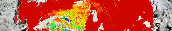 Image Added
| UI Expand |
|---|
| title | Sea Ice (2 Products) |
|---|
|
| Platform | Instrument | Imagery Layer | Resolution [3] | Format | Projection(s)[4] | Temporal Range | Data Product |
|---|
| Terra | MODIS | Sea Ice MODIS_Terra_Sea_Ice | 1km | png | Geographic, Polar | 2012-05-08 -> Present (NRT) | MOD29 v5 | | Aqua | MODIS | Sea Ice MODIS_Aqua_Sea_Ice | 1km | png | Geographic, Polar | 2012-05-08 -> Present (NRT) | MYD29 v5 |
|
| UI Expand |
|---|
| title | Snow Cover (2 Products) |
|---|
|
| Platform | Instrument | Imagery Layer | Resolution [3] | Format | Projection(s)[4] | Temporal Range | Data Product |
|---|
| Terra | MODIS | Snow Cover MODIS_Terra_Snow_Cover | 500m | png | Geographic, Polar | 2012-05-08 -> Present (NRT) | MOD10_L2 v5 | | Aqua | MODIS | Snow Cover MODIS_Aqua_Snow_Cover | 500m | png | Geographic, Polar | 2012-05-08 -> Present (NRT) | MYD10_L2 v5 |
|
Land
...
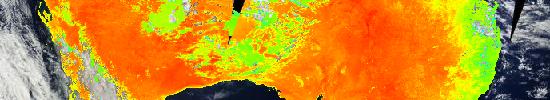 Image Added
| UI Expand |
|---|
| title | Land Surface Temperature (4 Products) |
|---|
|
| Platform | Instrument | Imagery Layer | Resolution [3] | Format | Projection(s)[4] | Temporal Range | Data Product |
|---|
| Terra | MODIS | Land Surface Temperature (day) MODIS_Terra_Land_Surface_Temp_Day | 1km | png | Geographic | 2012-05-08 -> Present (NRT) | MOD11_L2 v5 | | Terra | MODIS | Land Surface Temperature (night) MODIS_Terra_Land_Surface_Temp_Night | 1km | png | Geographic | 2012-05-08 -> Present (NRT) | MOD11_L2 v5 | | Aqua | MODIS | Land Surface Temperature (day) MODIS_Aqua_Land_Surface_Temp_Day | 1km | png | Geographic | 2012-05-08 -> Present (NRT) | MYD11_L2 v5 | | Aqua | MODIS | Land Surface Temperature (night) MODIS_Aqua_Land_Surface_Temp_Night | 1km | png | Geographic | 2012-05-08 -> Present (NRT) | MOD11_L2 v5 |
|
Ocean
Image Removed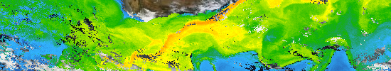 Image Added
| UI Expand |
|---|
| title | Chlorophyll (2 Products) |
|---|
|
| Platform | Instrument | Imagery Layer | Resolution [3] | Format | Projection(s)[4] | Temporal Range | Data Product |
|---|
| Terra | MODIS | MODIS_Terra_Chlorophyll_A | 1km | png | Geographic | 2013-07-02 -> Present | | | Aqua | MODIS | MODIS_Aqua_Chlorophyll_A | 1km | png | Geographic | 2013-07-02 -> Present | |
|
...