|
| Attendees | Item | Notes |
|---|
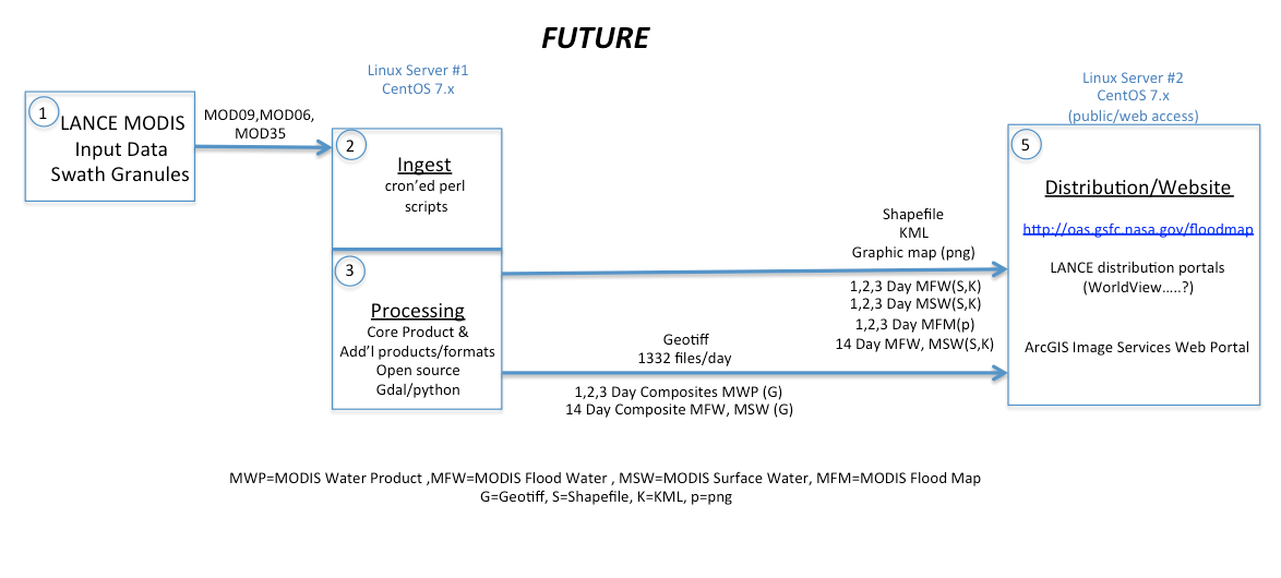
Diane Davies Gang Ye Edward Masuoka @Frederick Pollicelli @Dan Slayback | Phase 1: Granule Module | - Flood product is currently run using IDL and ENVI and it uses 10 x 10 degree tiles (MOD09, MOD35 and MOD06) as input and generates MODIS Water Detection (MWD) and MODIS Cloud and Shadow (MCS) data files in same format.
- Dan will modify code to use granule data as input so the MWD and MCS can be processed as soon as the data are available
- Dan will assess whether the to use IDL / ENVI or GDAL / Geo Tools
- no licenses are required for the GDAL option but if it is going to take longer, Ed is willing to buy another ENVI license
- Dan to provide feedback the week of 10th July
- Dan will then deliver his code to Gang (by 17 July)
- Gang and LAADs team will take the code and wrap it in to PGEs for NRT processing
|
Phase 2: Mapping and Compositing module This module creates products on a global 250m grid | - Who: PI staff can prototype, but TBD who will build and operate this component (LANCE or PI staff). Schedule: Start after stage 1 complete.
Estimated completion: TBD |
| Phase 3: Post processing module for distribution | - Generate final distribution format files (geotiff, shapefile, KMZ, graphics) from the master product and publish to web, ftp, GIBS (if possible), etc.
- Diane to review information Fritz collected from user survey and to develop additional questions (as appropriate) and contact users to develop end user requirements.
|