- The inclusions library is not a specific feature of Confluence. The pages in the inclusions library are just like any other Confluence page.
- The pages are located at the root of the wiki space, not under the homepage. This means that they will not appear in the table of contents on the left and they will not be picked up by the search in the left-hand navigation bar either.
- The pages will be picked up by other global searches, because they are just normal wiki pages.
- We have decided to start the page name with an underscore. For example, '_InclusionLibrary'. This indicates that the page is slightly unusual, and will help prevent people from changing the page name or updating the content without realising that the content is re-used in various pages.
- ISO 19115
- Metadata information (MD_Metadata)
- Identification information (MD_Identification)
- Constraint information (MD_Constraints)
- Data Quality (DQ_DataQuality)
- Lineage information (LI_Lineage)
- Maintenance information (MD_MaintenanceInformation)
- Spatial representation information (MD_SpatialRepresentation)
- Reference system information (MD_ReferenceSystem)
- Content information (MD_ContentInformation)
- Portrayal catalogue information (MD_PortrayalCatalogueReference)
- Distribution information (MD_Distribution)
- Metadata extension information (MD_MetadataExtensionInformation)
- Application schema information (MD_ApplicationSchemaInformation)
- Service metadata information
- Extent information (EX_Extent)
- Citation and responsible party information (CI_Citation and CI_ResponsibleParty) classes
ISO 19115
Technical Committee 211 of the International Standards Organization (ISO) has defined a series of standards for geographic metadata and services. Many of these standards are closely related to and compatible with OGC Standards. These standards are currently being adopted across the NASA Earth Science community and by many partners in the U.S. and around the world.
ISO 19115 is the primary metadata standard in the ISO TC211 Collection. The objective of ISO 19115 is to provide a structure for describing digital geographic data. It defines metadata elements, provides a schema (ISO 19139) and establishes a common set of metadata terminology, definitions, and extension procedures. It provides information about the identification, the extent, the quality, the spatial and temporal schema, spatial reference, and distribution of digital geographic data.
ISO 19115 defines:
- mandatory and conditional metadata sections, metadata entities, and metadata elements;
- the minimum set of metadata required to serve the full range of metadata applications (data discovery, determining data fitness for use, data access, data transfer, and use of digital data);
- optional metadata elements – to allow for a more extensive standard description of geographic data, if required;
- a method for extending metadata to fit specialized needs.
Metadata information (MD_Metadata)
The MD_Metadata package defines the schema for describing the complete metadata about a resource (DS_Resource) and metadata about the metadata itself.
Identification information (MD_Identification)
Identification information supports the provision of information to uniquely identify a resource. MD_Identification can be specified as MD_DataIdentification or SV_ServiceIdentification and is an aggregate of eight classes of metadata which aid in resource identification.
Constraint information (MD_Constraints)
This package supports the provision of metadata concerning the legal and security constraints placed on resources. It consists of MD_Constraints which can be specified as MD_LegalConstraints and/or MD_SecurityConstraints.
Data Quality (DQ_DataQuality)
For more detailed information, see the page on ISO 19157.

Lineage information (LI_Lineage)
This package supports the provision of metadata concerning the sources and production processes used in producing a resource. The DQ_DataQuality class is defined in ISO 19157. LI_Lineage is defined in 19157 while LE_Lineage is defined in 19115-2.
Maintenance information (MD_MaintenanceInformation)
This package supports the provision of metadata related to the scope and frequency of maintenance for a resource.
Spatial representation information (MD_SpatialRepresentation)
This package supports the provision of metadata identifying the spatial primitives used by a resource; the mechanisms used to model real world phenomena in a digital information system. It consists of the MD_SpatialRepresentation which can be specified as either MD_VectorSpatialRepresentation or MD_GridSpatialRepresentation which can be further specified as MD_Georectified or MD_Georeferencable.
Reference system information (MD_ReferenceSystem)
This package supports the metadata identifying the spatial and temporal reference system(s) used by a resource.
Content information (MD_ContentInformation)
This package supports the provision of metadata identifying the content of a resource by: citing the feature catalog used to define the content (MD_FeatureCatalogueDescription); incorporating the feature catalogue (MD_FeatureCatalogue – defined in ISO 19110); or describing the content of a coverage resource (MD_CoverageDescription) which also may be specified as MD_ImageDescription.
Portrayal catalogue information (MD_PortrayalCatalogueReference)
The portrayal catalogue describes how the resource can be rendered for human visualisation.
Distribution information (MD_Distribution)
This package supports the provision of metadata about the distributor of, and options for obtaining, a resource.
Metadata extension information (MD_MetadataExtensionInformation)
This package supports the provision of information about user specified metadata extensions.
Application schema information (MD_ApplicationSchemaInformation)
This package supports the provision of metadata describing the application schema used to define and expose the structure of a resource.
Service metadata information
The a combination of documentation packages used to describe metadata or data services. The structure of service metadata includes three major classes: a section of basic service metadata (SV_ServiceIdentification class) that provides a general description of the service and two sections that describe the operations (SV_OperationMetadata) and data (MD_DataIdentification) available from a particular service.
Extent information (EX_Extent)
The datatype in this package is an aggregate of the metadata elements that describe the spatial and temporal extent of resources, objects, events, or phenomena. The EX_Extent class contains information about the geographic (EX_GeographicExtent), temporal (EX_TemporalExtent) and the vertical (EX_VerticalExtent) extent of something.
Citation and responsible party information (CI_Citation and CI_ResponsibleParty) classes
This package provides a standardized method for citing a resource, as well as information about the party responsible for a resource. Citations use CI_Citation and cite the party responsible by aggregating CI_ResponsiblePartyInfo.
and Another Page
Overview
ISO 19115-2, "Geographic information -- Metadata -- Part 2: Extensions for imagery and gridded data" is an extension for ISO 19115 and includes information on data properties, geospatial characteristics, processing and acquisition methods. It is anticipated that features of 19115-2 and 19115-1 may merge at some point in the future.
The ISO 19115-2:2009 standard extends the existing geographic metadata standard by defining the schema required for describing imagery and gridded data. It provides information about the properties of the measuring equipment used to acquire the data, the geometry of the measuring process employed by the equipment, and the production process used to digitize the raw data. This extension deals with metadata needed to describe the derivation of geographic information from raw data, including the properties of the measuring system, and the numerical methods and computational procedures used in the derivation. The metadata required to address coverage data in general is addressed sufficiently in the general part of ISO 19115.
Resource Fact Sheet: http://www.isotc211.org/Outreach/Overview/Factsheet_19115-2.pdf
Evolution from ISO 19115
ISO 19115-2 extends ISO 19115 specifically for imagery and gridded data. These extensions also allow for the documentation of data collected via instrumentation. The root of ISO 19115 metadata records will change from MD_Metadata to MI_Metadata when using ISO 19115-2. A new section is also added, gmi:acquisitionInformation includes the new packagage, MI_AcquisitionInformation.
Figure 1: and the relationship to MD_Metadata. 
Overview of 19115-2 Extensions and Alterations
In comparison with ISO 19115, ISO 19115-2 offers multiple extensions and imagery-specific modifications. These include:
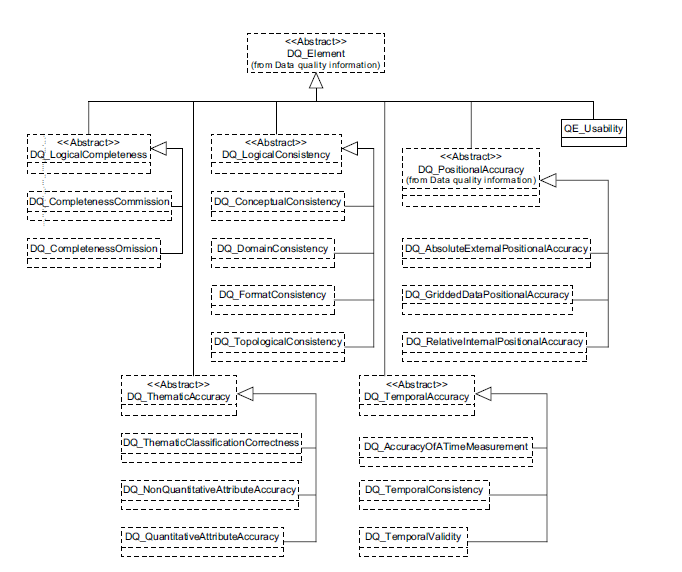
Data Quality
- LI_Source was extended to describe the output of a process step in LE_Source.
- LE_ProcessStepReport was added to identify external information about the processing steps.
- LE_Algorithm is added to describe the methodology used to derive the data from the source data.
- LE_Processing includes LE_Algorithm and adds information to describe the procedure by which the algorithm is applied to generate the product.
- LI_ProcessStep is extended to describe additional information on the history of algorithms used and the processing performed to produce the data in LE_ProcessStep.
- QE_Usability is added to provided specific quality information about a dataset’s suitability for a particular application.
- DQ_Result is extended to include information required to report data quality for a coverage in QE_CoverageResult.
- MD_SpatialRepresentation, MD_CoverageDescription, and MD_Format are added to data quality in order to describe the coverage result.
- MX_DataFile is added to identify a complete report of the quality of the coverage.
Spatial Representation
- MD_Georectified is extended to include check point information.
- MD_Georeferenceable is extended to include additional information that can be used to geolocate the data, from MI_GeolocationInformation, in MI_Georeferenceable.
Content information
- MD_Band is extended to define additional attributes for specifying properties of individual wavelength bands in MI_Band.
- MI_RangeElementDescription was added to provide indentification of the range of elements used in a coverage dataset.
- MD_ImageDescription is extended to include MI_RangeElementDescription in MI_Image Description.
- MD_CoverageDescription is also extended to include MI_RangeElementDescription in MI_CoverageDescription.
MI_Acquisition
- MI_Operation provides information of the overall data gathering program.
- MI_Platform provides information about the platform from which the data were taken.
- MI_Instrument provides designation of the measuring instruments used to acquire the data.
- MI_Objective describes the characteristics and geometry of the intended object to be observed.
- MI_Requirement details the requirements used to derive the acquisition plan.
- MI_Plan details the implementation. MI_Event describes a significant even that occurred.
- MI_PlatformPass identifies a particular pass made by the platform during data acquisition
Modifications to Data Quality
QE_CoverageResult
QE_CoverageResult provides a means to document the quality associated with coverages (as defined by MD_Format).
LE_Lineage
LE_Lineage adds additional lineage/quality information relating to:
- Processing and process steps
- Algorithms
- Source(s)
- Geospatial relationships between pixels (nominal resolution)

QE_Usability
QE_Usability provides a means to documents the utility of a data entity relative to a user's requirements.
Data Quality extended with QE_Usability
Loading
Spatial Extensions to ISO 19115-2
Extension to georectified and georeferenceable classes
MI_Georectified (includes information to allow for the geolocational validation of gridded data), MI_Georeferenceable (extends the 19115 class to include information that can be used to geolocate raster imagery) and the associated classes comprise extensions required to specify the spatial representation for imagery and gridded data.

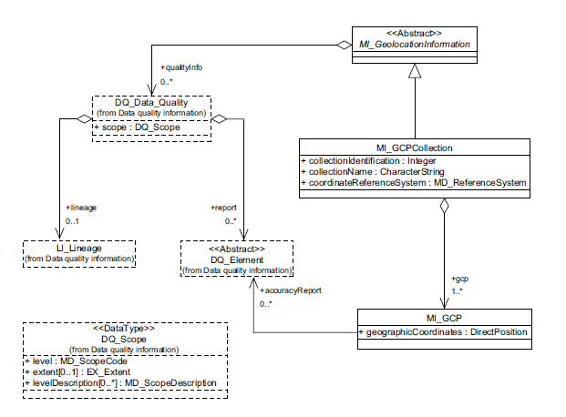
Ground Control Point Quality
Provides information relevant to the quality of GCPs.
Content Information
19115-2 provides extensions to allow for description of the content of imagery and gridded data datasets.

Acquisition Information
Acquisition Overview
Acquisition Overview pertains to the metadata classes required to define the acquisition of imagery and gridded datasets.
Acquisition Details
Acquisition Details contains means to document the specific acquisition of imagery and gridded datasets.

Overview
Content Tools