Element Description
The Tiling Identification System element defines a named two-dimensional tiling system related to the collection.
Best Practices
A tiling identification system is a defined 2-D grid which covers the surface of the Earth. An example of a tiling identification system is the Worldwide Reference System (WRS) where the surface of the Earth is split into numbered paths and rows. The WRS-2 system is used to catalog Landsat data and is a popular way to search for Landsat data. Another example are the various MODIS grids, such as the MODIS Sinusoidal Tile Grid system which divides the Earth into 595 10 x 10 degree tiles.
There are five sub-elements used to specify a tiling identification system. If provided, all of the sub-fields are required:
Tiling Identification System Name: This field identifies the name of the tiling identification system. The name must be selected from a controlled enumeration list which includes the following values: CALIPSO, MISR, MODIS Tile EASE, MODIS Tile SIN, WELD Alaska Tile, WELD CONUS Tile, WRS-1, WRS-2
Coordinate 1/ Minimum Value: Identifies the minimum value for one dimension (e.g. horizontal) of the two dimensional tiling system.
Coordinate 1/ Maximum Value: Identifies the maximum value for one dimension (e.g. horizontal) of the two dimensional tiling system.
Coordinate 2/ Minimum Value: Identifies the minimum value for the other dimension (e.g. vertical) of the two dimensional tiling system.
Coordinate 2/ Maximum Value: Identifies the maximum value for the other dimension (e.g. vertical) of the two dimensional tiling system.
Examples:
TilingIdentificationSystemName: MISR
Coordinate1/MinimumValue: 1
Coordinate2/MaximumValue: 233
Coordinate2/MinimumValue: 1
Coordinate2/MaximumValue: 80
TilingIdentificationSystemName: MODIS Tile SIN
Coordinate1/MinimumValue: 0
Coordinate2/MaximumValue: 35
Coordinate2/MinimumValue: 0
Coordinate2/MaximumValue: 17
Element Specification
Providing a Tiling Identification System is optional. An unlimited amount of Tiling Identification Systems may be provided (Cardinality: 0..*)
| Model | Element | Type | Usable Valid Values | Constraints | Required? | Cardinality | Notes |
|---|---|---|---|---|---|---|---|
| UMM-Common | TilingIdentificationSystem/TilingIdentificationSystemName | Enumeration | CALIPSO MISR MODIS Tile EASE MODIS Tile SIN WELD Alaska Tile WELD CONUS Tile WRS-1 WRS-2 | n/a | Yes, if applicable | 1 | Location of the TilingIdentificationSystemNameEnum in the UMM version 1.10.0 schema: https://git.earthdata.nasa.gov/projects/EMFD/repos/unified-metadata-model/browse/collection/v1.10/umm-cmn-json-schema.json#1580 |
| UMM-Common | TilingIdentificationSystem/Coordinate1/MinimumValue | Number | n/a | n/a | Yes, if applicable | 1 | |
| UMM-Common | TilingIdentificationSystem/Coordinate1/MaximumValue | Number | n/a | n/a | Yes, if applicable | 1 | |
| UMM-Common | TilingIdentificationSystem/Coordinate2/MinimumValue | Number | n/a | n/a | Yes, if applicable | 1 | |
| UMM-Common | TilingIdentificationSystem/Coordinate2/MaximumValue | Number | n/a | n/a | Yes, if applicable | 1 |
Metadata Validation and QA/QC
All metadata entering the CMR goes through the below process to ensure metadata quality requirements are met. All records undergo CMR validation before entering the system. The process of QA/QC is slightly different for NASA and non-NASA data providers. Non-NASA providers include interagency and international data providers and are referred to as the International Directory Network (IDN).
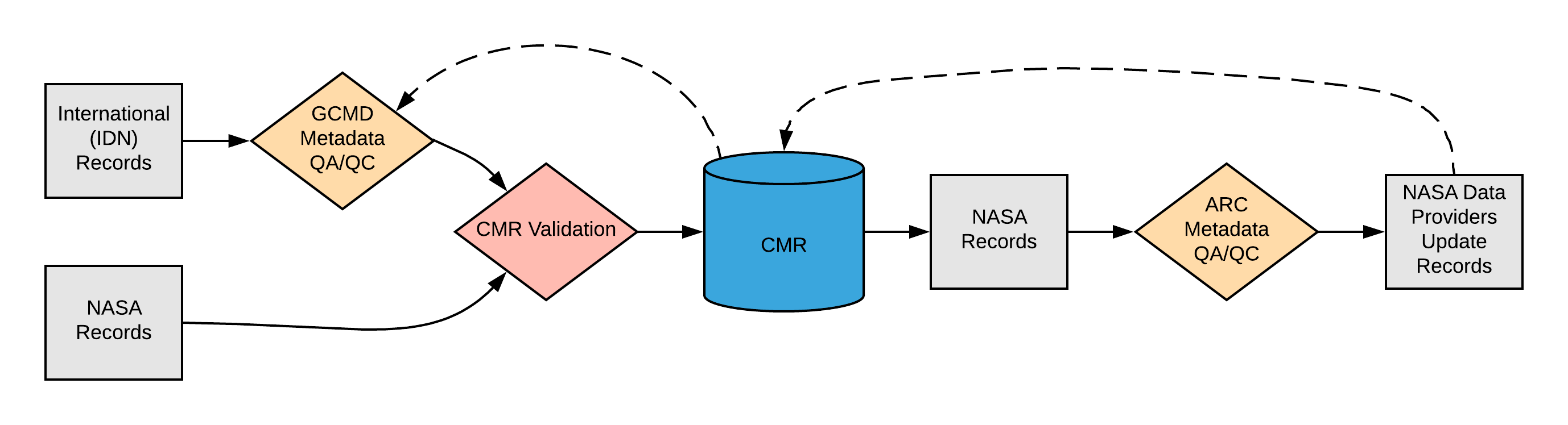
Please see the expandable sections below for flowchart details.
|
<> |
ARC Automated Rules
|
Dialect Mappings
DIF 9 (Note: DIF-9 is being phased out and will no longer be supported after 2018) |
DIF 10Providing a TwoD_Coordinate_System is optional. An unlimited amount of TwoD_Coordinate_Systems may be provided (Cardinality: 0..*)
|
ECHO 10Providing a TwoDCoordinateSystem is optional. An unlimited amount of TwoDCoordinateSystems may be provided (Cardinality: 0..*)
|
ISO 19115-2 MENDSProviding a Tiling Identification System is optional. An unlimited amount of Tiling Identification Systems may be provided (Cardinality: 0..*)
|
ISO 19115-2 SMAPProviding a Tiling Identification System is optional. An unlimited amount of Tiling Identification Systems may be provided (Cardinality: 0..*)
Example Mapping
|
UMM Migration
| UMM Version 1.9.0 | Translation Direction | UMM Version 1.10.0 |
|---|---|---|
Future Mappings
|
History
UMM Versioning
| Version | Date | What Changed |
|---|---|---|
| 1.14.0 | 10/21/2019 | No changes were made for Tiling Identification System during the transition from version 1.13.0 to 1.14.0 |
| 1.13.0 | 04/11/2019 | No changes were made for Tiling Identification System during the transition from version 1.12.0 to 1.13.0 |
| 1.12.0 | 01/22/2019 | No changes were made for Tiling Identification System during the transition from version 1.11.0 to 1.12.0. |
| 1.11.0 | 11/28/2018 | No changes were made for Tiling Identification System during the transition from version 1.10.0 to 1.11.0. |
| 1.10.0 | 05/02/2018 | During the transition from version 1.9.0 to 1.10.0, an enumeration list was created for Tiling Identification System. Values in the enumeration include: CALIPSO, MISR, MODIS Tile EASE, MODIS Tile SIN, WELD Alaska Tile, WELD CONUS Tile, WRS-1, WRS-2. |
| 1.9.0 |
ARC Documentation
| Version | Date | What Changed | Author |
|---|---|---|---|
| 1.0 | 10/26/2018 | Recommendations/priority matrix transferred from internal ARC documentation to wiki space | Jeanne' le Roux |