Element Description
The Track element provides orbit information for data collected via satellite including Cycle, Pass, and Tiles. This allows for file level searches on these orbital parameters. Track is a recently added element that is only available at the granule level.
Best Practices
The Track element was designed to support the Surface Water and Ocean Topography (SWOT) mission managed by NASA's PO.DAAC data center, however, this concept can be applied to any data that can be described using orbital cycles, passes, and tiles. There are three main components to the Track element:
- Cycle: A cycle is an integer that represents data from a specific set of satellite orbits. What constitutes a full cycle will vary from mission to mission. Typically, a cycle includes a full set of spatially varied data - a new cycle indicates that the spatial pattern of data collection is being repeated. For example, for the SWOT mission, a cycle is equivalent to 21 days of data made up of 14 full Earth orbits per day. Each of these orbits covers a slightly different spatial extent, and the exact same spatial area is not covered again until the next cycle. The cycle number also inherently includes a temporal component, since each cycle number indicates the passage of time (i.e. data from the 2nd cycle is collected after the 1st cycle, etc.).
- Pass: A pass includes data from a half-orbit. Each spatially unique pass should be assigned a unique identifier, and thus, the pass is represented by an integer. Each pass is made up of a number of tiles, which are assigned identifiers based on their unique spatial location. A granule may be comprised of data from a single pass, or multiple passes.
- Tiles: A tile is a subset of a pass' spatial extent. A set of consecutive tiles make up a pass. Each spatially unique tile has a unique identifier. The tile element holds the list of tile identifier(s) that exist in the granule, allowing a user to search by tile identifier. What constitutes a tile will vary from mission to mission. For example, for the SWOT mission, a tile is defined as a spatial extent that encompasses either a 64 km x 64 km square to the left or to the right of the ground track, or a rectangle that includes a full scanning swath both to the left and right of the ground track.
Each tile is contained within a pass (half-orbit), which is contained within a cycle. There will only be one instance of a particular pass number and tile identifier in a given cycle, therefore, the combination of tile, pass, and cycle can be used to constrain a data search.
Examples:
| Example 1: A granule from cycle 1 containing 2 passes, where each pass includes 12 tiles | A granule from cycle 12, containing 4 passes, where each pass contains 4 tiles |
|---|---|
Track: Cycle: 1 Passes: Pass: 34 Tiles: ["396", "397", "398", "399", "400", "401", "402", "403", "404", "405", "406", "407"] Pass: 35 Tiles: ["408", "409", "410", "411", "412, "413", "414", "415", "416", "417", "418", "419"] | Track: Cycle: 12 Passes: Pass: 1 Tiles: ["1L", "2R", "3L", "4R"] Pass: 2 Tiles: ["5L", "6R", "7L", "8R"] Pass: 3 Tiles: ["9L", "10R", "11L", "12R"] Pass: 4 Tiles: ["13L", "14R", "15L", "16R"] |
Element Specification
Track is an optional element in the UMM-G (Cardinality: 0..1)
| Model | Element | Type | Constraints | Required? | Cardinality | Notes |
|---|---|---|---|---|---|---|
| UMM-G | SpatialExtent/Track/Cycle | Integer | n/a | Yes, if applicable | 1 | Track is an optional metadata element. If provided, it is required that cycle, pass information be included. |
| UMM-G | SpatialExtent/Track/Passes/Pass | Integer | n/a | Yes, if applicable | 1..* | A minimum of 1 pass number must be provided. |
| UMM-G | SpatialExtent/Track/Passes/Tiles | Array composed of Strings | n/a | No | 0..* | Listing the tile identifiers within a pass is optional, but highly recommended. |
Metadata Validation and QA/QC
All metadata entering the CMR goes through the below process to ensure metadata quality requirements are met. All records undergo CMR validation before entering the system. The process of QA/QC is slightly different for NASA and non-NASA data providers. Non-NASA providers include interagency and international data providers and are referred to as the International Directory Network (IDN).
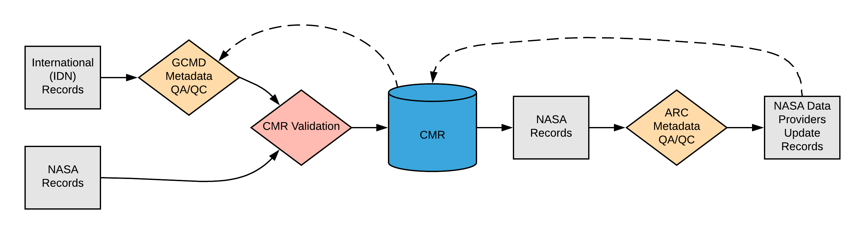
Please see the expandable sections below for flowchart details.
<> |
ARC Automated Checks ARC uses the pyQuARC library for automated metadata checks. Please see the pyQuARC GitHub for more information. |
Dialect Mappings
ECHO 10The Track element does not exist in ECHO 10. Example Mapping None, since ECHO 10 doesn't support the Track element. |
ISO 19115-2 MENDSSpatial Extent - Track is optional in ISO 19115-2 MENDS.
|
ISO 19115-2 SMAPSpatial Extent-Track currently does not map to ISO 19115-2 SMAP.
|
UMM Migration
| UMM Version 1.4.0 | Translation Direction | UMM Version 1.5.0 |
|---|---|---|
Future Mappings
|
History
UMM Versioning
| Version | Date | What Changed |
|---|---|---|
| 1.6.0 | 11/4/2019 | No changes were made for Track during the transition from version 1.5.0 to 1.6.0. |
| 1.5.0 | 01/30/2019 | The Track element was added to the UMM-G schema during the transition from version 1.4.0 to 1.5.0. |
| 1.4.0 | 08/01/2018 | Track was not available in version 1.4.0. |
ARC Documentation
| Version | Date | What Changed | Author |
|---|---|---|---|
| 1.0 | 04/02/2019 | Recommendations/priority matrix transferred from internal ARC documentation to wiki space |