Element Description
The Spatial Information element stores information about the reference frame from which horizontal and vertical spatial domains are measured. The horizontal reference frame includes fields for Geodetic Model, Geographic Coordinates, and Local Coordinates. The Vertical reference frame includes fields for altitudes (elevations) and depths.
Best Practices
Providing Spatial Information is optional, but encouraged. This element can be used to provide horizontal and/or vertical coordinate system information.
The Spatial Coverage Type field is required for Spatial Information.
Spatial Coverage Type: Denotes the type of spatial coverage of the collection. While this field is not currently controlled, recommend providing one of the spatial coverage type enumeration values: EARTH/GLOBAL, HORIZONTAL, VERTICAL, ORBITAL, HORIZONTAL_VERTICAL, ORBITAL_VERTICAL, HORIZONTAL_ORBITAL, HORIZONTAL_VERTICAL_ORBITAL, LUNAR
Vertical Spatial Information
The following sub-elements can be used to describe Vertical Coordinate Systems.
There are 2 categories for Vertical Coordinate Systems including:
(1) Altitude System Definition
Altitude System Definition should be used to describe data with a vertical component that is above-ground. Sub-elements under Altitude System Definition are summarized below:
- Datum Name: The name of the vertical datum the data is encoded in. Vertical datums define a level reference surface from which vertical measurements are compared. There are many standard vertical datums. If a standard vertical datum is used, it is recommended that the EPSG vertical datum name be provided.
- Distance Units: The units in which altitude measurements are recorded. This field is controlled and must be selected from one of the following values: HectoPascals, Kilometers, Millibars
- Resolutions: The minimum distance possible between two adjacent values, expressed in distance units of measure for the collection.
(2) Depth System Definition
Depth System Definition should be used to describe data with a vertical component that is below-ground. Sub-elements under Depth System Definition are summarized below:
- Datum Name: The name of the vertical datum the data is encoded in. Vertical datums define a level reference surface from which vertical measurements are compared. There are many standard vertical datums. If a standard vertical datum is used, it is recommended that the EPSG vertical datum name be provided.
- Distance Units: The units in which depth measurements are recorded. This field is controlled and must be selected from one of the following values: Fathoms, Feet, HectoPascals, Meters, Millibars
- Resolutions: The minimum distance possible between two adjacent values, expressed in distance units of measure for the collection.
- Datum Name: The name of the vertical datum the data is encoded in. Vertical datums define a level reference surface from which vertical measurements are compared. There are many standard vertical datums. If a standard vertical datum is used, it is recommended that the EPSG vertical datum name be provided.
Element Specification
Providing Spatial Information is optional (Cardinality: 0..1)
| Model | Element | Type | Usable Valid Values | Constraints | Required? | Cardinality | Notes |
|---|---|---|---|---|---|---|---|
| UMM-C | SpatialInformation/SpatialCoverageType | String | EARTH/GLOBAL, HORIZONTAL, VERTICAL, ORBITAL, HORIZONTAL_VERTICAL, ORBITAL_VERTICAL, HORIZONTAL_ORBITAL, HORIZONTAL_VERTICAL_ORBITAL, LUNAR | 1 - 80 characters | Yes, if applicable | 1 | |
| UMM-C | SpatialInformation/VerticalCoordinateSystem/AltitudeSystemDefinition/DatumName | String | n/a | 1 - 80 characters | No | 0..1 | Recommend providing EPSG vertical datum names |
| UMM-C | SpatialInformation/VerticalCoordinateSystem/AltitudeSystemDefinition/DistanceUnits | Enumeration | HectoPascals Kilometers Millibars | n/a | No | 0..1 | |
| UMM-C | SpatialInformation/VerticalCoordinateSystem/AltitudeSystemDefinition/Resolutions | Number | n/a | n/a | No | 0..* | |
| UMM-C | SpatialInformation/VerticalCoordinateSystem/DepthSystemDefinition/DatumName | String | n/a | 1 - 80 characters | No | 0..1 | Recommend providing EPSG vertical datum names |
| UMM-C | SpatialInformation/VerticalCoordinateSystem/DepthSystemDefinition/DistanceUnits | Enumeration | Fathoms Feet HectoPascals Meters Millibars | n/a | No | 0..1 | |
| UMM-C | SpatialInformation/VerticalCoordinateSystem/DepthSystemDefinition/Resolutions | Number | n/a | n/a | No | 0..* |
Metadata Validation and QA/QC
All metadata entering the CMR goes through the below process to ensure metadata quality requirements are met. All records undergo CMR validation before entering the system. The process of QA/QC is slightly different for NASA and non-NASA data providers. Non-NASA providers include interagency and international data providers and are referred to as the International Directory Network (IDN).
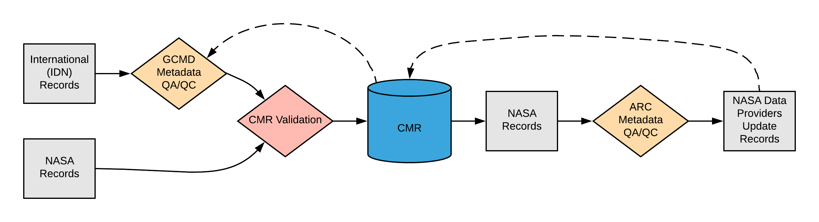
Please see the expandable sections below for flowchart details.
|
None |
ARC Automated Checks ARC uses the pyQuARC library for automated metadata checks. Please see the pyQuARC GitHub for more information. |
Dialect Mappings
DIF 10Providing Spatial_Info is optional in DIF 10 (Cardinality: 0..1). Note: There are no Vertical Coordinate System fields in DIF 10 - vertical information can be provided in the Vertical_Spatial_Info element. For details on Vertical_Spatial_Info please see the Spatial Extent wiki page. DIF 10 also supports an element called Data_Resolution which does not currently map to the UMM, however, there are plans to support it in the future.
|
ECHO 10Providing the Spatial Info element is optional in ECHO 10 (Cardinality: 0..1)
|
UMM Migration
N/A
History
UMM Versioning
| Version | Date | What Changed |
|---|---|---|
| 1.18.0 | 2024-03-18 | Updated Spatial Coverage Type enumeration list for 1.18.0 |
| 1.15.5 | 2020-12-03 | No changes were made for Spatial Information during the transition from version 1.15.4 to 1.15.5 |
| 1.15.4 | 2020-09-18 | No changes were made for Spatial Information during the transition from version 1.15.3 to 1.15.4 |
| 1.15.3 | 2020-07-01 | No changes were made for Spatial Information during the transition from version 1.15.2 to 1.15.3 |
| 1.15.2 | 2020-05-20 | No changes were made for Spatial Information during the transition from version 1.15.1 to 1.15.2 |
| 1.15.1 | 2020-03-25 | No changes were made for Spatial Information during the transition from version 1.15.0 to 1.15.1 |
| 1.15.0 | 2020-02-26 | No changes were made for Spatial Information during the transition from version 1.14.0 to 1.15.0 |
| 1.14.0 | 2019-10-21 | The Horizontal Coordinate System element and all supporting elements were either removed or renamed and moved to the SpatialExtent element. |
| 1.13.0 | 2019-04-11 | No changes were made for Spatial Information during the transition from version 1.12.0 to 1.13.0 |
| 1.12.0 | 2019-01-22 | No changes were made for Spatial Information during the transition from version 1.11.0 to 1.12.0. |
| 1.11.0 | 2018-11-28 | No changes were made for Spatial Information during the transition from version 1.10.0 to 1.11.0. |
| 1.10.0 | 2018-05-02 | During the transition from version 1.9.0 to 1.10.0:
|
ARC Documentation
| Version | Date | What Changed | Author |
|---|---|---|---|
| 1.0 | 2019-02-15 | Recommendations/priority matrix transferred from internal ARC documentation to wiki space |