Element Description

The Additional Attribute element is used to describe unique characteristics of the resource which extend beyond those defined in other metadata fields.


Best Practices

The Additional Attributes metadata concept can be used to describe unique characteristics of a dataset beyond what is covered in the existing metadata model. For example: cloud cover, tile number, or acquisition mode could be provided as additional attributes, since there are no existing metadata fields for these particular characteristics in the Unified Metadata Model (UMM). All Additional Attributes must be defined in the collection level metadata and should also be provided in the granule level metadata. If an additional attribute in the granule level metadata has not been defined in the parent collection, then validation errors may occur.

There are twelve sub-elements that comprise Additional Attributes:

Name: The name/ label for the additional attribute. Providing a name is required.

Description: A free-text description of the additional attribute. Providing a description is required.

Value: The value of the additional attribute. Provide the value in the collection level record if it is the same for all granules in the collection. If the value of the additional attribute differs by granule, then leave the value field blank at the collection level (see below for examples).

DataType: The data type of the additional attribute value. Providing a data type is required. This is a controlled vocabulary field in UMM-Common with the following options: STRING, FLOAT, INT, BOOLEAN, DATE, TIME, DATETIME, DATE_STRING, TIME_STRING, DATETIME_STRING

Measurement Resolution: The smallest unit increment to which the additional attribute value is measured. Providing a measurement resolution is optional.

Parameter Range Begin: The minimum value of the additional attribute over the whole collection. This only applies to attributes that are continuous in nature. Providing a parameter range begin is optional.

Parameter Range End: The maximum value of the additional attribute over the whole collection. This only applies to attributes that are continuous in nature. Providing a parameter range end is optional.

Parameter Units Of Measure: The standard unit of measurement for the additional attribute. For example: meters, hertz. Providing a parameter unit of measure is optional, but is highly recommended if the additional attribute value has an associated unit. Use of SI Base Units are recommended: https://www.nist.gov/pml/weights-and-measures/metric-si/si-units

Parameter Value Accuracy: An estimate of the accuracy of the values of the additional attribute. The accuracy must be specified as a percentage or the unit with which the parameter is measured. Providing a parameter value accuracy is optional.

Value Accuracy Explanation: Describes the method used for determining the parameter value accuracy. Providing a value accuracy explanation is optional.

Group: Identifies a namespace for the additional attribute name. Providing a group is optional. 

Update Date: The date this additional attribute information was updated. Providing an update date is optional. 


The Additional Attribute Value might be the same for all data in a collection, or it may vary. This results in 2 possible scenarios:

Scenario 1

The Additional Attribute value is the same for all data in the collection. In this case, the additional attribute "Value" field should be populated in the collection level metadata. Populating the "Value" field at the collection level indicates that the value is the same for all granules in the collection. For example, if cloud cover is the same (let's say 50%) for the entire dataset, the metadata would look like this:

Example 1: Additional Attribute that is the same for all granules in a dataset. Note that the value field is populated at the collection level and that the value remains the same at the granule level. 

Collection Level MetadataGranule Level Metadata file 1Granule Level Metadata file 2

"AdditionalAttributes": [

   {

     "Name": "Cloud Cover",

     "Description": "Percent cloud cover",

     “Value”: “50”,

     "DataType": "INT",

“ParameterUnitsOfMeasure”: “Percent

   },

"AdditionalAttributes": [

   {

     "Name": "Cloud Cover",

     “Value”: “50”,

   },

"AdditionalAttributes": [

   {

     "Name": "Cloud Cover",

     “Value”: “50”,

   },


Scenario 2

The Additional Attribute value varies across the collection. In this case, the additional attribute "Value" field should be left blank in the collection level metadata. Excluding the "Value" field at the collection level indicates that the value changes from granule to granule, and that the granule level metadata should be referenced to determine the value of the attribute for that particular data file. For example, if cloud cover varies across the dataset, the metadata would look like this:

Example 2: Additional Attribute that varies from granule to granule. Note that the value field is not provided at the collection level and that the value is different for each of the granules. 

Collection Level MetadataGranule Level Metadata file 1Granule Level Metadata file 2

"AdditionalAttributes": [

   {

     "Name": "Cloud Cover",

     "Description": "Percent cloud cover",

     "DataType": "INT",

“ParameterUnitsOfMeasure”: “Percent

   },

"AdditionalAttributes": [

   {

     "Name": "Cloud Cover",

     “Value”: “30”,

   },

"AdditionalAttributes": [

   {

     "Name": "Cloud Cover",

     “Value”: “73”,

   },


Examples: 

Name"Polarization"

Description: "Transmit and receive polarization specification for the SAR file"

Value"HV"

Data Type"STRING"


Name: "Band Center Frequency"

Description: "Central transmission frequency of the instrument"

Data Type: "FLOAT"

ParameterUnitsOfMeasure: "GHz"


Name: "MODIS SIN TILE HORIZ"

Description: "The horizontal tile number of the MODIS sinusoidal tile grid"

Type: "INT"

ParameterRangeBegin: "0"

ParameterRangeEnd: "35"


Element Specification

Providing the Additional Attributes element is optional (Cardinality: 0..*)

ModelElementTypeConstraintsRequired?CardinalityNotes
UMM-CAdditionalAttribute/NameString

1 - 50 characters

Yes1
UMM-CAdditionalAttribute/DescriptionString

1 - 2048 characters

Yes1
UMM-CAdditionalAttribute/ValueString

1 - 500 characters

No0..1
UMM-CAdditionalAttribute/DataTypeEnumeration

STRING

FLOAT

INT

BOOLEAN

DATE

TIME

DATETIME

DATE_STRING

TIME_STRING

DATETIME_STRING

Yes1
UMM-CAdditionalAttribute/MeasurementResolutionString

1 - 80 characters

No0..1
UMM-CAdditionalAttribute/ParameterRangeBeginString

1 - 80 characters

No0..1
UMM-CAdditionalAttribute/ParameterRangeEndString

1 - 80 characters

No0..1
UMM-CAdditionalAttribute/ParameterUnitsOfMeasureString

1 - 80 characters

No0..1
UMM-CAdditionalAttribute/ParameterValueAccuracyString

1 - 80 characters

No0..1
UMM-CAdditionalAttribute/ValueAccuracyExplanationString

1 - 2048 characters

No0..1
UMM-CAdditionalAttribute/GroupString

1 - 50 characters

No0..1
UMM-CAdditionalAttribute/UpdateDatedate-time

N/A

No0..1Dates must comply with the ISO 8601 Standard.

Metadata Validation and QA/QC

All metadata entering the CMR goes through the below process to ensure metadata quality requirements are met. All records undergo CMR validation before entering the system. The process of QA/QC is slightly different for NASA and non-NASA data providers. Non-NASA providers include interagency and international data providers and are referred to as the International Directory Network (IDN).

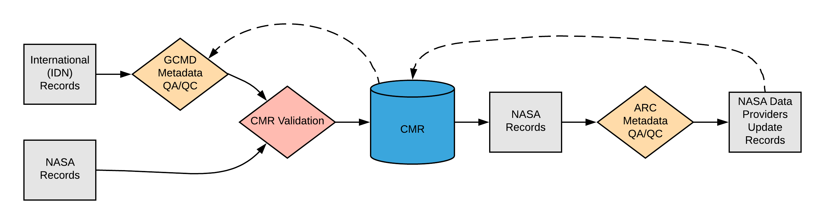
Please see the expandable sections below for flowchart details.


  • Manual Review
    • Identify errors, discrepancies or omissions.
    • Proof all content for conciseness and readability.
  • Automated Review
    • Checks that the field length is not greater than that established in the schema for each "Additional Attribute" sub-group. 
    • Checks "DIF/Additional_Attributes/DataType" for enumerations; "STRING", "FLOAT", "INT", "BOOLEAN", "DATE", "TIME", "DATETIME", "DATE_STRING", "TIME_STRING", "DATETIME_STRING".

Checks to determine if string falls within maximum field lengths. 

ARC Priority Matrix

Priority CategorizationJustification

Red = High Priority Finding

This element is categorized as highest priority when:

  • Any Additional Attribute sub-element contains a major spelling or grammatical error.
  • An incorrect or invalid Additional Attribute/Data Type is provided.
  • An Additional Attribute is provided at the granule level that is not defined at the collection level.

Yellow = Medium Priority Finding

This element is categorized as medium priority when:

  • A recommendation is made to improve the readability and/or consistency of the Additional Attribute. 

Blue = Low Priority Finding

This element is categorized as low priority when:

  • The Additional Attribute contains a URL which needs to be updated from http to https.
  • Any other miscellaneous suggestions (minor in nature).

Green = No Findings/Issues

The element is provided and follows all applicable criteria specified in the best practices section above.

ARC Automated Checks

ARC uses the pyQuARC library for automated metadata checks. Please see the pyQuARC GitHub for more information. 

Dialect Mappings

DIF 9 (Note: DIF-9 is being phased out and will no longer be supported after 2018)

DIF 10

Providing the Additional_Attributes element is optional in DIF 10 (Cardinality: 0..*)

DIF 10 also supports an element called Extended_Metadata which cross-walks to Additional Attributes when being converted from DIF 10 to the UMM. Providing the Extended_Metadata element is optional (Cardinality: 0..*).

UMM-C ElementDIF 10 PathTypeConstraintsRequired in DIF 10?CardinalityNotes
AdditionalAttribute/GroupExtended_Metadata/Metadata/Group

String


No

0..1
AdditionalAttribute/NameExtended_Metadata/Metadata/NameString
Yes1
AdditionalAttribute/DataTypeExtended_Metadata/Metadata/TypeString
No0..1
AdditionalAttribute/DescriptionExtended_Metadata/Metadata/DescriptionString
No0..1

"AdditionalAttribute/Description" is required by the UMM. If no description is provided in the extended metadata, a value of "Not provided" will automatically be populated in the "AdditionalAttribute/Description" field upon conversion from DIF 10 to the UMM-JSON metadata standard.

AdditionalAttribute/UpdateDateExtended_Metadata/Metadata/Update_DateString
No0..1
AdditionalAttribute/ValueExtended_Metadata/Metadata/ValueString
No0..*
Additional_Attributes/NameAdditional_Attributes/NameString
Yes1
AdditionalAttribute/DataTypeAdditional_Attributes/DataTypeString
Yes1This sub element "Path/Type" will change from "String" to "Enumeration" in future versions. The usable valid values for the enumeration will map to UMM-C (STRING,FLOAT, INT, BOOLEAN, DATE, TIME, DATETIME, DATE_STRING, TIME_STRING, DATETIME_STRING)
AdditionalAttribute/DescriptionAdditional_Attributes/DescriptionString
Yes 0..1
AdditionalAttribute/MeasurementResolutionAdditional_Attributes/MeasurementResolutionString
No0..1
AdditionalAttribute/ParameterRangeBeginAdditional_Attributes/ParameterRangeBeginString
Yes 0..1
AdditionalAttribute/ParameterRangeEndAdditional_Attributes/ParameterRangeEndString
No0..1
AdditionalAttribute/ParameterUnitsOfMeasureAdditional_Attributes/ParameterUnitsOfMeasureString
No0..1
AdditionalAttribute/ParameterValueAccuracyAdditional_Attributes/ParameterValueAccuracyString
No0..1
AdditionalAttribute/ValueAccuracyExplanationAdditional_Attributes/ValueAccuracyExplanationString
No0..1
AdditionalAttribute/ValueAdditional_Attributes/ValueString
No0..1


Example Mapping

DIF 10

<Additional_Attributes>
  <Name>Geolocated</Name>
  <Description>Denotes whether the data is geolocated.</Description>
  <DataType>STRING</DataType>
  <Value>False</Value>
</Additional_Attributes>
<Additional_Attributes>
  <Name>Laser Footprint</Name>
  <Description>The diameter of the laser beam that reaches the ground.</Description>
  <DataType>FLOAT</DataType>
  <ParameterUnitsOfMeasure>Meters</ParameterUnitsOfMeasure>
</Additional_Attributes>
------------------- with --------------------------
<Extended_Metadata>
  <Metadata>
    <Group>gov.nasa.gsfc.gcmd</Group>
    <Name>metadata.keyword_version</Name>
    <Value>8.1</Value>
  </Metadata>
  <Metadata>
    <Group>gov.nasa.gsfc.disc</Group>
    <Name>Data Granularity</Name>
    <Description>The time coverage of individual data granules.</Description>
    <Value>1 day</Value>
  </Metadata>
</Extended_Metadata>

UMM

"AdditionalAttributes": [    
    {
      “Value”: “False”,      
      "Name": "Geolocated",
      "Description": "Denotes whether the data is geolocated.",
      "DataType": "STRING"
    },
    {
      "Name": "Laser Footprint",
      "Description": "The diameter of the laser beam that reaches the ground.",
      "DataType": "FLOAT",
      “ParameterUnitsOfMeasure”: “Meters”
    },
    {
      "Group": "gov.nasa.gsfc.gcmd",
      “Value”: “8.1”,      
      "Name": "metadata.keyword_version",
      "Description": "Not provided"
    },
    {
      "Group": "gov.nasa.gsfc.disc",
      “Value”: “1 day”,      
      "Name": "Data Granularity",
      "Description": "The time coverage of individual data granules."
    }
]

ECHO 10

Providing the Additional Attributes element is optional (Cardinality: 0..*)

UMM-C ElementECHO 10 PathTypeConstraintsRequired in ECHO10?Cardinality
AdditionalAttribute/NameAdditionalAttributes/AdditionalAttribute/NameString

1 - 80 characters

Yes1
AdditionalAttribute/DataTypeAdditionalAttributes/AdditionalAttribute/DataTypeEnumeration

STRING

FLOAT

INT

BOOLEAN

DATE

TIME

DATETIME

DATE_STRING

TIME_STRING

Yes1
AdditionalAttribute/DescriptionAdditionalAttributes/AdditionalAttribute/DescriptionString1 - 2048 charactersYes1
AdditionalAttribute/MeasurementResolutionAdditionalAttributes/AdditionalAttribute/MeasurementResolutionString1 - 80 charactersNo0..1
AdditionalAttribute/ParameterRangeBeginAdditionalAttributes/AdditionalAttribute/ParameterRangeBeginString1 - 80 charactersNo0..1
AdditionalAttribute/ParameterRangeEndAdditionalAttributes/AdditionalAttribute/ParameterRangeEndString1 - 80 charactersNo0..1
AdditionalAttribute/ParameterUnitsOfMeasureAdditionalAttributes/AdditionalAttribute/ParameterUnitsOfMeasureString1 - 80 charactersNo0..1
AdditionalAttribute/ParameterValueAccuracyAdditionalAttributes/AdditionalAttribute/ParameterValueAccuracyString1 - 80 charactersNo0..1
AdditionalAttribute/ValueAccuracyExplanationAdditionalAttributes/AdditionalAttribute/ValueAccuracyExplanationString1 - 2048 charactersNo0..1
AdditionalAttribute/ValueAdditionalAttributes/AdditionalAttribute/ValueString1 - 500 charactersNo0..1


Example Mapping

ECHO 10

<AdditionalAttributes>
  <AdditionalAttribute>
    <Name>Geolocated</Name>
    <DataType>STRING</DataType>
    <Description>Denotes whether the data is geolocated.</Description>
    <Value>False</Value>
  </AdditionalAttribute>
  <AdditionalAttribute>
    <Name>Laser Footprint</Name>
    <DataType>FLOAT</DataType>
    <Description>The diameter of the laser beam that reaches the ground.</Description>
    <ParameterUnitsOfMeasure>Meters</ParameterUnitsOfMeasure>
  </AdditionalAttribute>
</Additional_Attributes>  

UMM

"AdditionalAttributes": [    
    {
      “Value”: “False”,      
      "Name": "Geolocated",
      "Description": "Denotes whether the data is geolocated.",
      "DataType": "STRING"
    },
    {
      "Name": "Laser Footprint",
      "Description": "The diameter of the laser beam that reaches the ground.",
      "DataType": "FLOAT",
      “ParameterUnitsOfMeasure”: “Meters”
    }
]

ISO 19115-2 MENDS

Disclaimer: ISO to UMM mapping for Additional Attributes subject to change

Providing the Additional Attributes element is optional (Cardinality: 0..*)

If the additional attribute type is known it can be mapped to the correct section of ISO.  Currently additional attributes are mapped to several sections within ISO depending on if the attribute is geographical, describes coverage, describes data quality, describes acquisition, or maps to a keyword.

UMM-C ElementISO PathType
AdditionalAttribute/Name
/gmi:MI_Metadata/gmd:dataQualityInfo/gmd:DQ_DataQuality/gmd:lineage/gmd:LI_Lineage/gmd:processStep/gmi:LE_ProcessStep/gmi:processingInformation/ eos:EOS_Processing/eos:otherProperty/gco:Record/eos:AdditionalAttributes/eos:AdditionalAttribute/eos:reference/eos:EOS_AdditionalAttributeDescription/ eos:name/gco:CharacterStringString
AdditionalAttribute/DataType
/gmi:MI_Metadata/gmd:dataQualityInfo/gmd:DQ_DataQuality/gmd:lineage/gmd:LI_Lineage/gmd:processStep/gmi:LE_ProcessStep/gmi:processingInformation/ eos:EOS_Processing/eos:otherProperty/gco:Record/eos:AdditionalAttributes/eos:AdditionalAttribute/eos:reference/eos:EOS_AdditionalAttributeDescription/ eos:dataType/eos:EOS_AdditionalAttributeDataTypeCode codeList="http://earthdata.nasa.gov/metadata/resources/Codelists.xml#EOS_AdditionalAttributeDataTypeCode" codeListValue="*dataType*">*dataType*</eos:EOS_AdditionalAttributeDataTypeCode>
where *dataType* = STRING,FLOAT,INT, etc.
String
AdditionalAttribute/Description
/gmi:MI_Metadata/gmd:dataQualityInfo/gmd:DQ_DataQuality/gmd:lineage/gmd:LI_Lineage/gmd:processStep/gmi:LE_ProcessStep/gmi:processingInformation/ eos:EOS_Processing/eos:otherProperty/gco:Record/eos:AdditionalAttributes/eos:AdditionalAttribute/eos:reference/eos:EOS_AdditionalAttributeDescription/eos:description/gco:CharacterStringString
AdditionalAttribute/MeasurementResolution
/gmi:MI_Metadata/gmd:dataQualityInfo/gmd:DQ_DataQuality/gmd:lineage/gmd:LI_Lineage/gmd:processStep/gmi:LE_ProcessStep/gmi:processingInformation/ eos:EOS_Processing/eos:otherProperty/gco:Record/eos:AdditionalAttributes/eos:AdditionalAttribute/eos:reference/eos:EOS_AdditionalAttributeDescription/ eos:measurementResolution/gco:CharacterStringString
AdditionalAttribute/ParameterRangeBegin/gmi:MI_Metadata/gmd:dataQualityInfo/gmd:DQ_DataQuality/gmd:lineage/gmd:LI_Lineage/gmd:processStep/gmi:LE_ProcessStep/gmi:processingInformation/ eos:EOS_Processing/eos:otherProperty/gco:Record/eos:AdditionalAttributes/eos:AdditionalAttribute/eos:reference/eos:EOS_AdditionalAttributeDescription/ eos:parameterRangeBegin/gco:CharacterStringString
AdditionalAttribute/ParameterRangeEnd/gmi:MI_Metadata/gmd:dataQualityInfo/gmd:DQ_DataQuality/gmd:lineage/gmd:LI_Lineage/gmd:processStep/gmi:LE_ProcessStep/gmi:processingInformation/ eos:EOS_Processing/eos:otherProperty/gco:Record/eos:AdditionalAttributes/eos:AdditionalAttribute/eos:reference/eos:EOS_AdditionalAttributeDescription/ eos:parameterRangeEnd/gco:CharacterStringString
AdditionalAttribute/ParameterUnitsOfMeasure/gmi:MI_Metadata/gmd:dataQualityInfo/gmd:DQ_DataQuality/gmd:lineage/gmd:LI_Lineage/gmd:processStep/gmi:LE_ProcessStep/gmi:processingInformation/ eos:EOS_Processing/eos:otherProperty/gco:Record/eos:AdditionalAttributes/eos:AdditionalAttribute/eos:reference/eos:EOS_AdditionalAttributeDescription/ eos:parameterUnitsOfMeasure/gco:CharacterStringString
AdditionalAttribute/ParameterValueAccuracy/gmi:MI_Metadata/gmd:dataQualityInfo/gmd:DQ_DataQuality/gmd:lineage/gmd:LI_Lineage/gmd:processStep/gmi:LE_ProcessStep/gmi:processingInformation/ eos:EOS_Processing/eos:otherProperty/gco:Record/eos:AdditionalAttributes/eos:AdditionalAttribute/eos:reference/eos:EOS_AdditionalAttributeDescription/ eos:parameterValueAccuracy/gco:CharacterStringString
AdditionalAttribute/ValueAccuracyExplanation/gmi:MI_Metadata/gmd:dataQualityInfo/gmd:DQ_DataQuality/gmd:lineage/gmd:LI_Lineage/gmd:processStep/gmi:LE_ProcessStep/gmi:processingInformation/ eos:EOS_Processing/eos:otherProperty/gco:Record/eos:AdditionalAttributes/eos:AdditionalAttribute/eos:reference/eos:EOS_AdditionalAttributeDescription/ eos:valueAccuracyExplanation/gco:CharacterStringString
AdditionalAttribute/Value/gmi:MI_Metadata/gmd:dataQualityInfo/gmd:DQ_DataQuality/gmd:lineage/gmd:LI_Lineage/gmd:processStep/gmi:LE_ProcessStep/gmi:processingInformation/ eos:EOS_Processing/eos:otherProperty/gco:Record/eos:AdditionalAttributes/eos:AdditionalAttribute/eos:value/gco:CharacterStringString


Example Mapping

ISO 19115-2 MENDS

<gmi:MI_Metadata>
...
  <gmd:dataQualityInfo>
    <gmd:DQ_DataQuality>
      <gmd:lineage>
        <gmd:LI_Lineage>
          <gmd:processStep>
            <gmi:LE_ProcessStep>
              <gmi:processingInformation>
                <eos:EOS_Processing>
                  <eos:otherProperty>
                    <gco:Record>
                      <eos:AdditionalAttributes>
                       <eos:AdditionalAttribute>
                         <eos:reference>
                         <eos:EOS_AdditionalAttributeDescription>
                           <eos:name>
                            <gco:CharacterString>Geolocated</gco:CharacterString>
                           </eos:name>
                           <eos:dataType>
                            <eos:EOS_AdditionalAttributeDataTypeCode codeList="http://earthdata.nasa.gov/metadata/resources/Codelists.xml#EOS_AdditionalAttributeDataTypeCode" codeListValue="STRING">STRING   
                            </eos:EOS_AdditionalAttributeDataTypeCode>
                           </eos:dataType>
                           <eos:description>
                            <gco:CharacterString>Denotes whether the data is geolocated.</gco:CharacterString>
                           </eos:description>
                         </eos:EOS_AdditionalAttributeDescription>
                         </eos:reference>
                         <eos:value>
                          <gco:CharacterString>False</gco:CharacterString>
                         </eos:value>
                       </eos:AdditionalAttribute> 
                     </eos:AdditionalAttributes>
                   </gco:Record>
                 </eos:otherProperty>
               </eos:EOS_Processing>
             </gmi:processingInformation>
           </gmi:LE_ProcessStep>
         </gmd:processStep>
       </gmd:LI_Lineage>
     </gmd:lineage>
    </gmd:DQ_DataQuality>
  </gmd:dataQualityInfo>
...
</gmi:MI_Metadata>

UMM

"AdditionalAttributes": [    
    {
      “Value”: “False”,      
      "Name": "Geolocated",
      "Description": "Denotes whether the data is geolocated.",
      "DataType": "STRING"
    },
]

ISO 19115-2 SMAP

Disclaimer: ISO to UMM mapping for Additional Attributes subject to change

Providing the Additional Attributes element is optional (Cardinality: 0..*)

UMM-C ElementISO PathType
AdditionalAttribute/Name

TBD

String

AdditionalAttribute/Name
TBDString
AdditionalAttribute/Type
TBDString
AdditionalAttribute/Identifier
TBDString
AdditionalAttribute/DataType
TBDString
AdditionalAttribute/Description
TBDString
AdditionalAttribute/MeasurementResolution
TBDString
AdditionalAttribute/ParameterRangeBegin
TBDString
AdditionalAttribute/ParameterRangeEnd
TBDString
AdditionalAttribute/ParameterUnitsOfMeasure
TBDString
AdditionalAttribute/ParameterValueAccuracy
TBDString
AdditionalAttribute/ValueAccuracyExplanation
TBDString


Example Mapping

ISO 19115-2 SMAP

<gmd:DS_Series>
<gmd:seriesMetadata>
<gmi:MI_Metadata>
...
  <gmd:dataQualityInfo>
    <gmd:DQ_DataQuality>
      <gmd:lineage>
        <gmd:LI_Lineage>
          <gmd:processStep>
            <gmi:LE_ProcessStep>
              <gmi:processingInformation>
                <eos:EOS_Processing>
                  <eos:otherProperty>
                    <gco:Record>
                      <eos:AdditionalAttributes>
                       <eos:AdditionalAttribute>
                         <eos:reference>
                         <eos:EOS_AdditionalAttributeDescription>
                           <eos:name>
                            <gco:CharacterString>Geolocated</gco:CharacterString>
                           </eos:name>
                           <eos:dataType>
                            <eos:EOS_AdditionalAttributeDataTypeCode codeList="http://earthdata.nasa.gov/metadata/resources/Codelists.xml#EOS_AdditionalAttributeDataTypeCode" codeListValue="STRING">STRING   
                            </eos:EOS_AdditionalAttributeDataTypeCode>
                           </eos:dataType>
                           <eos:description>
                            <gco:CharacterString>Denotes whether the data is geolocated.</gco:CharacterString>
                           </eos:description>
                         </eos:EOS_AdditionalAttributeDescription>
                         </eos:reference>
                         <eos:value>
                          <gco:CharacterString>False</gco:CharacterString>
                         </eos:value>
                       </eos:AdditionalAttribute> 
                     </eos:AdditionalAttributes>
                   </gco:Record>
                 </eos:otherProperty>
               </eos:EOS_Processing>
             </gmi:processingInformation>
           </gmi:LE_ProcessStep>
         </gmd:processStep>
       </gmd:LI_Lineage>
     </gmd:lineage>
    </gmd:DQ_DataQuality>
  </gmd:dataQualityInfo>
...
</gmi:MI_Metadata>
</gmd:seriesMetadata>
</gmd:DS_Series>

UMM

"AdditionalAttributes": [    
    {
      “Value”: “False”,      
      "Name": "Geolocated",
      "Description": "Denotes whether the data is geolocated.",
      "DataType": "STRING"
    },
]

UMM Migration

UMM Version 1.9.0Translation DirectionUMM Version 1.10.0


Future Mappings

ISO 19115-1

Disclaimer: ISO to UMM mapping for Additional Attributes subject to change

Providing the Additional Attributes element is optional (Cardinality: 0..*)

UMM-C ElementISO PathType
AdditionalAttribute/Namemdb:MD_Metadata/mdb:resourceLineage/mrl:LI_Lineage/mrl:source/mil:LE_Source/mrl:processStep/mil:LE_ProcessStep/mrl:processor/mil:processingInformation/ eos:EOS_Processing/eos:otherProperty/gco:Record/eos:AdditionalAttributes/eos:AdditionalAttribute/eos:reference/eos:EOS_AdditionalAttributeDescription/eos:name/gco:CharacterString

String

AdditionalAttribute/Namemdb:MD_Metadata/mdb:resourceLineage/mrl:LI_Lineage/mrl:source/mil:LE_Source/mrl:processStep/mil:LE_ProcessStep/mrl:processor/mil:processingInformation/ eos:EOS_Processing/eos:otherProperty/gco:Record/eos:AdditionalAttributes/eos:AdditionalAttribute/eos:reference/eos:EOS_AdditionalAttributeDescription/eos:type/eos:EOS_AdditionalAttributeTypeCode codeList="https://cdn.earthdata.nasa.gov/iso/resources/Codelist/eosCodelists.xml#EOS_AdditionalAttributeTypeCode" codeListValue="*type*">*type*
where *type* = processingInformation
String
AdditionalAttribute/Typemdb:MD_Metadata/mdb:resourceLineage/mrl:LI_Lineage/mrl:source/mil:LE_Source/mrl:processStep/mil:LE_ProcessStep/mrl:processor/mil:processingInformation/ eos:EOS_Processing/eos:otherProperty/gco:Record/eos:AdditionalAttributes/eos:AdditionalAttribute/eos:reference/eos:EOS_AdditionalAttributeDescription/eos:identifier/gmd:MD_Identifier/gmd:code/gco:CharacterStringString
AdditionalAttribute/Identifiermdb:MD_Metadata/mdb:resourceLineage/mrl:LI_Lineage/mrl:source/mil:LE_Source/mrl:processStep/mil:LE_ProcessStep/mrl:processor/mil:processingInformation/ eos:EOS_Processing/eos:otherProperty/gco:Record/eos:AdditionalAttributes/eos:AdditionalAttribute/eos:reference/eos:EOS_AdditionalAttributeDescription/eos:dataType/eos:EOS_AdditionalAttributeDataTypeCode codeList="http://earthdata.nasa.gov/metadata/resources/Codelists.xml#EOS_AdditionalAttributeDataTypeCode" codeListValue="*dataType*">*dataType*</eos:EOS_AdditionalAttributeDataTypeCode>
where *dataType* = STRING,FLOAT,INT, etc.
String
AdditionalAttribute/DataTypemdb:MD_Metadata/mdb:resourceLineage/mrl:LI_Lineage/mrl:source/mil:LE_Source/mrl:processStep/mil:LE_ProcessStep/mrl:processor/mil:processingInformation/ eos:EOS_Processing/eos:otherProperty/gco:Record/eos:AdditionalAttributes/eos:AdditionalAttribute/eos:reference/eos:EOS_AdditionalAttributeDescription/eos:description/gco:CharacterStringString
AdditionalAttribute/Descriptionmdb:MD_Metadata/mdb:resourceLineage/mrl:LI_Lineage/mrl:source/mil:LE_Source/mrl:processStep/mil:LE_ProcessStep/mrl:processor/mil:processingInformation/ eos:EOS_Processing/eos:otherProperty/gco:Record/eos:AdditionalAttributes/eos:AdditionalAttribute/eos:reference/eos:EOS_AdditionalAttributeDescription/eos:measurementResolution/gco:CharacterStringString
AdditionalAttribute/MeasurementResolutionmdb:MD_Metadata/mdb:resourceLineage/mrl:LI_Lineage/mrl:source/mil:LE_Source/mrl:processStep/mil:LE_ProcessStep/mrl:processor/mil:processingInformation/ eos:EOS_Processing/eos:otherProperty/gco:Record/eos:AdditionalAttributes/eos:AdditionalAttribute/eos:reference/eos:EOS_AdditionalAttributeDescription/eos:parameterRangeBegin/gco:CharacterStringString
AdditionalAttribute/ParameterRangeBeginmdb:MD_Metadata/mdb:resourceLineage/mrl:LI_Lineage/mrl:source/mil:LE_Source/mrl:processStep/mil:LE_ProcessStep/mrl:processor/mil:processingInformation/ eos:EOS_Processing/eos:otherProperty/gco:Record/eos:AdditionalAttributes/eos:AdditionalAttribute/eos:reference/eos:EOS_AdditionalAttributeDescription/eos:parameterRangeEnd/gco:CharacterStringString
AdditionalAttribute/ParameterRangeEndmdb:MD_Metadata/mdb:resourceLineage/mrl:LI_Lineage/mrl:source/mil:LE_Source/mrl:processStep/mil:LE_ProcessStep/mrl:processor/mil:processingInformation/ eos:EOS_Processing/eos:otherProperty/gco:Record/eos:AdditionalAttributes/eos:AdditionalAttribute/eos:reference/eos:EOS_AdditionalAttributeDescription/eos:parameterUnitsOfMeasure/gco:CharacterStringString
AdditionalAttribute/ParameterUnitsOfMeasuremdb:MD_Metadata/mdb:resourceLineage/mrl:LI_Lineage/mrl:source/mil:LE_Source/mrl:processStep/mil:LE_ProcessStep/mrl:processor/mil:processingInformation/ eos:EOS_Processing/eos:otherProperty/gco:Record/eos:AdditionalAttributes/eos:AdditionalAttribute/eos:reference/eos:EOS_AdditionalAttributeDescription/eos:parameterValueAccuracy/gco:CharacterStringString
AdditionalAttribute/ParameterValueAccuracymdb:MD_Metadata/mdb:resourceLineage/mrl:LI_Lineage/mrl:source/mil:LE_Source/mrl:processStep/mil:LE_ProcessStep/mrl:processor/mil:processingInformation/ eos:EOS_Processing/eos:otherProperty/gco:Record/eos:AdditionalAttributes/eos:AdditionalAttribute/eos:reference/eos:EOS_AdditionalAttributeDescription/eos:valueAccuracyExplanation/gco:CharacterStringString
AdditionalAttribute/ValueAccuracyExplanationmdb:MD_Metadata/mdb:resourceLineage/mrl:LI_Lineage/mrl:source/mil:LE_Source/mrl:processStep/mil:LE_ProcessStep/mrl:processor/mil:processingInformation/ eos:EOS_Processing/eos:otherProperty/gco:Record/eos:AdditionalAttributes/eos:AdditionalAttribute/eos:value/gco:CharacterStringString


Example Mapping

ISO 19115-1

ADD EXAMPLE

UMM

"AdditionalAttributes": [    
    {
      “Value”: “False”,      
      "Name": "Geolocated",
      "Description": "Denotes whether the data is geolocated.",
      "DataType": "STRING"
    },
]

History

UMM Versioning

VersionDateWhat Changed
1.15.512/3/2020No changes were made for Additional Attributes during the transition from version 1.15.4 to 1.15.5
1.15.49/18/2020No changes were made for Additional Attributes during the transition from version 1.15.3 to 1.15.4
1.15.37/1/2020No changes were made for Additional Attributes during the transition from version 1.15.2 to 1.15.3
1.15.25/20/2020No changes were made for Additional Attributes during the transition from version 1.15.1 to 1.15.2
1.15.13/25/2020No changes were made for Additional Attributes during the transition from version 1.15.0 to 1.15.1
1.15.02/26/2020No changes were made for Additional Attributes during the transition from version 1.14.0 to 1.15.0
1.14.010/21/2019No changes were made for Additional Attributes during the transition from version 1.13.0 to 1.14.0
1.13.0

04/11/2019

No changes were made for Additional Attributes during the transition from version 1.12.0 to 1.13.0
1.12.001/22/2019No changes were made for Additional Attributes during the transition from version 1.11.0 to 1.12.0.
1.11.011/28/2018No changes were made for Additional Attributes during the transition from version 1.10.0 to 1.11.0.
1.10.005/02/2018

During the transition from version 1.9.0 to 1.10.0, the sub element 'AdditionalAttributesDataType' was enumerated.

1.9.0

ARC Documentation

VersionDateWhat ChangedAuthor
1.011/16/18Recommendations/priority matrix transferred from internal ARC documentation to wiki space