Element Description
The Spatial Extent element describes the geographic coverage of the data. At the collection-level, the spatial extent describes the area of the Earth that a data product covers as a whole. For specific files or granules, the spatial extent describes the area covered by that individual file. Providing accurate spatial extent metadata is critical for allowing spatially-based data searches in Earthdata Search and other data discovery platforms.
The Spatial Extent element may also be used to describe vertical coverage of the data and orbital parameters where appropriate.
The Horizontal Resolution and Coordinate System elements are also included under Spatial Extent. These include fields for Geodetic Model, Horizontal Data Resolution, and Local Coordinates. Geodetic Model is used to describe data that has been georeferenced to a datum, which is a well defined ellipsoidal/spherical representation of the Earth. Horizontal Data Resolution Data describes the resolution of data that has been georeferenced to a geodetic datum, and is defined as the smallest horizontal distance between successive elements of data in a dataset. This is synonymous with terms such as ground sample distance, sample spacing and pixel size. It is to be noted that the Horizontal Data Resolution could be different in the two horizontal dimensions. Also, it is different from the spatial resolution of an instrument, which is the minimum distance between points that an instrument can see as distinct. Local Coordinate System describes data collected over small or localized areas which have been georeferenced to a custom or highly specialized reference system.
Best Practices
In the CMR, there is the option to describe the horizontal, vertical, and orbital spatial coverage of a dataset along with its coordinate system and resolution. The type of spatial coverage being described in the metadata is identified via the 'Spatial Coverage Type' metadata element. There are five different controlled vocabulary options for 'Spatial Coverage Type'. These include:
- Horizontal
- Vertical
- Orbital
- Horizontal and Vertical
- Orbital and Vertical
Each spatial extent type requires different information. The information needed for each type is summarized below:
Horizontal
Horizontal spatial extent refers to data covering the surface of the Earth. For horizontal spatial extent, a coordinate system must be specified with the choice of either a Cartesian or Geodetic coordinate system:
SpatialExtent/HorizontalSpatialDomain/Geometry/CoordinateSystem:
Choice of:
- CARTESIAN
- GEODETIC
Please see the Coordinate Systems section of the CMR Data Partner User Guide for instructions on how to assign the appropriate coordinate system.
Furthermore, there are four different options for describing horizontal spatial coverage. Only one of these options may be selected, however, the selected option may be repeated as many times as necessary (e.g. you can't provide a bounding rectangle and a point, but you can provide multiple bounding rectangles). The four options are:
(1) Point
- A point location defined by a latitude and longitude coordinate. Multiple points may be provided if necessary.
(2) Bounding Rectangle
- A rectangle defined by a north latitude coordinate, south latitude coordinate, east longitude coordinate, and west longitude coordinate. The north bounding latitude may not exceed 90 degrees, the south bounding coordinate may not be less than -90 degrees, the west bounding coordinate may not be less than -180 degrees, and the east bounding coordinate may not exceed 180 degrees.
(3) GPolygon
- A polygon defined by latitude/longitude point pairs. The more points are provided, the more detailed the polygon will be. Exclusion zones within the polygon can also be identified. Please see the CMR Data Partner User Guide for more details.
(4) Line
- A width-less line defined by latitude/longitude point pairs. Multiple points may be provided to express a complex line. Please see the CMR Data Partner User Guide for more details.
It is recommended that the spatial extent of a given file or data collection be specified as precisely as possible in order to limit "false positives" when searching for data. For example, a polygon can provide a more precise spatial extent than a bounding box when the data does not cover a perfectly rectangular area on the Earth's surface.
Horizontal Resolution and Coordinate System
The following sub-elements can be used to describe Horizontal Resolution and Coordinate System.
There are 3 categories for Horizontal Resolution and Coordinate System Data Resolution including:
(1) Geodetic Model
Geodetic Model is used to describe data that has been georeferenced to a datum, which is a well defined ellipsoidal/spherical representation of the Earth. There are many different standard datums. Knowing which datum the data is encoded in is extremely useful for manipulating the data using GIS software. Sub-elements under Geodetic Model are summarized below:
- Horizontal Datum Name: The name of the datum the data are encoded in. Also commonly referred to as a geodetic datum. A geodetic datum is a more localized/ specialized version of a simple Ellipsoid model of the Earth (see below). It is recommended that EPSG Datum names be used.
- Ellipsoid Name: An elliptical or spherical shape representing the Earth. An Ellipsoid's shape can be defined by a major axis (longer axis) and a minor axis (shorter axis). There are standard names for different Ellipsoids - it is recommended that EPSG Ellipsoid names be used.
- Semi Major Axis: The radius of the major axis of the Ellipsoid. The length and units of the Semi Major Axis should be defined in the Ellipsoid standard.
- Denominator Of Flattening Ratio: The ratio of the Ellipsoid's major axis to the difference between the major and the minor axis. Also referred to as the Inverse Flattening ratio. The smaller the ratio, the 'flatter' or more oval-like the Ellipsoid's shape will be. The units of the Inverse Flattening ratio are also defined by the Ellipsoid standard.
(2) Horizontal Data Resolution
Data that has been georeferenced to a geodetic datum can have resolution information. It is highly recommended that this information be provided if possible since this metadata is now indexed in the Earthdata Search "Horizontal Data Resolution" search facet, allowing users to search by spatial resolution. There are three basic types of spatial coverages: Point Data, Non Gridded Data, and Gridded Data. Depending on which type different set of data is useful to describe the data sets resolution. These are summarized below:
- Varies Resolution: The data product's resolution information is varied and not described in the data set's metadata record. For more information the data set's landing pages should be visited.
- Point Resolution: The data product's spatial extent is a point and therefore there is no resolution information to describe.
Non Gridded Resolutions: The data product's spatial extent is not gridded and the following set of sub elements apply:
- XDimension: The resolution value on an X axis on a plane - On the Earth this is normally the Longitudinal axis.
- YDimension: The resolution value on a Y axis on a plane - On the Earth this is normally the Latitudinal axis.
- Unit: The unit of measure for the X and Y dimensions. The valid values are controlled and they include: Decimal Degrees, Kilometers, and Meters.
- ViewingAngleType: Describes the sensors angle when the measurements are taken. The valid values are controlled and they include: At Nadir and Scan Extremes.
- ScanDirection: Describes the direction that is scanned by the sensor. The valid values are controlled and they include: Along Track and Cross Track.
Non Gridded Range Resolutions: Resolution ranges are necessary for data that is collected by aircraft and other such vessels. The following set of sub elements apply to describing the data product's resolution:
- MinimumXDimension: The minimum resolution value on an X axis on a plane - On the Earth this is normally the Longitudinal axis.
- MinimumYDimension: The minimum resolution value on a Y axis on a plane - On the Earth this is normally the Latitudinal axis.
- MaximumXDimension: The maximum resolution value on an X axis on a plane - On the Earth this is normally the Longitudinal axis.
- MaximumYDimension: The maximum resolution value on a Y axis on a plane - On the Earth this is normally the Latitudinal axis.
- Unit: The unit of measure for the X and Y dimensions. The valid values are controlled and they include: Decimal Degrees, Kilometers, and Meters.
- ViewingAngleType: Describes the sensors angle when the measurements are taken. The valid values are controlled and they include: At Nadir and Scan Extremes.
- ScanDirection: Describes the direction that is scanned by the sensor. The valid values are controlled and they include: Along Track and Cross Track.
Gridded Resolutions: The data product's spatial extent is gridded and the following set of sub elements apply:
XDimension: The resolution value on an X axis on a plane - On the Earth this is normally the Longitudinal axis.
YDimension: The resolution value on a Y axis on a plane - On the Earth this is normally the Latitudinal axis.
Unit: The unit of measure for the X and Y dimensions. The valid values are controlled and they include: Decimal Degrees, Kilometers, and Meters.
Gridded Range Resolutions: Resolution ranges are necessary for data that is collected by aircraft and other such vessels. The following set of sub elements apply to describing the data product's resolution:
MinimumXDimension: The minimum resolution value on an X axis on a plane - On the Earth this is normally the Longitudinal axis.
MinimumYDimension: The minimum resolution value on a Y axis on a plane - On the Earth this is normally the Latitudinal axis.
MaximumXDimension: The maximum resolution value on an X axis on a plane - On the Earth this is normally the Longitudinal axis.
MaximumYDimension: The maximum resolution value on a Y axis on a plane - On the Earth this is normally the Latitudinal axis.
Unit: The unit of measure for the X and Y dimensions. The valid values are controlled and they include: Decimal Degrees, Kilometers, and Meters.
Generic Resolutions: If it is not known whether the data product is gridded or not, the following set of sub elements apply:
XDimension: The resolution value on an X axis on a plane - On the Earth this is normally the Longitudinal axis.
YDimension: The resolution value on a Y axis on a plane - On the Earth this is normally the Latitudinal axis.
Unit: The unit of measure for the X and Y dimensions. The valid values are controlled and they include: Decimal Degrees, Kilometers, and Meters.
(3) Local Coordinate System
Data collected over small or localized areas may be georeferenced to a custom or highly specialized reference system. In order to accurately compare the local data to other data, the local coordinates must be converted to a standard reference system such as one of the EPSG geodetic datums. The Local Coordinate System fields provide information about the local coordinate system. Sub-elements under Local Coordinate System are summarized below:
- Geo Reference Information: Information on how the local system were registered to a standard reference system (e.g. control points, satellite ephemeral data, and inertial navigation data). In some cases, the user may be responsible for georeferencing the data.
- Description: A description of the Local Coordinate System and georeference information.
A Description sub element is included in the ResolutionAndCoordinateSystem element that allows a CMR data provider to explain to a user the data products horizontal coordinate system and resolution.
Providing the horizontal coverage's resolution and coordinate system data is optional, but encouraged and is used to provide horizontal and/or vertical coordinate system information.
Vertical
Vertical spatial domain can be used to describe the coverage of data with a vertical component. The type of vertical coverage being described in the metadata is identified via the 'Vertical Spatial Domain/Type' metadata element. There are five different controlled vocabulary options for 'Vertical Spatial Domain/Type' in UMM-Common. These include:
SpatialExtent/VerticalSpatialDomain/Type:
Choice of:
- Atmosphere Layer
- Maximum Altitude
- Minimum Altitude
- Maximum Depth
- Minimum Depth
Once a Type is selected, an accompanying value in the SpatialExtent/VerticalSpatialDomain/Value field must also be provided. For example, if "Maximum Altitude" was selected as the Type, the corresponding Value could be "50 KM."
Orbital
When data is collected via a satellite, the Orbit Parameters metadata elements may be used to describe the spatial coverage. Please see the CMR Data Partner User Guide for additional details on how Orbit Parameters are used by the backtrack search algorithm for conducting spatial searches. Orbit Parameters includes the following sub-elements:
Swath Width: The width of the strip of the Earth's surface from which geospatial data are collected by a satellite, in kilometers. Only a number should be provided since the unit of kilometers is put into the SwathWidthUnit element. If providing orbit parameters, One of either the Swath Width or Footprints is required.
Swath Width Unit: The unit of measure for the swath width value. The valid values are Kilometer and Meter. This element is required if SwathWidth is used.The unit of measure for the swath width value. The valid values are Kilometer and Meter. This element is required if SwathWidth is used.
Footprints: A list of the instrument's footprints. The largest value of all the Footprints takes the place of SwathWidth in the Orbit Backtrack Algorithm if SwathWidth does not exist. Zero or more footprints can exist in a collection record.
Footprint: The largest width of an instrument's footprint. This element is required if footprints are used.
FootprintUnit: The unit of measure for the Footprint value. The valid values are Kilometer and Meter. FootprintUnit is required.
Description: An optional element that provides text about the footprint. If more than one footprint is provided it also allows users to be able to distinguish between them.
OrbitPeriod: The time it takes a satellite to complete one complete orbit around the Earth, in decimal minutes. Only a number should be provided since the unit of decimal minutes is provided in the OrbitPeriodUnit element. If providing orbit parameters, OrbitPeriod is required.
OrbitPeriodUnit: The unit of measure for the OrbitPeriod element. This is a required element and the only valid value is Decimal Minute.
Inclination Angle: The angle between the equatorial plane of the Earth and the orbital plane of a satellite, in degrees. Only a number should be provided since the unit of degrees is put into the InclinationAngleUnit element. If providing orbit parameters, Inclination Angle is required.
Inclination Angle Unit: The unit of measure for the InclinationAngle element. This element is required and the only valid value is Degree.
Number of Orbits: Indicates the number of orbits.
Start Circular Latitude: The latitude start of the orbit relative to the equator. This is used by the backtrack search algorithm to treat the orbit as if it starts from the specified latitude. This is optional and will default to 0 if not specified.
Start Circular Latitude Unit: The unit of measure for the StartCircularLatitude element. This element is required if the StartCircularLatitude element is used. The only valid value is Degree.
Furthermore, the Granule Spatial Representation element is a required element. This element identifies how the spatial extent is expressed in the granule metadata associated with a collection. The spatial representation used in the collection metadata can be different than what is used in the granule metadata. Granule Spatial Representation is a controlled vocabulary field in the UMM-Common schema and includes the following options:
- CARTESIAN
- GEODETIC
- ORBIT
- NO_SPATIAL
The granule spatial representation selected at the collection level must be utilized by the granules. Please see the Collection & Granule Spatial Relationships section of the CMR Data Partner User Guide for additional details.
The spatial extent of the granules should always fall within the spatial extent specified in the collection level metadata (and vice versa). It is the responsibility of the metadata author to ensure that collection-granule spatial relationships are compatible.
Element Specification
| Model | Element | Type | Usable Valid Values | Constraints | Required? | Cardinality |
|---|---|---|---|---|---|---|
| UMM-C | SpatialExtent/SpatialCoverageType | Enumeration | HORIZONTAL VERTICAL ORBITAL HORIZONTAL_VERTICAL ORBITAL_VERTICAL | n/a | No | 0..1 |
| UMM-C | SpatialExtent/HorizontalSpatialDomain/ ZoneIdentifier | String | n/a | 1 - 80 characters | No | 0..1 |
| UMM-C | SpatialExtent/HorizontalSpatialDomain/ Geometry/CoordinateSystem | Enumeration | CARTESIAN GEODETIC | n/a | Yes | 1 |
| UMM-C | SpatialExtent/ GranuleSpatialRepresentation | Enumeration | CARTESIAN GEODETIC ORBIT NO_SPATIAL | n/a | Yes | 1 |
Choice of one of the following for Horizontal Spatial Domain/ Geometry:
(1) Point
If Point is selected, the cardinality is 1..*
| Model | Element | Type | Constraints | Required? | Cardinality | Notes |
|---|---|---|---|---|---|---|
| UMM-C | SpatialExtent/HorizontalSpatialDomain/ Geometry/Point/Longitude | Number | -180 to 180 | Yes, if applicable | 1 | Number in degrees |
| UMM-C | SpatialExtent/HorizontalSpatialDomain/ Geometry/Point/Latitude | Number | -90 to 90 | Yes, if applicable | 1 | Number in degrees |
(2) Bounding Rectangle
If BoundingRectangle is selected, the cardinality is 1..*
| Model | Element | Type | Constraints | Required? | Cardinality | Notes |
|---|---|---|---|---|---|---|
| UMM-C | SpatialExtent/HorizontalSpatialDomain/Geometry/ BoundingRectangles/WestBoundingCoordinate | Number | -180 to 180 | Yes, if applicable | 1 | Number in degrees |
| UMM-C | SpatialExtent/HorizontalSpatialDomain/Geometry/ BoundingRectangles/NorthBoundingCoordinate | Number | -90 to 90 | Yes, if applicable | 1 | Number in degrees |
| UMM-C | SpatialExtent/HorizontalSpatialDomain/Geometry/ BoundingRectangles/EastBoundingCoordinate | Number | -180 to 180 | Yes, if applicable | 1 | Number in degrees |
| UMM-C | SpatialExtent/HorizontalSpatialDomain/Geometry/ BoundingRectangles/SouthBoundingCoordinate | Number | -90 to 90 | Yes, if applicable | 1 | Number in degrees |
(3) GPolygon
If GPolygon is selected, the cardinality is 1..*
| Model | Element | Type | Constraints | Required? | Cardinality | Notes |
|---|---|---|---|---|---|---|
| UMM-C | SpatialExtent/HorizontalSpatialDomain/Geometry/ GPolygon/Boundary/Points/Longitude | Number | -180 to 180 | Yes, if applicable | 4..* | Number in degrees. A minimum of 4 GPolygon bounding points must be provided. |
| UMM-C | SpatialExtent/HorizontalSpatialDomain/Geometry/ GPolygon/Boundary/Points/Latitude | Number | -90 to 90 | Yes, if applicable | 4..* | Number in degrees. A minimum of 4 GPolygon bounding points must be provided. |
| UMM-C | SpatialExtent/HorizontalSpatialDomain/Geometry/ GPolygon/ExclusiveZone/Boundaries/Points/Longitude | Number | -180 to 180 | No | 0..* | Number in degrees. A minimum of 4 GPolygon exclusion zone bounding points must be provided, if applicable (providing an exclusion zone is optional). |
| UMM-C | SpatialExtent/HorizontalSpatialDomain/Geometry/ GPolygon/ExclusiveZone/Boundaries/Points/Latitude | Number | -90 to 90 | No | 0..* | Number in degrees. A minimum of 4 GPolygon exclusion zone bounding points must be provided, if applicable (providing an exclusion zone is optional). |
(4) Line
If Line is selected, the cardinality is 1..*
| Model | Element | Type | Constraints | Required? | Cardinality | Notes |
|---|---|---|---|---|---|---|
| UMM-C | SpatialExtent/HorizontalSpatialDomain/ Geometry/Lines/Points/Longitude | Number | -180 to 180 | Yes, if applicable | 2..* | Number in degrees. A minimum of 2 points must be provided to create a line. |
| UMM-C | SpatialExtent/HorizontalSpatialDomain/ Geometry/Lines/Points/Latitude | Number | -90 to 90 | Yes, if applicable | 2..* | Number in degrees. A minimum of 2 points must be provided to create a line. |
ResolutionAndCoordinateSystem
| Model | Element | Type | Usable Valid Values | Constraints | Required? | Cardinality | Notes |
|---|---|---|---|---|---|---|---|
| UMM-C | SpatialExtent/HorizontalSpatialDomain/ ResolutionAndCoordinateSystem/Description | String | n/a | 1-2048 characters | No | 0..1 | |
| UMM-C | SpatialExtent/HorizontalSpatialDomain/ ResolutionAndCoordinateSystem/GeodeticModel/ HorizontalDatumName | String | n/a | 1 - 80 characters | No | 0..1 | Recommend providing EPSG geodetic datum names |
| UMM-C | SpatialExtent/HorizontalSpatialDomain/ ResolutionAndCoordinateSystem/GeodeticModel/ EllipsoidName | String | n/a | 1 - 255 characters | No | 0..1 | Recommend providing EPSG ellipsoid names |
| UMM-C | SpatialExtent/HorizontalSpatialDomain/ ResolutionAndCoordinateSystem/GeodeticModel/ SemiMajorAxis | Number | n/a | n/a | No | 0..1 | |
| UMM-C | SpatialExtent/HorizontalSpatialDomain/ ResolutionAndCoordinateSystem/GeodeticModel/ DenominatorOfFlatteningRatio | Number | n/a | n/a | No | 0..1 | |
| UMM-C | SpatialExtent/HorizontalSpatialDomain/ ResolutionAndCoordinateSystem/HorizontalDataResolution/ VariesResolution | Enumeration | Varies | n/a | No | 0..1 | |
| UMM-C | SpatialExtent/HorizontalSpatialDomain/ ResolutionAndCoordinateSystem/HorizontalDataResolution/ PointResolution | Enumeration | Point | n/a | No | 0..1 | |
| UMM-C | SpatialExtent/HorizontalSpatialDomain/ ResolutionAndCoordinateSystem/HorizontalDataResolution/ NonGriddedResolutions GriddedResolutions GenericResolutions | Object | n/a | n/a | No | 0..1 | |
| UMM-C | SpatialExtent/HorizontalSpatialDomain/ ResolutionAndCoordinateSystem/HorizontalDataResolution/ NonGriddedRangeResolutions GriddedRangeResolutions | Object | n/a | n/a | No | 0..1 | |
| UMM-C | SpatialExtent/HorizontalSpatialDomain/ ResolutionAndCoordinateSystem/HorizontalDataResolution/ NonGriddedResolutions GriddedResolutions GenericResolutions/XDimension | Number | n/a | n/a | one of XDimension or YDimension is required | 0..1 | This is used for Non Gridded, Gridded, or Generic Resolutions. |
| UMM-C | SpatialExtent/HorizontalSpatialDomain/ ResolutionAndCoordinateSystem/HorizontalDataResolution/ NonGriddedRangeResolutions GriddedRangeResolutions/MinimumXDimension | Number | n/a | n/a | one of MinimumXDimension and MaximumXDimension or MinimumYDimension and MaximumYDimension is required | 0..1 | This is used for Non Gridded Range, or Gridded Range. |
| UMM-C | SpatialExtent/HorizontalSpatialDomain/ ResolutionAndCoordinateSystem/HorizontalDataResolution/ NonGriddedRangeResolutions GriddedRangeResolutions/MaximumXDimension | Number | n/a | n/a | one of MinimumXDimension and MaximumXDimension or MinimumYDimension and MaximumYDimension is required | 0..1 | This is used for Non Gridded Range, or Gridded Range. |
| UMM-C | SpatialExtent/HorizontalSpatialDomain/ ResolutionAndCoordinateSystem/HorizontalDataResolution/ NonGriddedResolutions GriddedResolutions GenericResolutions/YDimension | Number | n/a | n/a | one of XDimension or YDimension is required | 0..1 | This is used for Non Gridded, Gridded, or Generic Resolutions. |
| UMM-C | SpatialExtent/HorizontalSpatialDomain/ ResolutionAndCoordinateSystem/HorizontalDataResolution/ NonGriddedRangeResolutions GriddedRangeResolutions/MinimumYDimension | Number | n/a | n/a | one of MinimumXDimension and MaximumXDimension or MinimumYDimension and MaximumYDimension is required | 0..1 | This is used for Non Gridded Range, or Gridded Range. |
| UMM-C | SpatialExtent/HorizontalSpatialDomain/ ResolutionAndCoordinateSystem/HorizontalDataResolution/ NonGriddedRangeResolutions GriddedRangeResolutions/MaximumYDimension | Number | n/a | n/a | one of MinimumXDimension and MaximumXDimension or MinimumYDimension and MaximumYDimension is required | 0..1 | This is used for Non Gridded Range, or Gridded Range. |
| UMM-C | SpatialExtent/HorizontalSpatialDomain/ ResolutionAndCoordinateSystem/HorizontalDataResolution/ NonGriddedResolutions GriddedResolutions GenericResolutions NonGriddedRangeResolutions GriddedRangeResolutions/Unit | Enumeration | Decimal Degrees Kilometers Meters Statute Miles Nautical Miles Not provided | n/a | Yes | 1 | This is used for Non Gridded, Non Gridded Range, Gridded, Gridded Range, or Generic Resolutions |
| UMM-C | SpatialExtent/HorizontalSpatialDomain/ ResolutionAndCoordinateSystem/HorizontalDataResolution/ NonGriddedResolutions NonGriddedRangeResolutions/ViewingAngleType | Enumeration | At Nadir Scan Extremes | n/a | No | 0..1 | This is used for Non Gridded, or Non Gridded Range. |
| UMM-C | SpatialExtent/HorizontalSpatialDomain/ ResolutionAndCoordinateSystem/HorizontalDataResolution/ NonGriddedResolutions NonGriddedRangeResolutions/ScanDirection | Enumeration | Along Track Cross Track | n/a | No | 0..1 | This is used for Non Gridded, or Non Gridded Range. |
| UMM-C | SpatialExtent/HorizontalSpatialDomain/ ResolutionAndCoordinateSystem/LocalCoordinateSystem/ GeoReferenceInformation | String | n/a | 1 - 2048 characters | No | 0..1 | |
| UMM-C | SpatialExtent/HorizontalSpatialDomain/ ResolutionAndCoordinateSystem/LocalCoordinateSystem/ Description | String | n/a | 1 - 2048 characters | No | 0..1 |
Vertical Spatial Domain:
Providing a Vertical Spatial Domain is optional (Cardinality 0..*)
| Model | Element | Type | Usable Valid Values | Constraints | Required? | Cardinality | Notes |
|---|---|---|---|---|---|---|---|
| UMM-C | SpatialExtent/ VerticalSpatialDomain/Type | Enumeration | Atmosphere Layer Maximum Altitude Maximum Depth Minimum Altitude Minimum Depth | n/a | Yes, if applicable | 1 | Provide multiple iterations of the vertical spatial domain elements to define an upper and a lower vertical boundary (e.g. a minimum altitude and a maximum altitude). |
| UMM-C | SpatialExtent/ VerticalSpatialDomain/Value | String | n/a | 1 - 80 characters | Yes, if applicable | 1 | Both Type and Value are required. Use the Value field to describe the number and unit of the Type provided in the previous field (e.g. 50 KM, 208 meters) |
Orbit Parameters:
Providing Orbit Parameters is optional (Cardinality 0..*)
| Model | Element | Type | Usable Valid Values | Constraints | Required? | Cardinality | Notes |
|---|---|---|---|---|---|---|---|
| UMM-C | SpatialExtent/OrbitParameters/SwathWidth | Number | n/a | n/a | One of either SwathWidth or Footprints is required if OrbitParameters is used. | 1 | |
| UMM-C | SpatialExtent/OrbitParameters/SwathWidthUnit | Enumeration | Kilometer Meter | n/a | Yes, if applicable | 1 | |
| UMM-C | SpatialExtent/OrbitParameters/Footprints | Array | n/a | n/a | One of either SwathWidth or Footprints is required if OrbitParameters is used. | 0..* | |
| UMM-C | SpatialExtent/OrbitParameters/Footprints/Footprint | Number | n/a | n/a | Yes, if applicable | 1 | |
| UMM-C | SpatialExtent/OrbitParameters/Footprints/FootprintUnit | Enumeration | Kilometer Meter | Yes, if applicable | 1 | ||
| UMM-C | SpatialExtent/OrbitParameters/Footprints/Description | String | n/a | n/a | No | 0..1 | |
| UMM-C | SpatialExtent/OrbitParameters/OrbitPeriod | Number | n/a | n/a | Yes, if applicable | 1 | In decimal minutes. |
| UMM-C | SpatialExtent/OrbitParameters/OrbitPeriodUnit | Enumeration | Decimal Minute | n/a | Yes, if applicable | 1 | |
| UMM-C | SpatialExtent/OrbitParameters/InclinationAngle | Number | n/a | -90 to 90 | Yes, if applicable | 1 | In degrees. |
| UMM-C | SpatialExtent/OrbitParameters/InclinationAngleUnit | Enumeration | Degree | n/a | Yes, if applicable | 1 | |
| UMM-C | SpatialExtent/OrbitParameters/NumberOfOrbits | Number | n/a | n/a | Yes, if applicable | 1 | |
| UMM-C | SpatialExtent/OrbitParameters/StartCircularLatitude | Number | n/a | -90 to 90 | No | 0..1 | In degrees. |
| UMM-C | SpatialExtent/OrbitParameters/StartCircularLatitudeUnit | Enumeration | Degree | n/a | Yes, if StartCircularLatitude is used | 0..1 |
Metadata Validation and QA/QC
All metadata entering the CMR goes through the below process to ensure metadata quality requirements are met. All records undergo CMR validation before entering the system. The process of QA/QC is slightly different for NASA and non-NASA data providers. Non-NASA providers include interagency and international data providers and are referred to as the International Directory Network (IDN).
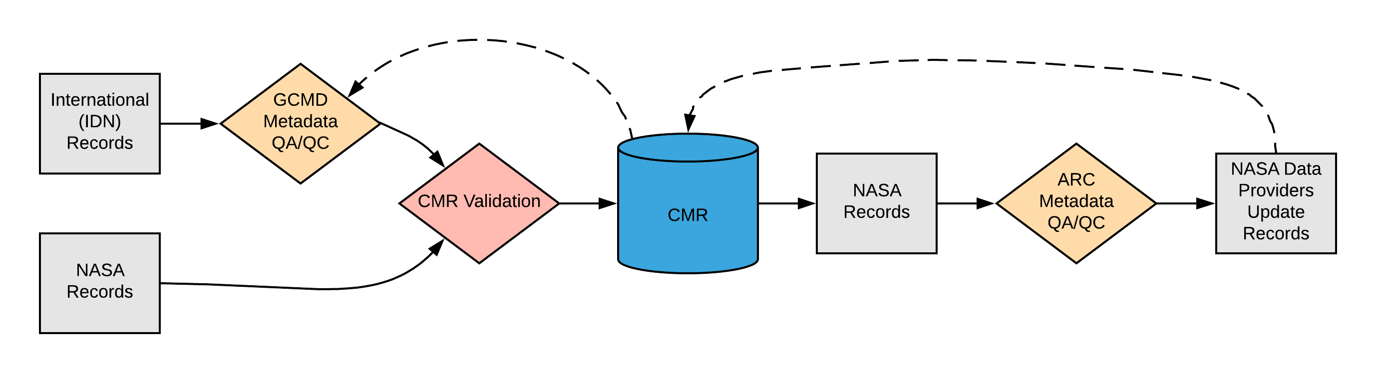
Please see the expandable sections below for flowchart details.
|
|
ARC Automated Checks ARC uses the pyQuARC library for automated metadata checks. Please see the pyQuARC GitHub for more information. |
Dialect Mappings
DIF 10
(1) Bounding Rectangle If Bounding_Rectangle is selected, the cardinality is 1..*
If Point is selected, the cardinality is 1..*
If Line is selected, the cardinality is 1..*
If Polygon is selected, the cardinality is 1..*
Resolution And Coordinate System:
Orbit Parameters: Providing Orbit_Parameters is optional (Cardinality 0..*)
Providing a Vertical_Spatial_Info is optional (Cardinality 0..*)
Example Mapping
|
ECHO 10
(1) Point If Point is selected, the cardinality is 1..*
If BoundingRectangle is selected, the cardinality is 1..*
If Line is selected, the cardinality is 2..* since at least 2 points must be provided to create a Line.
If GPolygon is selected, the cardinality is 1..*
Resolution And Coordinate System:
Vertical Spatial Domain: Providing a Vertical Spatial Domain is optional (Cardinality 0..*)
Providing Orbit Parameters is optional (Cardinality 0..*)
Example Mapping
|
ISO 19115-2 MENDS
Choice of one of the following for Horizontal Spatial Domain/ Geometry: (1) Point If Point is selected, the cardinality is 1..*
(2) Bounding Rectangle If BoundingRectangle is selected, the cardinality is 1..*
(3) Line If Line is selected, the cardinality is 2..* since at least 2 points must be provided to create a Line.
(4) GPolygon If GPolygon is selected, the cardinality is 1..*
Resolution And Coordinate System:
Vertical Spatial Domain: Providing a Vertical Spatial Domain is optional (Cardinality 0..*)
Orbit Parameters: Providing Orbit Parameters is optional (Cardinality 0..*)
Example Mapping
|
ISO 19115-2 SMAP
Choice of one of the following for Horizontal Spatial Domain/ Geometry: (1) Point If Point is selected, the cardinality is 1..*
(2) Bounding Rectangle If BoundingRectangle is selected, the cardinality is 1..*
(3) Line If Line is selected, the cardinality is 2..* since at least 2 points must be provided to create a Line.
(4) GPolygon If GPolygon is selected, the cardinality is 1..*
Resolution And Coordinate System: SMAP metadata records do not contain resolution and coordinate system information. At this time the CMR does not translate SMAP resolution and coordinate system information. Vertical Spatial Domain: Providing a Vertical Spatial Domain is optional (Cardinality 0..*)
Example Mapping
|
UMM Migration
The translation between the operational version of UMM-C 1.13 and the UMM-C 1.14 is almost a one to one mapping. Since the old model doesn't have the descriptions, they can't be translated back or forth. The Horizontal Resolution and Coordinate System information has been moved to be co-located with the horizontal spatial extent information. Translating from the proposed UMM-C back to UMM-C version 1.13 the lower resolution will be used. The value of HorizontalResolutionProcessingLevelEnum is "Not provided". The LongitudeResolution translated to the XDimension element and the LatitudeResolution is translated to the YDimension element.
Future Mappings
|
History
UMM Versioning
| Version | Date | What Changed |
|---|---|---|
| 1.17.0 | 5/1/2022 | Added OrbitParameter sub element Units and Footprints from version 1.16.7 to 1.17.0 |
| 1.15.5 | 12/3/2020 | No changes were made for Spatial Extent during the transition from version 1.15.4 to 1.15.5 |
| 1.15.4 | 9/18/2020 | No changes were made for Spatial Extent during the transition from version 1.15.3 to 1.15.4 |
| 1.15.3 | 7/1/2020 | No changes were made for Spatial Extent during the transition from version 1.15.2 to 1.15.3 |
| 1.15.2 | 5/20/2020 | Added Statute Miles, Nautical Miles, and Not provided as valid values to the HorizontalDataResolutionUnitEnum element. Also Simplified VariesResolution and PointResolution by removing the non needed HorizontalResolutionProcessingLevelEnum sub element from version 1.15.1 to 1.15.2 |
| 1.15.1 | 3/25/2020 | No changes were made for Spatial Extent during the transition from version 1.15.0 to 1.15.1 |
| 1.15.0 | 2/26/2020 |
|
| 1.14.0 | 10/21/2019 |
|
| 1.13.0 | 04/11/2019 | No changes were made for Spatial Extent during the transition from version 1.12.0 to 1.13.0 |
| 1.12.0 | 01/22/2019 | No changes were made for Spatial Extent during the transition from version 1.11.0 to 1.12.0. |
| 1.11.0 | 11/28/2018 | No changes were made for Spatial Extent during the transition from version 1.10.0 to 1.11.0. |
| 1.10.0 | 05/02/2018 | During the transition from version 1.9.0 to 1.10.0, the sub element 'VerticalSpatialDomainType' was enumerated. |
ARC Documentation
| Version | Date | What Changed | Author |
|---|---|---|---|
| 1.0 | 02/19/2018 | Recommendations/priority matrix transferred from internal ARC documentation to wiki space |