Element Description
The Abstract provides a brief description of the resource the metadata represents.
Best Practices
The abstract should summarize the data set and mimic a journal abstract that is useful to the science community but also approachable for a first time user of the data. The following information should be included (when applicable):
- The temporal range of the data set
- The names of platforms, instruments, and/or methods used to collect data
- The spatial coverage of the data (including any gaps in coverage)
- A brief explanation of processing applied to the data
- The format data is provided in and whether proprietary software is required to use it
- Units the data is provided in
- Spatial and temporal resolution of the data
- Similarities and differences of these data to other closely related data sets
- The purpose and/or intended use of the data (especially if the <Purpose> element is not populated)
- If the data were collected as part of a campaign, a brief description of the campaign and how the data set fits into the picture of the campaign
- Any other pertinent information a user might find helpful
In addition, the abstract should utilize a standard mixed case capitalization scheme. All acronyms should be defined. All sentences should be complete sentences and proper grammar should be used.
Examples:
"The GPM Ground Validation Iowa X-band Polarimetric Mobile Doppler Weather Radars IFloodS dataset was gathered during the IFloodS campaign from April to June 2013 throughout central and northeastern Iowa. The Iowa Flood Studies (IFloodS) was a ground measurement campaign that took place throughout Iowa from May 1 to June 15, 2013. The main goal of IFloodS was to evaluate how well the GPM satellite rainfall data can be used for flood forecasting. Four X-band Polarimetric (XPOL) Mobile Doppler Weather Radars were used to collect high-resolution observations of precipitation. The data consists of reflectivity, Doppler velocity, spectrum width, differential reflectivity, differential phase, copolar correlation coefficient, and sound-to-noise ratios. These data are available in netCDF, and browse image files are available in .png format."
"This data set, LBA-ECO LC-39 MODIS Active Fire and Frequency Data for South America: 2000-2007, provides active fire locations and estimates of annual fire frequencies for South America from 2000-2007. Data from the MODerate Resolution Imaging Spectroradiometer (MODIS) sensors aboard the Terra (2000-2007) and Aqua (2003-2007) satellite platforms were analyzed to determine spatial and temporal patterns in satellite fire detections. The analysis considered a high-confidence subset of all MODIS fire detections to reduce the influence of false fire detections over small forest clearings in Amazonia (Schroeder et al., 2008). The number of unique days on which the active fire detections were recorded within a 1 km radius was estimated from the subset of active fire detections and the ArcGIS neighborhood variety algorithm. There are 14 data files with this data set: 7 GeoTIFF (.tif) files of fire frequency at MODIS 250 m resolution, where each grid cell value represents the number of days in that year on which active fires were detected, and 7 shape files of active fire locations for the years 2001-2007."
Element Specification
| Model | Element | Type | Constraints | Required? | Cardinality | Notes |
|---|---|---|---|---|---|---|
| UMM-C | Abstract | String | 40000 maximum characters | Yes | 1 | This element allows markdown-formatted text and line breaks within the text are preserved. Additional information on markdown can be found at http://en.wikipedia.org/wiki/Markdown. |
Metadata Validation and QA/QC
All metadata entering the CMR goes through the below process to ensure metadata quality requirements are met. All records undergo CMR validation before entering the system. The process of QA/QC is slightly different for NASA and non-NASA data providers. Non-NASA providers include interagency and international data providers and are referred to as the International Directory Network (IDN).
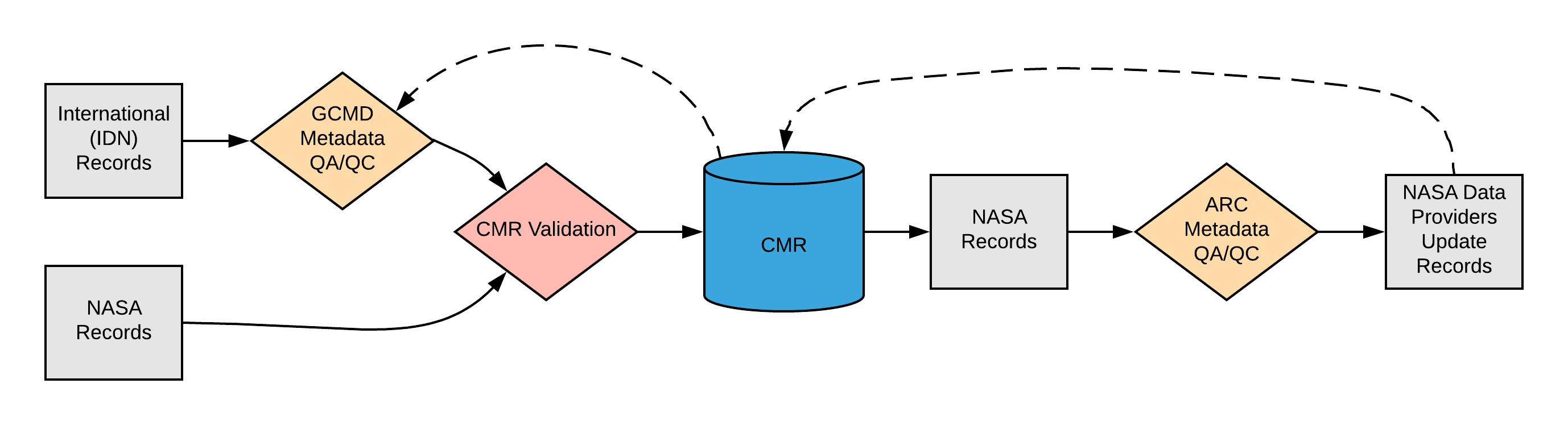
Please see the expandable sections below for flowchart details.
|
<insert description of CMR specific requirements/ warnings here> |
ARC Priority Matrix
ARC Automated Checks
|
Dialect Mappings
DIF 9 DIF 9 (Note: DIF-9 is being phased out and will no longer be supported after 2018) |
DIF 10
Enumeration Mapping N/A Example Mapping
|
ECHO 10
Enumeration Mapping N/A Example Mapping
|
ISO 19115-2 MENDS
Enumeration/Code List Mapping N/A Example Mapping
|
ISO 19115-2 SMAP
Enumeration/Code List Mapping N/A Example Mapping
|
UMM Migration
None
Future Mappings
|
History
UMM Versioning
| Version | Date | What Changed |
|---|---|---|
| 1.0.0 | Initial Release |
ARC Documentation
| Version | Date | What Changed | Author |
|---|---|---|---|
| 1.0 | 4/10/18 | Recommendations/priority matrix transferred from internal ARC documentation to wiki space | Jeanne' le Roux |