Page History
The ISO Family of Geospatial Metadata Standards
There are multiple standards within the ISO Technical Committee 211 for geospatial standards. In many cases, multiple standards are required to adequately describe the unique characteristics of a dataset. In the case of ISO 19115 compliance, the most immediately relevant ISO standards are:
- ISO 19115 Geographic information -- Metadata (updated by ISO 19115-1)
- ISO 19115-1 Geographic information -- Metadata -- Part 1: Fundamentals
- ISO 19115-2 Geographic information -- Metadata -- Part 2: Extensions for imagery and gridded data
- ISO 19115-3 Geographic information -- Metadata -- Part 3: XML schema implementation of metadata fundamentals
- ISO 19139 Geographic information -- Metadata -- XML schema implementation (see also 19115-3)
- ISO 19157 Geographic information -- Data quality
Additional standards focus on topics such as land cover, GML, geodesy, geppositioning.
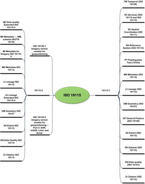
It is important to note that, within one standard, multiple standards are often referenced (Figure 1).

A scenario for ISO conformance for a land cover product derived from radar data might follow the following steps:
- Review of the ISO 19115 standard and applicable its packages (Figure 2).
- Review of the ISO 19115:2003 and 19115-2 standards for packages relating to radar data (Figure 3).
- Review of the ISO of the ISO 19144-1 and 19144-2 standards for packages relating to land cover (Figure 4).
| Section | ||||||
|---|---|---|---|---|---|---|
Figures 2-4: Relationship Between ISO Standards
|


In the end, the ISO family of standards is broad enough to allow for metadata on everything from high-level mission strategies to the details of provenance and instrument structure. The child pages contains links to normative references/standards pertinent to the generation and expansion of NASA ISO-19115 compliant metadata.
Development of Best Practices for ISO 19115
| Info | ||
|---|---|---|
| ||
| Additional information on the NASA Conventions and Extensions can be viewed here: NASA ISO Conventions and Extensions |
Thusfar, the NASA Best Practices for ISO 19115 have drawn upon conventions and extensions to ISO 19115:2003 and ISO 19115-2. They incorporate other forward-looking elements such as ISO 19115-1, lineage and have room for stakeholder outreach and feedback. Figure 2 illustrates the paradigm driving the Best Practices development process. (Figure 2).
| Hide comments |
|---|
Overview
Content Tools