Page History
The NASA Worldview Snapshots tool enables users to easily create satellite imagery subsets for anywhere in the world. The tool provides access to current and historical imagery captured by Terra and Aqua MODIS and S-NPP and NOAA-20 VIIRS. By simply selecting the desired image product, acquisition date, spatial resolution, output file type as well as entering the latitude/longitude bounding box, users can quickly generate an imagery subset to use for visualization in a GIS or as a graphic in a presentation or document.
For the convenience of users who need to create satellite imagery subsets of geopolitical units, Snapshots has recently been enhanced to include predefined latitude/longitude bounding boxes for countries. After setting the basic parameters for an imagery subset, users can simply select their desired country of interest from the Countries dropdown list in Country/Region Presets box below the map. The red box that subsequently appears on the map indicates the bounding box of the subset to be generated. Users can also increase the default size of the subset boundary extent by 5% to 20% by selecting the desired 5% interval under the Padding dropdown list or manually edit the predefined coordinates as desired in the Bounding Box section of the interface.
Users can also generate imagery subsets for a US state or Canadian province or territory. After selecting either of these two countries, a user can select the State / Province / Region dropdown list to update the subset bounding box extent to the targeted state, province or territory.

A September 9, 2022 Aqua MODIS true color composite image for Oregon generated from NASA Worldview Snapshots. The subset bounding box is defined by the map extent of the state, predefined in Snapshots, and extended by an additional 5% in both dimensions.
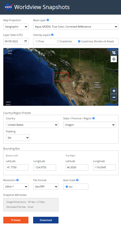
A screenshot of the Worldview Snapshots definition for an imagery subset of the state or Oregon. The updated interface enables users to select a country (as well as a US state and Canadian province/territory) and use its associated map extent as the bounding box coordinates for the subset boundary. If desired, users can increase the size of the predefined bounding box in 5% intervals or edit manually edit the coordinates.
Overview
Content Tools