Versions Compared

Key

  • This line was added.
  • This line was removed.
  • Formatting was changed.

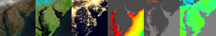
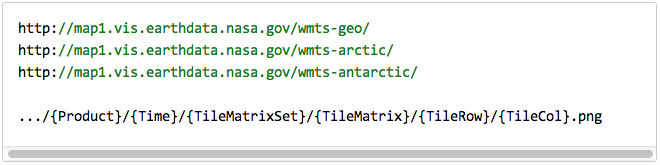
The Global Imagery Browse Services (GIBS) system is a core EOSDIS component which provides a scalable, responsive, highly available, and community standards based set of imagery services.  These services are designed with the goal of advancing  user interactions with EOSDIS’ inter-disciplinary data through enhanced visual representation and discovery.  For a full overview, visit the GIBS landing page.  For open source code to the GIBS OnEarth server, MRF tiled imagery storage format, and mapping examples, see the GIBS GitHub page.  For detailed information about available imagery products and accessing GIBS, see below.


Anchor
user-info
user-info
Information for Users:

UI Button
colorgreen
sizesmall
displayblock
icontext
titleImagery Products
urlhttps://wiki.earthdata.nasa.gov/display/GIBS/GIBS+Available+Imagery+Products

UI Button
colorgreen
sizesmall
displayblock
icontext
titleGIBS API for Developers
urlhttps://wiki.earthdata.nasa.gov/display/GIBS/GIBS+API+for+Developers


UI Button
colorgreen
sizesmall
displayblock
icontext
titleMap Library Usage
urlhttps://wiki.earthdata.nasa.gov/display/GIBS/Map+Library+Usage

UI Button
colorgreen
sizesmall
displayblock
icontext
titleGIS Tool Usage
urlhttps://wiki.earthdata.nasa.gov/display/GIBS/Geographic+Information+System+%28GIS%29+Usage

Anchor
collaborator-info
collaborator-info
Information for Collaborators:

Anchor
collaborator-info
collaborator-info
Information for Everyone

Hide comments