Versions Compared

Key

  • This line was added.
  • This line was removed.
  • Formatting was changed.

The Global Imagery Browse Services (GIBS) system is a core EOSDIS component which provides a scalable, responsive, highly available, and community standards based set of imagery services.  These services are designed with the goal of advancing  user interactions with EOSDIS’ inter-disciplinary data through enhanced visual representation and discovery.  For a full overview, visit the GIBS landing page.  For open source code to the GIBS OnEarth server, MRF tiled imagery storage format, and mapping examples, see the GIBS GitHub page.  For detailed information about available imagery products and accessing GIBS, see below.vision is to provide visual access to NASA’s Earth observations through standardized web services. These services are designed to facilitate visual discovery of scientific phenomena, support timely decision making for natural hazards, educate the next generation of scientists, and make imagery of the planet more accessible to the media and public. Browse all of this imagery through our Worldview interface.


Image Added


Anchor
user-info
user-info

Information for Users:

UI Button
colorgreen
sizesmall
displayblock
icontext
titleImagery Products
urlhttps://wiki.earthdata.nasa.gov/display/GIBS/GIBS+Available+Imagery+Products

UI Button
colorgreen
sizesmall
displayblock
icontext
titleGIBS API for Developers
urlhttps://wiki.earthdata.nasa.gov/display/GIBS/GIBS+API+for+Developers

Anchor
collaborator-info
collaborator-info
Stay Informed

Open Source Code: GIBS on GitHub

  • OnEarth: High-performance web services for tiled raster imagery and vector tiles
  • MRF Tiled Imagery Storage Format: GDAL-compatible file format driver designed for fast access to imagery
  • Mapping Examples: Examples of using GIBS with various web mapping libraries
  • Worldview: Interactive interface for browsing daily, global, full-resolution satellite imagery

Blog Posts
max5
sortcreation
reversetrue
contenttitles


Image Removed

UI Button
colorgreen
sizesmall
displayblock
icontext
titleMap Library Usage
urlhttps://wiki.earthdata.nasa.gov/display/GIBS/Map+Library+Usage

UI Button
colorgreen
sizesmall
displayblock
icontext
titleGIS Tool Usage
urlhttps://wiki.earthdata.nasa.gov/display/GIBS/Geographic+Information+System+%28GIS%29+Usage

Anchorcollaborator-infocollaborator-infoInformation for Collaborators:

GIBS Technical Working Group

Anchorcollaborator-infocollaborator-infoInformation for Everyone
Panel
borderColorMaroon
titleColorBlack
titleBGColorWhite
titleInformation about working with this wiki:
Expand

Purpose of the Wiki

This wiki is intended strictly for the use of sharing information about NASA Earth Observing Systems Data and Information System (EOSDIS) topics. For more information please click here .

We welcome your participation and comments within Earthdata Wiki.

Rules of Conduct

Earthdata Wiki is governed by the general rules of respectful civil discussion. EOSDIS may monitor any user-generated content as it chooses and reserves the right to remove content for any reason whatsoever, without consent. The following rules of conduct are to be followed when using the Earthdata Wiki. Breach of these rules will result in users loses privileges or being banned permanently.

Participation requires a valid Earthdata Login. Only approved NASA users and affiliates will be allowed to upload data. If a wiki space becomes dormant for a period of more than 2 years, ESDIS reserves the right to delete/remove it.

In order to maintain an environment where everyone is welcome and discussion flows freely, certain types of conduct are prohibited on Earthdata Wiki. Specifically restricted conduct includes trolling, flaming, ranting, personal attacks, harassment, threats, doxing, racism, discrimination, hate speech, sexism, spamming, off-topic posting, pyramid quoting, rumor mongering, impersonation, advertising (including HTML links and pictures), and linking to applications or utilities of uncertain intent.

In addition, the Earthdata Wiki is not for discussion of real-life current affairs, news, politics, or religion. Discussion should revolve around EOSDIS topics. Specific content prohibited on Earthdata Wiki includes pornography, profanity, and real money trading (RMT).


NASA makes no representations or warranties regarding the information posted.
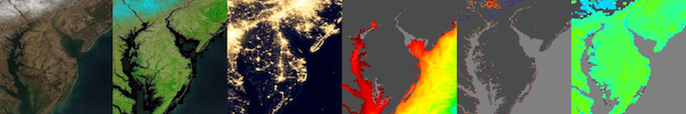
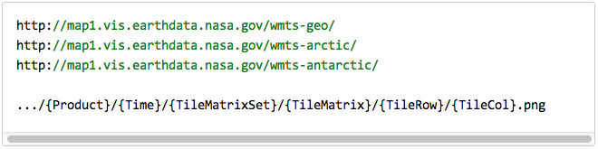
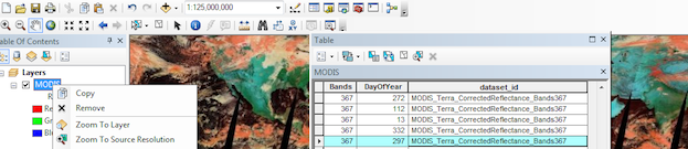
Hide comments

NASA Official: Stephen Berrick